geocat.ch
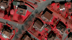
SWISSIMAGE RS
SWISSIMAGE RS se compose de bandes d’images orthorectifiées et divisées en plusieurs segments contenant 4 bandes spectrales : le proche infrarouge, le rouge, le vert et le bleu. Grâce à une production simplifiée, ces orthophotos sont produites et livrées dans un intervalle court, entre 4 et 6 mois après l’acquisition des images. La structure en orthophotos individuelles permet également de connaître la date et l’heure d’acquisition pour chaque bande d’image.
Simple
- Date (Creation)
- 2017-01-01
- Identifier
- 433
- Purpose
-
Base de travail pour les études environnementales
- Status
- On going
Custodian
- Spatial representation type
- Grid
Spatial resolution
- Spatial resolution
- 0.25 m
- Topic category
-
- A Imagery base maps earth cover
Extent
Extent
- Description
-
Canton of Valais (VS)
))

- Maintenance and update frequency
- userDefined
- Maintenance note
-
La mise à jour s’effectue par secteur suivant un cycle de 3 ans.
Resource format
- Title
-
ESRI Enterprise Geodatabase
- Date
- GEMET
-
-
satellite image
-
- geocat.ch
-
-
orthophoto
-
official geodata
-
Resource constraints
- Use limitation
-
contraintes swisstopo
Resource constraints
- Access constraints
- Other restrictions
- Other constraints
-
Les conditions générales d'utilisation des géodonnées du Canton du Valais font foi ( https://www.vs.ch/fr/web/guest/information-legale).
- Language
- Français
- Character encoding
- UTF8
- Language
- Deutsch
- Character encoding
- UTF8
- Subtopic Category
- A3 Aerial and Satellite Imagery
- Basic Geodata
- true
- Basic Geodata ID
-
35
- Basic Geodata Legal Level
- Federal
- Basic Geodata Type
- Reference Geodata
- Distribution format
-
-
GeoTIFF (GEOTIFF)
-
Cloud Optimized GeoTIFF (TIFF / TIF)
-
Distributor
- Statement
-
Bandes d'images produites à partir des prises aériennes
- Hierarchy level
- Dataset
- Description
-
numérique
- Reference system identifier
- EPSG:2056/CH1903+_MN95
Metadata
- Metadata identifier
- b29035b6-7797-47f3-9442-38ac10f16a62
- Language
- Français
- Character encoding
- UTF8
- Language
- Deutsch
- Character encoding
- UTF8
- Language
- Italiano
- Character encoding
- UTF8
- Language
- English
- Character encoding
- UTF8
- Language
- Rumantsch
- Character encoding
- UTF8
Distributor
Type of resource
- Resource scope
- Dataset
- Metadata linkage
-
https://www.geocat.ch/geonetwork/srv/api/records/b29035b6-7797-47f3-9442-38ac10f16a62
- Date info (Creation)
- 2017-11-06T13:54:44Z
- Date info (Revision)
- 2026-05-18T12:19:19.816311Z
Metadata standard
- Title
-
eCH-0271