 geocat.ch
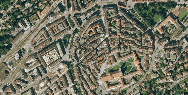
Orthophoto des Kantons St.Gallen 2009
Das Orthophoto 2009 ist eine Zusammensetzung digitaler Farbluftbilder. Die Auflösung beträgt 25cm. Die Aufnahmen stammen aus den Sommer/Herbst 2009, somit wird die belaubte Vegetation dargestellt.
Simple
- Date (Creation)
- 2015-01-26
- Date (Revision)
- 2026-06-21
- Other citation details
-
Luft-, Satellitenbilder
- Purpose
-
-
- Status
- Completed
partner
Amt für Raumentwicklung und Geoinformation - geodaten@sg.ch
Lämmlisbrunnenstrasse 54
St. Gallen
9001
CH
Homepage
- Hours of service
-
Mo. - Fr. von 8:00 - 17:00 Uhr
- Spatial representation type
- Grid
Spatial resolution
Equivalent scale
- Denominator
- 1000
Extent
Extent
- Description
-
Kanton St.Gallen
N
S
E
W
))
- Maintenance and update frequency
- Irregular
- geocat.ch
-
-
Orthofoto
-
- GEMET
-
-
Luftbild
-
Resource constraints
- Access constraints
- Other restrictions
- Other constraints
-
A = öffentlich
Resource constraints
- Classification
- Unclassified
- Language
- Deutsch
- Subtopic Category
- A3 Aerial and Satellite Imagery
- Distribution format
-
-
GeoTIFF
-
Distributor
Amt für Raumentwicklung und Geoinformation - geodaten@sg.ch
Lämmlisbrunnenstrasse 54
St. Gallen
9001
CH
Homepage
- Hours of service
-
Mo. - Fr. von 8:00 - 17:00 Uhr
Digital transfer options
- Statement
-
Flugdatum:
31.08.2009 10:20-15:55, wolkenlos, leichter Dunst
01.09.2009 09:53-13:40, wolkenlos, leichter Dunst
07.09.2009 11:56-15:56, teilweise Cirrus, dunstig
Längsüberdeckung 80% (Minimal 70%)
Querüberdeckung 30% (Minimal 25%)
Anzahl Flugstreifen: 39
Anzahl Flugaufnahmen: 1940
- Hierarchy level
- Dataset
- Reference system identifier
- CH1903+_LV95 / EPSG 2056
Metadata
- Metadata identifier
- b0ee5aa4-e495-4205-a5fd-74be571f4529-8371
- Language
- Deutsch
- Character encoding
- UTF8
Resource provider
Amt für Raumentwicklung und Geoinformation - geodaten@sg.ch
Lämmlisbrunnenstrasse 54
St. Gallen
9001
CH
Homepage
- Hours of service
-
Mo. - Fr. von 8:00 - 17:00 Uhr
Type of resource
- Resource scope
- Dataset
- Date info (Revision)
- 2026-06-21T01:15:41+02:00
Metadata standard
- Title
-
GM03 Core
)))
