geocat.ch
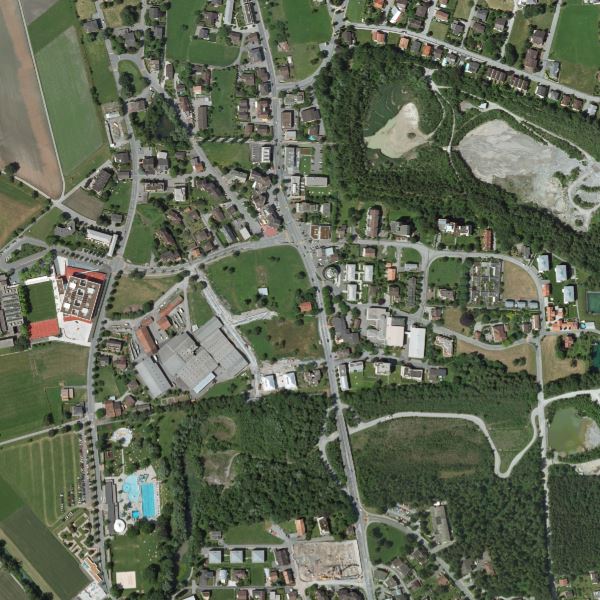
Orthophoto Liechtenstein 2009
Orthophoto with a resolution of 12.5 cm ground pixels. The orthophoto was flown from 17 June to 29 July 2009 with an Ultracam XP digital area scan camera. The flight altitude above ground was approx. 2200m.
The orthophoto is available in true colour (RGB) as well as in infrared (CIR).
Simple
- Date (Creation)
- 2009-08-31
- Identifier
- https://metadata.geo.llv.li/b0b45bd3-e556-4641-97e3-641c94ec6567
- Purpose
-
Basic data of the GDI-Liechtenstein
- Status
- Completed
Publisher
- Hours of service
-
8:00-11:30 und 13:30-17:00
- Spatial representation type
- Grid
Spatial resolution
- Spatial resolution
- 0.125 m
- Topic category
-
- A Imagery base maps earth cover
Extent
Extent
- Description
-
Liechtenstein
))

- Maintenance and update frequency
- Not planned
Resource format
- Title
-
GeoTIFF (GEOTIFF)
- Date
- geocat.ch
-
-
INSPIRE
-
orthophoto
-
OpenData
-
digital color orthophoto mosaic
-
- GEMET - INSPIRE themes, version 1.0
-
-
Orthoimagery
-
- Räumlicher Anwendungsbereich
-
-
National
-
Resource constraints
- Use limitation
-
No Conditions apply
- Access constraints
- Other restrictions
- Use constraints
- Other restrictions
- Other constraints
- No limitations to public access
Resource constraints
- Access constraints
- Other restrictions
- Use constraints
- Other restrictions
- Other constraints
- No conditions to access and use
- Other constraints
- Opendata BY: Open use. Must provide the source.
- Language
- Deutsch
- Character encoding
- UTF8
- Environment description
-
Ultracam XP - Digitale Flächenkamera
- Subtopic Category
- A3 Aerial and Satellite Imagery
- Attribute description
- RGB-Farbwert
- Distribution format
-
-
GeoTIFF (GEOTIFF)
-
Point of contact
- Hours of service
-
8:00-11:30 und 13:30-17:00
Digital transfer options
Digital transfer options
- Units of distribution
-
1 Kachel
- OnLine resource
-
li.abi.orthophoto2009
OGC WMS Service of the Liechtenstein State Administration
Digital transfer options
- Units of distribution
-
1 Kachel
- OnLine resource
-
Download als GeoTiff über das Geodatenportals
Download as GeoTiff via the geodata portal
- Hierarchy level
- Dataset
Report
Result
- Title
-
VERORDNUNG (EG) Nr. 1089/2010 DER KOMMISSION vom 23. November 2010 zur Durchführung der Richtlinie 2007/2/EG des Europäischen Parlaments und des Rates hinsichtlich der Interoperabilität von Geodatensätzen und -diensten
- Date (Publication)
- 2010-12-08
- Explanation
-
Gemäss INSPIRE Bestandteil des Themas Orthofotografie
- Pass
- false
- Statement
-
Luftbildbefliegung aus einer Flughöhe von ca. 2200m über Grund
- Hierarchy level
- Dataset
- Description
-
digitale Luftbilder
- Number of dimensions
- 2
- Cell geometry
- Area
- Transformation parameter availability
- 1
- Reference system identifier
- http://www.opengis.net/def/crs/EPSG/0/2056
- Reference system identifier
- http://www.opengis.net/def/crs/EPSG/0/4936
- Maintenance and update frequency
- As needed
Metadata
- Metadata identifier
- b0b45bd3-e556-4641-97e3-641c94ec6567
- Language
- Deutsch
- Character encoding
- UTF8
- Language
- Français
- Character encoding
- UTF8
- Language
- Italiano
- Character encoding
- UTF8
- Language
- English
- Character encoding
- UTF8
Point of contact
- Hours of service
-
8:00-11:30 und 13:30-17:00
Type of resource
- Resource scope
- Dataset
- Metadata linkage
-
https://www.geocat.ch/geonetwork/srv/api/records/b0b45bd3-e556-4641-97e3-641c94ec6567
- Date info (Creation)
- 2010-03-23T13:28:16Z
- Date info (Revision)
- 2026-04-13T09:32:48.34546Z
Metadata standard
- Title
-
eCH-0271