 geocat.ch
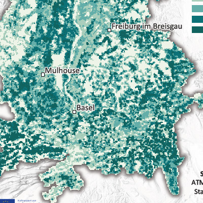
Ammonia emissions per 500 m grid cell in the Upper Rhine region (2021)
Produced as part of the Interreg Upper Rhine Atmo-Rhena PLUS project, this map shows ammonia (NH3) emissions in the Upper Rhine region in 2021.
Limiting air pollutant emissions is the most important lever for reducing pollutant concentrations in the atmosphere.
Ammonia is a gaseous compound in the atmosphere. At very high concentrations, this gas irritates the respiratory tract and eyes. At concentrations typically found in ambient air, its direct health effects are low, unlike its environmental effects (ammonia plays a major role in the acidification and eutrophication of natural environments). In addition, ammonia reacts with other substances in the atmosphere to form secondary fine particles.
Ammonia is mainly emitted by agriculture, primarily through fertiliser spreading and animal waste from livestock farming. In urban areas, the residential sector, waste management, certain industries and road transport are also responsible for ammonia emissions.
This map shows the distribution of annual ammonia emissions in the Upper Rhine Valley. These emissions are often linked to agricultural practices, particularly intensive livestock farming and the spreading of organic fertilisers. The foothills often have at least intermediate levels, reflecting moderate agricultural activity. Large urban areas appear to be relatively low in emissions.
The static map in PDF format is available at a scale of 500m. The data is accessible as open data only at the scale of EPCI, Kreis and Cantons.
Simple
- Date (Creation)
- 2025-08-07
- Date (Publication)
- 2025-11-07
- Identifier
- AtmoRhenaPlus_nh3_maille_500m
- Status
- Completed
Point of contact
- mri:deliveryPoint
-
100, avenue d'Alsace
- mri:city
-
COLMAR
- mri:postalCode
-
68000
- Country
-
FRANCE
- mri:electronicMailAddress
Point of contact
- mri:deliveryPoint
-
5, rue de Madrid
- mri:city
-
Schiltigheim
- mri:postalCode
-
67300
- Country
-
France
- mri:electronicMailAddress
Point of contact
- mri:deliveryPoint
-
Griesbachstraße 1
- mri:city
-
Kalrsruhe
- mri:postalCode
-
76185
- mri:electronicMailAddress
Point of contact
- mri:deliveryPoint
-
Rheinstrasse 29
- mri:city
-
Liestal
- mri:postalCode
-
4410
- mri:electronicMailAddress
Point of contact
- mri:deliveryPoint
-
Kaiser-Friedrich-Straße 7
- mri:city
-
Mainz/Rhein
- mri:postalCode
-
55116
- mri:electronicMailAddress
Point of contact
- mri:deliveryPoint
-
Bel'Oiseau 12, Case postale 69
- mri:city
-
Saint-Ursanne
- mri:postalCode
-
2882
- mri:electronicMailAddress
Point of contact
- mri:deliveryPoint
-
Entfelderstrasse 22
- mri:city
-
Aarau
- mri:postalCode
-
5001
- mri:electronicMailAddress
- Spatial representation type
- Vector
Spatial resolution
Equivalent scale
- Denominator
- 50000
- Topic category
-
- L Environment
- N Health
Extent
Extent
Temporal extent
- Time period
- 2020-01-01 2021-12-31
Extent
Extent
))
- Maintenance and update frequency
- Not planned
- Theme
-
-
Upper Rhine
-
Crossborder
-
Resource constraints
- Use limitation
-
CC-BY Licence ©OpenStreetMap contributors ©GeoRhena
Resource constraints
- Access constraints
- Other restrictions
- Use constraints
- Other restrictions
- Other constraints
-
No other limitation
- Language
- Français
- Character encoding
- UTF8
- Language
- Deutsch
- Character encoding
- UTF8
- Language
- English
- Character encoding
- UTF8
Digital transfer options
- OnLine resource
-
0
Ammonia Emmissions
Digital transfer options
- OnLine resource
-
Ammonia Emmissions
Digital transfer options
- OnLine resource
-
Upper Rhine Air Quality Portal
Digital transfer options
- OnLine resource
-
Ammonia emissions per 500m mesh
Digital transfer options
- OnLine resource
-
Brochure on NH3 measurements in the Upper Rhine
Digital transfer options
- OnLine resource
-
Upper Rhine Air-Climate-Energy Dashboard
- Statement
-
Collection of estimated emissions for the Grand Est region (ATMO Grand Est), Baden-Württemberg (Landesanstalt für Umwelt Baden-Württemberg – LUBW), the cantons of Basel-Stadt and Basel-Landschaft (Lufthygienamt Beider Basel – LHA), Rhineland-Palatinate (Landesamt für Umwelt Rheinland-Pfalz – LfU), the Canton of Jura (Office de l'environnement - ENV Jura) and the Canton of Aargau (Departement Bau, Verkehr und Umwelt – BVU Aargau). Data for the cantons of Jura, Aargau and Solothurn were recorded based on cantonal or municipal data.
- Hierarchy level
- staticMap
Metadata
- Metadata identifier
- b083f353-9c12-4001-a409-3d78e854a604
- Language
- Français
- Character encoding
- UTF8
- Language
- English
- Character encoding
- UTF8
- Language
- Deutsch
- Character encoding
- UTF8
Contact
- mdb:deliveryPoint
-
100, avenue d'Alsace
- mdb:city
-
COLMAR
- mdb:postalCode
-
68000
- mdb:country
-
FR
Type of resource
- Resource scope
- staticMap
- Date info (Revision)
- 2025-11-10T09:31:13.912185Z
Metadata standard
- Title
-
ISO 19115-3:2018
- Edition
-
1.0
)))