geocat.ch
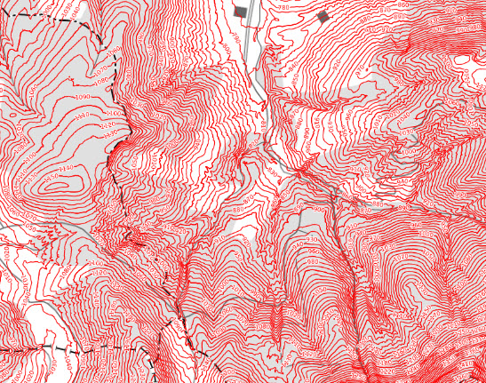
Höhenkurven (ZG)
Der Datensatz enthält Höhenkurven zur Darstellung des Geländeverlaufs im Kanton Zug. Die Höhenlinien wurden aus dem digitalen Höhenmodell swissALTI3D von swisstopo berechnet, welches auf LIDAR-Befliegungen der Jahre 2018 und 2019 basiert. Die Daten ermöglichen die Analyse von Topografie, Hangneigungen und Geländestrukturen und werden unter anderem für Raumplanung, Infrastrukturprojekte, Umweltanalysen sowie kartografische Anwendungen verwendet. Die Geometrien liegen im Referenzsystem CH1903+ / LV95 (EPSG:2056) vor.
Simple
- Date (Publication)
- 2020-07-11
- Status
- Completed
Owner
- Spatial representation type
- Vector
- Topic category
-
- E Planning cadastre
Extent
Extent
- Description
-
Canton of Zug (ZG)
))

- Maintenance and update frequency
- Unknown
- geocat.ch
-
-
contour line
-
DEM (digital elevation model)
-
spot elevation
-
- GEMET
-
-
altitude
-
Resource constraints
- Access constraints
- Restricted
Associated resource
- Association Type
- Reference from one resource to another
- Metadata Reference
- Language
- Deutsch
- Subtopic Category
- E2 Cadastre, Land Registry
- Distribution format
-
-
OGC Web Feature Service (WFS)
-
Digital transfer options
- OnLine resource
-
Höhenkurven und Isobathen
- OnLine resource
-
GeoShop Kanton Zug
Digital transfer options
- OnLine resource
-
Höhenkurven
Identifier
- Code
- EPSG:2056
- Description
-
CH1903+ / LV95 (EPSG:2056)
Metadata
- Metadata identifier
- ad1cbe16-c559-4e50-82af-345287817d1d
- Language
- Deutsch
- Character encoding
- UTF8
- Language
- Français
- Character encoding
- UTF8
- Language
- Italiano
- Character encoding
- UTF8
- Language
- English
- Character encoding
- UTF8
Distributor
Type of resource
- Resource scope
- Dataset
- Metadata linkage
-
https://www.geocat.ch/geonetwork/srv/api/records/ad1cbe16-c559-4e50-82af-345287817d1d
- Date info (Creation)
- 2015-04-21T10:38:46Z
- Date info (Revision)
- 2026-06-12T13:24:54.342924Z
Metadata standard
- Title
-
eCH-0271