geocat.ch
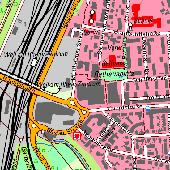
Kataster Landkreis Lörrach
Standardisierte Rasterdarstellung der deutschen Vermessungsdaten (DLM- und ALK-Gebäudedaten).
Simple
- Date (Creation)
- 2011-09-06
- Status
- Completed
Owner
- Spatial representation type
- Grid
Spatial resolution
- Spatial resolution
- 0.5 m
Spatial resolution
Equivalent scale
- Denominator
- 10000
- Topic category
-
- A Imagery base maps earth cover
Extent
Extent
- Description
-
Deutschland im Gebiet des Stadtplans Basel-Stadt
- Geographic identifier
- Landkreis Lörrach
))

- Maintenance and update frequency
- Annually
- geocat.ch
-
-
city map
-
- GEMET
-
-
land and property register
-
- GEMET
-
-
land register
-
Resource constraints
- Other constraints
-
Die Geodaten sind beschränkt öffentlich zugänglich. (Zugangsberechtigungsstufe [B1] = intern)
- Other constraints
-
Es gelten die Nutzungsbedingungen für Geodaten des Kantons Basel-Stadt. ( http://www.geo.bs.ch/agb)
Associated resource
- Title
-
Kataster Landkreis Lörrach
- Association Type
- Reference to a master resource of which this one is a part
- Language
- Deutsch
- Character encoding
- UTF8
- Subtopic Category
- A1 Base Maps, Landscape Models
- Distribution format
-
-
INTERLIS 1 (ITF)
-
Digital transfer options
- OnLine resource
-
MapBS
Öffentliches Auskunftssystem des Kantons Basel-Stadt
Digital transfer options
- OnLine resource
-
WMS BS
Die derzeit im WMS BS verfügbaren Datenebenen entsprechen, bis auf wenige Ausnahmen, den Geodaten, welche auch in MapBS dargestellt sind. Der WMS BS ist kostenlos nutzbar und bietet Zugriff auf öffentliche sowie beschränkt öffentliche Geodaten, wobei gegebenenfalls Benutzername und Passwort benötigt werden (Zugangsdaten von MapBS).
Digital transfer options
- OnLine resource
-
WFS BS
Die derzeit im WFS BS verfügbaren Datenebenen entsprechen, bis auf wenige Ausnahmen, den Geodaten, welche auch in MapBS dargestellt sind. Der WFS BS ist kostenlos nutzbar und bietet Zugriff auf öffentliche sowie beschränkt öffentliche Geodaten, wobei gegebenenfalls Benutzername und Passwort benötigt werden (Zugangsdaten von MapBS).
- Reference system identifier
- CH1903+ / LV95/EPSG: 2056
Metadata
- Metadata identifier
- acabc4b1-b425-41f7-8169-9647eda02bf4
- Language
- Deutsch
- Character encoding
- UTF8
- Language
- Français
- Character encoding
- UTF8
- Language
- Italiano
- Character encoding
- UTF8
- Language
- English
- Character encoding
- UTF8
Custodian
Type of resource
- Resource scope
- Dataset
- Metadata linkage
-
https://www.geocat.ch/geonetwork/srv/api/records/acabc4b1-b425-41f7-8169-9647eda02bf4
- Date info (Creation)
- 2011-09-30T11:45:18Z
- Date info (Revision)
- 2026-04-13T09:41:29.039754Z
Metadata standard
- Title
-
eCH-0271