geocat.ch
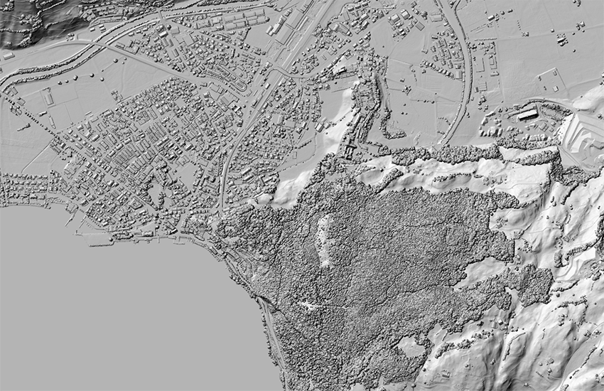
swissSURFACE3D Raster monodirectional hillshade
The hillshade is derived from the digital elevation model swissSURFACE3D Raster. It illustrates the surface relief of Switzerland and the Principality of Liechtenstein. A hillshade is derived from the elevation model by calculating the exposure of the surface to sunlight at a certain or several angles. The monodirectional swissSURFACE3D Raster hillshade is generated using a northwestern sun position as light source.
Simple
- Alternate title
-
swissSURFACE3D Raster monodirectional hillshade
- Date (Publication)
- 2020-10-28
- Identifier
- ch.swisstopo.swisssurface3d-reliefschattierung_monodirektional
Point of contact
- Spatial representation type
- Grid
Spatial resolution
- Spatial resolution
- 0.5 m
- Topic category
-
- C Elevation
Extent
Extent
- Description
-
Switzerland
))

Extent
Extent
- Description
-
Liechtenstein
))

- Maintenance and update frequency
- Annually
- Maintenance note
-
A hillshade calculation is carried through on the updated parent data set swissSURFACE3D Raster.
- GEMET
-
-
laser
-
relief (land)
-
geographic information system
-
digital land model
-
- geocat.ch
-
-
opendata.swiss
-
3D simulation
-
DEM (digital elevation model)
-
LIDAR (Light Detection And Ranging)
-
GIS (Geographic Information System)
-
3D visualisation
-
laserscanning
-
- GEMET - INSPIRE themes, version 1.0
-
-
Elevation
-
- geocat.ch
-
-
FSDI Federal Spatial Data Infrastructure
-
Resource constraints
- Other constraints
-
NonCommercialAllowed-CommercialAllowed-ReferenceRequired
Associated resource
- Association Type
- Reference to a master resource of which this one is a part
- Metadata Reference
Associated resource
- Title
-
Höhendaten (Landesvermessung)
- Association Type
- Reference to a master resource of which this one is a part
- Language
- Deutsch
- Character encoding
- UTF8
- Language
- English
- Character encoding
- UTF8
- Basic Geodata
- true
- Basic Geodata ID
-
41.6
- Basic Geodata Legal Level
- Federal
- Distribution format
-
-
Tagged Image File Format (TIFF)
-
Digital transfer options
- OnLine resource
-
Vorschau map.geo.admin.ch
Preview map.geo.admin.ch
Digital transfer options
- OnLine resource
-
ch.swisstopo.swisssurface3d-reliefschattierung_monodirektional
WMS-FSDI service, layer "swissSURFACE3D Raster monodirectional hillshade"
Digital transfer options
- OnLine resource
-
ch.swisstopo.swisssurface3d-reliefschattierung_monodirektional
WMTS-FSDI service, layer "swissSURFACE3D Raster monodirectional hillshade"
- Number of dimensions
- 2
- Cell geometry
- Point
- Transformation parameter availability
- 1
- Reference system identifier
- EPSG:21781
- Reference system identifier
- EPSG:21781
- Reference system identifier
- EPSG:5728
Metadata
- Metadata identifier
- ac330de2-572c-4602-acbc-ca4ba80e9d69
- Language
- Deutsch
- Character encoding
- UTF8
- Language
- Français
- Character encoding
- UTF8
- Language
- Italiano
- Character encoding
- UTF8
- Language
- English
- Character encoding
- UTF8
- Language
- Rumantsch
- Character encoding
- UTF8
Point of contact
Type of resource
- Resource scope
- Dataset
- Metadata linkage
-
https://www.geocat.ch/geonetwork/srv/api/records/ac330de2-572c-4602-acbc-ca4ba80e9d69
- Date info (Creation)
- 2020-08-28T08:13:52Z
- Date info (Revision)
- 2026-04-13T09:22:55.624031Z
Metadata standard
- Title
-
eCH-0271