 geocat.ch
Documents d’aménagement du territoire nationaux/régionaux/cantonaux de la Grande Région et du Rhin Supérieur - 2024
Raumplanungsdokumente auf Landes-/Kantonsebene der Großregion und des Oberrheins - 2024
National/regional/cantonal spatial planning documents for the Greater Region and the Upper Rhine - 2024
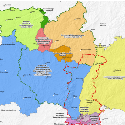
Carte représentant les périmètres des différents documents d’aménagement du territoire de la Grande Région et du Rhin Supérieur, à l'échelle nationale (Luxembourg), régionale (Belgique, France et Allemagne) et cantonale (Suisse).
Karte, auf der die Perimeter der verschiedenen Raumplanungsdokumente für die Gebiete der Großregion und des Oberrheins auf nationaler (Luxemburg), regionaler (Belgien, Frankreich und Deutschland) und kantonaler (Schweiz) Ebene dargestellt sind.
Map showing the boundaries of the various spatial planning documents in the Greater Region and the Upper Rhine, at national (Luxembourg), regional (Belgium, France and Germany) and cantonal (Switzerland) level.
Simple
-
Datum (Erstellung)Date (Creation)Date (Création)
- 2024-06-01
-
Datum (Publikation)Date (Publication)Date (Publication)
- 2024-06-10
-
KennungIdentifierIdentifiant
- Amenag_regional_Raumplanung_Landesebene_GR_RS_2024
-
BearbeitungsstatusStatusÉtat
-
AbgeschlossenCompletedTerminé
Kontakt für die Ressource
Point of contact
Contact pour la ressource
-
mri:deliveryPointmri:deliveryPointmri:deliveryPoint
-
100, avenue d'Alsace
100, avenue d'Alsace
-
mri:citymri:citymri:city
-
COLMAR
-
mri:postalCodemri:postalCodemri:postalCode
-
68000
-
mri:countryCountrymri:country
-
FRANCE
FRANCE
-
mri:electronicMailAddressmri:electronicMailAddressmri:electronicMailAddress
-
GeoRhena
Kontakt für die Ressource
Point of contact
Contact pour la ressource
-
mri:deliveryPointmri:deliveryPointmri:deliveryPoint
-
4, Place de l'Europe
-
mri:citymri:citymri:city
-
Luxembourg
-
mri:postalCodemri:postalCodemri:postalCode
-
1499
-
mri:countryCountrymri:country
-
Luxembourg
-
mri:electronicMailAddressmri:electronicMailAddressmri:electronicMailAddress
Räumliche Auflösung
Spatial resolution
Résolution spatiale
Vergleichsmassstab
Equivalent scale
Fraction représentative
-
MassstabszahlDenominatorDénominateur
- 1000000
-
ThematikTopic categoryCatégorie de thème
-
-
E Planungsunterlagen und KatasterE Planning cadastreE Planification et cadastre
-
Ausdehnung
Extent
Étendue
Ausdehnung
Extent
Étendue
Zeitlicher Umfang
Temporal extent
Étendue temporelle
-
ZeitraumTime periodPériode
- 2023-01-01 2024-12-31
-
WartungsintervallMaintenance and update frequencyFréquence de mise à jour
-
Nicht geplantNot plannedNon planifiée
- Keywords
-
-
Carte
Karte
Map
-
- Keywords
-
-
Rhin Supérieur
Oberrhein
Upper Rhine
-
Grande Région
Großregion
Greater Region
-
- GEMET - Concepts, version 2.4
-
-
limite administrative
Verwaltungsgrenze
administrative boundary
-
géographie
Geographie
geography
-
politique de coopération
Kooperationspolitik
co-operation policy
-
aménagement du territoire
Flächenstruktur
land setup
-
Ressourcenbeschränkungen
Resource constraints
Contraintes sur la ressource
-
NutzungsbeschränkungUse limitationLimitation d'utilisation
-
Licence CC BY
Licence CC BY
Licence CC BY
Ressourcenbeschränkungen
Resource constraints
Contraintes sur la ressource
-
ZugriffsbeschränkungenAccess constraintsContraintes d'accès
-
Andere BeschränkungenOther restrictionsAutres restrictions
-
NutzungseinschränkungenUse constraintsContraintes d'utilisation
-
Andere BeschränkungenOther restrictionsAutres restrictions
-
Andere EinschränkungenOther constraintsAutres contraintes
-
Pas d'autre limitation
Keine andere Einschränkung
No other limitation
-
SpracheLanguageLangue
- Français
-
ZeichenkodierungCharacter encodingEncodage de caractères
-
Utf8UTF8Utf8
-
AbgabeformatDistribution formatFormat de distribution
-
-
Carte au format PDF
Karte in PDF
PDF Map
-
Optionen für die digitale Übertragung
Digital transfer options
Options de transfert numérique
-
OnlineOnLine resourceRessource en ligne
-
Téléchargement du Pdf
Pdf herunterladen
Pdf Download
Optionen für die digitale Übertragung
Digital transfer options
Options de transfert numérique
-
OnlineOnLine resourceRessource en ligne
-
Fiche de métadonnées complémentaire
Zusätzliches Metadatenblatt
Additional metadata sheet
-
ErklärungStatementGénéralités sur la provenance
-
Sources: GeoRhena, MDI Rheinland-Pfalz, MIBS Saarland, Ministerium der Deutschsprachigen Gemeinschaft, MLOGAT-DATer Luxembourg, Région Grand Est, Service public de Wallonie, Verband Rhein-Neckar 2024. Harmonisation: SIG-GR 2024
Quellen: GeoRhena, MDI Rheinland-Pfalz, MIBS Saarland, Ministerium der Deutschsprachigen Gemeinschaft, MLOGAT-DATer Luxembourg, Région Grand Est, Service public de Wallonie, Verband Rhein-Neckar 2024. Harmonisierung: GIS-GR 2024
Sources: GeoRhena, MDI Rheinland-Pfalz, MIBS Saarland, Ministerium der Deutschsprachigen Gemeinschaft, MLOGAT-DATer Luxembourg, Région Grand Est, Service public de Wallonie, Verband Rhein-Neckar 2024. Harmonization: GIS-GR 2024
Metadata
-
Identifikator des MetadatensatzesMetadata identifierIdentifiant des métadonnées
- aaefb405-5646-4a4f-a12c-c4bcfc93461a
-
SpracheLanguageLangue
- Français
-
ZeichenkodierungCharacter encodingEncodage de caractères
-
Utf8UTF8Utf8
-
SpracheLanguageLangue
- Deutsch
-
ZeichenkodierungCharacter encodingEncodage de caractères
-
Utf8UTF8Utf8
-
SpracheLanguageLangue
- English
-
ZeichenkodierungCharacter encodingEncodage de caractères
-
Utf8UTF8Utf8
Kontaktstelle für Metadaten
Contact
Point de contact des métadonnées
Anwendungsbereich der Metadaten
Type of resource
Type de ressource
-
Domäne der RessourcenanwendungResource scopeDomaine d'application de la ressource
-
staticMapstaticMapstaticMap
-
NameNameNom
-
Carte statique
-
Datumsangaben (Aktualisierung)Date info (Revision)Informations de date (Révision)
- 2024-06-10T14:09:17.900556Z
Metadatenstandard
Metadata standard
Norme des métadonnées
-
TitelTitleTitre
-
ISO 19115-3:2018
-
AusgabeEditionÉdition
-
1.0
)