 geocat.ch
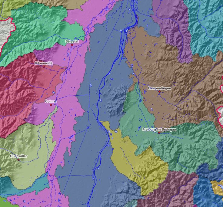
Bassins Versant - 2016
Einzugsgebiete - 2016
Watersheds - 2016
Bassins Versant du Rhin Supérieur 01/01/2016
Einzugsgebiete im Oberrheingebiet am 01/01/2016
Simple
-
AlternativtitelAlternate titleAutre titre
-
Bassins Versant - 2016
Einzugsgebiete - 2016
-
Datum (Erstellung)Date (Creation)Date (Création)
- 2016-01-01
-
Datum (Publikation)Date (Publication)Date (Publication)
- 2016-01-01
-
KennungIdentifierIdentifiant
- BassinsVersant_Einzugsgebiet_ETRS89_2016
-
BearbeitungsstatusStatusÉtat
-
AbgeschlossenCompletedTerminé
Kontakt für die Ressource
Point of contact
Contact pour la ressource
-
mri:deliveryPointmri:deliveryPointmri:deliveryPoint
-
100, avenue d'Alsace
-
mri:citymri:citymri:city
-
COLMAR
-
mri:postalCodemri:postalCodemri:postalCode
-
68000
-
mri:countryCountrymri:country
-
FRANCE
-
Räumliche DarstellungsartSpatial representation typeType de représentation spatiale
-
VektorVectorvecteur
Räumliche Auflösung
Spatial resolution
Résolution spatiale
Vergleichsmassstab
Equivalent scale
Fraction représentative
-
MassstabszahlDenominatorDénominateur
- 50000
-
ThematikTopic categoryCatégorie de thème
-
-
L UmweltL EnvironmentL Environnement
-
Ausdehnung
Extent
Étendue
Ausdehnung
Extent
Étendue
Zeitlicher Umfang
Temporal extent
Étendue temporelle
-
ZeitraumTime periodPériode
- 2016-01-01 2020-01-01
Ausdehnung
Extent
Étendue
Ausdehnung
Extent
Étendue
))
-
WartungsintervallMaintenance and update frequencyFréquence de mise à jour
-
Nicht geplantNot plannedNon planifiée
- Keywords
-
-
Données ouvertes
Open-Data
-
-
OrtPlacePosition
-
-
Rhin Supérieur
Oberrhein
-
- GEMET - INSPIRE themes, version 1.0
-
-
Hydrographie
Gewässernetz
Hydrography
-
- GEMET - Concepts, version 2.4
-
-
bassin versant
Gewässereinzugsgebiet
catchment area
-
bassin hydrographique
Hydrographisches Becken
hydrographic basin
-
réseau hydrographique
Hydrographisches Netz
hydrographic network
-
Ressourcenbeschränkungen
Resource constraints
Contraintes sur la ressource
-
NutzungsbeschränkungUse limitationLimitation d'utilisation
-
© OSM contributors + Ajoutez le logo GeoRhena en cas de réutilisation
© OSM contributors + Das GeoRhena Logo verwenden für alle benutzung dieser Daten
Ressourcenbeschränkungen
Resource constraints
Contraintes sur la ressource
-
ZugriffsbeschränkungenAccess constraintsContraintes d'accès
-
Andere BeschränkungenOther restrictionsAutres restrictions
-
NutzungseinschränkungenUse constraintsContraintes d'utilisation
-
Andere BeschränkungenOther restrictionsAutres restrictions
-
Andere EinschränkungenOther constraintsAutres contraintes
-
Pas d'autre limitation
Keine andere Einschränkung
-
SpracheLanguageLangue
- English
-
ZeichenkodierungCharacter encodingEncodage de caractères
-
Utf8UTF8Utf8
-
AbgabeformatDistribution formatFormat de distribution
-
-
Géodonnée au format SHP
GeoDatei im SHP Format
-
Optionen für die digitale Übertragung
Digital transfer options
Options de transfert numérique
-
OnlineOnLine resourceRessource en ligne
-
bassin_versant
Bassins versantsEinzugsgebiete
Optionen für die digitale Übertragung
Digital transfer options
Options de transfert numérique
-
OnlineOnLine resourceRessource en ligne
-
water:bassin_versant
Bassins versantsEinzugsgebiete
-
ErklärungStatementGénéralités sur la provenance
-
© GeoRhena 20162016
© GeoRhena 20162016
-
BezugsebeneHierarchy levelNiveau
-
DatenbestandDatasetJeu de données
Metadata
-
Identifikator des MetadatensatzesMetadata identifierIdentifiant des métadonnées
- aa10583b-ae00-4dca-ad1c-5102d7fb530f
-
SpracheLanguageLangue
- Français
-
ZeichenkodierungCharacter encodingEncodage de caractères
-
Utf8UTF8Utf8
-
SpracheLanguageLangue
- Deutsch
-
ZeichenkodierungCharacter encodingEncodage de caractères
-
Utf8UTF8Utf8
-
SpracheLanguageLangue
- English
-
ZeichenkodierungCharacter encodingEncodage de caractères
-
Utf8UTF8Utf8
Kontaktstelle für Metadaten
Contact
Point de contact des métadonnées
Anwendungsbereich der Metadaten
Type of resource
Type de ressource
-
Domäne der RessourcenanwendungResource scopeDomaine d'application de la ressource
-
DatenbestandDatasetJeu de données
-
Datumsangaben (Aktualisierung)Date info (Revision)Informations de date (Révision)
- 2024-11-04T07:44:32.938756Z
Metadatenstandard
Metadata standard
Norme des métadonnées
-
TitelTitleTitre
-
ISO 19115-3:2018
-
AusgabeEditionÉdition
-
1.0
)))