geocat.ch
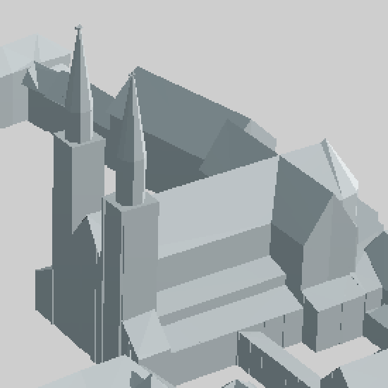
3D-Stadtmodell
Grundrissgerechte Modellierung der Gebäude des Kantons BS mit Gelände. Die Fassaden der Gebäude werden durch die Grundrisse aus den Daten der amtlichen Vermessung gebildet, die bis unter die Dächer hochgezogen sind. Dadurch ergeben sich die Dachüberhänge. Die untere Begrenzung der Gebäude ist der tiefste Punkt, an dem das Gebäude das Geländemodell schneidet. Das Modell wird bezüglich Neubauten laufend nachgeführt.
Die Baummodelle (vereinfacht sowie detailliert) sind aus der LiDAR Befliegung 2021 abgeleitet.
Simple
- Date (Creation)
- 2000-01-01
- Status
- Completed
Owner
- Spatial representation type
- Vector
- Topic category
-
- A Imagery base maps earth cover
Extent
Extent
- Description
-
Canton of Basel-Stadt (BS)
))

- Maintenance and update frequency
- Continual
- geocat.ch
-
-
3D visualisation
-
Resource constraints
- Other constraints
-
Die Geodaten sind öffentlich zugänglich. (Zugangsberechtigungsstufe [A] = öffentlich)
- Other constraints
-
Es gelten die Nutzungsbedingungen für Geodaten des Kantons Basel-Stadt. ( http://www.geo.bs.ch/agb)
Associated resource
- Title
-
3D-Stadtmodell
- Association Type
- Reference to a master resource of which this one is a part
- Language
- Deutsch
- Character encoding
- UTF8
- Subtopic Category
- A1 Base Maps, Landscape Models
- Basic Geodata
- true
- Basic Geodata ID
-
13-BS
- Basic Geodata Legal Level
- Cantonal
- Distribution format
-
-
AutoCAD DXF (DXF)
-
City Geography Markup Language (CityGML)
-
Wavefront (.obj)
-
ESRI Shapefile (SHP)
-
Digital transfer options
- OnLine resource
-
Geodaten-Shop
Öffentlich zugänglicher Geodaten-Downloaddienst des Kantons Basel-Stadt
- Reference system identifier
- CH1903+ / LV95/EPSG: 2056
Metadata
- Metadata identifier
- a7fcab8f-8b17-4559-a77b-ed9f1bef5e1a
- Language
- Deutsch
- Character encoding
- UTF8
- Language
- Français
- Character encoding
- UTF8
- Language
- Italiano
- Character encoding
- UTF8
- Language
- English
- Character encoding
- UTF8
Custodian
Type of resource
- Resource scope
- Dataset
- Metadata linkage
-
https://www.geocat.ch/geonetwork/srv/api/records/a7fcab8f-8b17-4559-a77b-ed9f1bef5e1a
- Date info (Creation)
- 2013-02-05T13:25:15Z
- Date info (Revision)
- 2026-04-13T09:43:58.14931Z
Metadata standard
- Title
-
eCH-0271