 geocat.ch
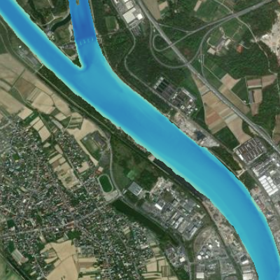
Modèle numérique du fond du Rhin sur une zone d'intérêt
Digitales Geländemodell des Flussbettes des Rheins für ein Untersuchungsgebiet
Digital terrain model for the river Rhine for an area of interest
Cette donnée propose les altitudes absolues du fond du fleuve Rhin. Ces informations ont été générées sur base de relevés bathymétriques et aériens. Elles sont actuellement disponibles sur zone d'intérêt spécifique (AOI) délimitée par les bornes kilométriques 170 et 180. La résolution de ce fichier raster est de 1m. Ne pas utiliser pour la navigation !
Dieser Datensatz stellt die absoluten Höhen des Flussbettes des Rheins dar. Die Informationen sind mittels Vermessungsboot und Befliegung generiert worden. Sie sind in einzelne Untersuchungsgebiete (AOI) aufgeteilt; hier Flusskilometer 170-180. Die Auflösung beträgt 1m. Nicht zur Navigation geeignet !
This data provides the absolute altitudes of the Rhine river bed. This information has been generated on the basis of bathymetric and aerial surveys. It is currently available for the area of specific interest (AOI) delimited by kilometre stones 170 and 180. The resolution of this raster file is 1m. Do not use for navigation !
Simple
-
Datum (Erstellung)Date (Creation)Date (Création)
- 2023-07-10
-
Datum (Publikation)Date (Publication)Date (Publication)
- 2023-08-28
-
KennungIdentifierIdentifiant
- AOI_dem_rhin
-
BearbeitungsstatusStatusÉtat
-
AbgeschlossenCompletedTerminé
Kontakt für die Ressource
Point of contact
Contact pour la ressource
-
mri:deliveryPointmri:deliveryPointmri:deliveryPoint
-
100, avenue d'Alsace
100, avenue d'Alsace
-
mri:citymri:citymri:city
-
COLMAR
-
mri:postalCodemri:postalCodemri:postalCode
-
68000
-
mri:countryCountrymri:country
-
FRANCE
FRANCE
-
mri:electronicMailAddressmri:electronicMailAddressmri:electronicMailAddress
Kontakt für die Ressource
Point of contact
Contact pour la ressource
Kontakt für die Ressource
Point of contact
Contact pour la ressource
-
Räumliche DarstellungsartSpatial representation typeType de représentation spatiale
-
Raster, GitterGridgrille
Räumliche Auflösung
Spatial resolution
Résolution spatiale
Vergleichsmassstab
Equivalent scale
Fraction représentative
-
MassstabszahlDenominatorDénominateur
- 1
-
ThematikTopic categoryCatégorie de thème
-
-
I BinnengewässerI Inland watersI Eaux intérieures
-
Ausdehnung
Extent
Étendue
Ausdehnung
Extent
Étendue
Zeitlicher Umfang
Temporal extent
Étendue temporelle
-
ZeitraumTime periodPériode
- 2003-01-01 2010-12-31
Ausdehnung
Extent
Étendue
Ausdehnung
Extent
Étendue
))
-
WartungsintervallMaintenance and update frequencyFréquence de mise à jour
-
Nicht geplantNot plannedNon planifiée
- Keywords
-
-
Rhin Supérieur
Oberrhein
Upper Rhine
-
rivière
Fluss
River
-
Bathymétrie
Bathymetrie
Bathymetry
-
fond
Gewässersohle
channel
-
relief
Flussrelief
-
- GEMET - Concepts, version 2.4
-
-
relief
Relief
relief (land)
-
fleuve
Fluß
river
-
canalisation de fleuves ou de rivières
Flußregulierung
river channelling
-
Ressourcenbeschränkungen
Resource constraints
Contraintes sur la ressource
-
NutzungsbeschränkungUse limitationLimitation d'utilisation
-
Licence CC BY
CC BY-Lizenz
CC BY Licence
Ressourcenbeschränkungen
Resource constraints
Contraintes sur la ressource
-
ZugriffsbeschränkungenAccess constraintsContraintes d'accès
-
Andere BeschränkungenOther restrictionsAutres restrictions
-
NutzungseinschränkungenUse constraintsContraintes d'utilisation
-
Andere BeschränkungenOther restrictionsAutres restrictions
-
Andere EinschränkungenOther constraintsAutres contraintes
-
Pas d'autre limitation; GeoNutzV §2 et §3 , GeoZG
Keine andere Einschränkung; GeoNutzV §2 und §3 , GeoZG
No other limitation ; GeoNutzV §2 and §3 , GeoZG
-
SpracheLanguageLangue
- Français
-
ZeichenkodierungCharacter encodingEncodage de caractères
-
Utf8UTF8Utf8
-
AbgabeformatDistribution formatFormat de distribution
-
-
Géodonnée au format raster
Raster Geodata
Raster Geodata
-
Optionen für die digitale Übertragung
Digital transfer options
Options de transfert numérique
-
OnlineOnLine resourceRessource en ligne
-
AOI_dem_rhin
AOI_dem_rhin
AOI_dem_rhin
Modèle numérique du fond du RhinDigitales Geländemodell des Flussbettes des RheinsDigital terrain model of the Rhine riverbed
-
BezugsebeneHierarchy levelNiveau
-
DatenbestandDatasetJeu de données
-
ErklärungStatementGénéralités sur la provenance
-
Les données d'origine ont été fournies par la BFG (gestionnaire) et sont la propriété de la WSV (propriétaire). Elles étaient sous forme de .xyz et concernaient une zone un peu plus large que celle du Rhin. GeoRhena a effectué les traitements suivants : assemblage, découpage, reprojection et création d'un modèle numérique de terrain.
Attention! le système de référence altimétrique d'origine est maintenant obsolète. Il s'agit du DHHN92.
Avec nos remerciements pour la Wasserstraßen- und Schifffahrtsverwaltung et le Bundesanstalt für Gewässerkunde.
Die Originaldaten wurden vom BfG zur Verfügung gestellt. Eigentümerin ist die WSV. Der gesamtdatensatz liegt im .xyz-Format vor und hat eine etwas grössere Ausdehnung als der Rhein. GeoRhena hat folgende Prozesse durchgeführt: Zusammenfügen; Beschneiden, Reprojektion und Erstellung eines Geländemodels.
Hinweis: die Daten liegen in einem veralteten Höhensystem vor: DHHN92.
Mit bestem Dank an die Wasserstraßen- und Schifffahrtsverwaltung und das Bundesanstalt für Gewässerkunde.
The original data was supplied by the BFG (manager) and is the property of the WSV (owner). They were in .xyz format and covered an area slightly larger than that of the Rhine. GeoRhena carried out the following processing: assembly, cutting, reprojection and creation of a digital elevation model.
Please note: the original height reference system is now obsolete. It is DHHN92.
With thanks to the Wasserstraßen- und Schifffahrtsverwaltung and the Bundesanstalt für Gewässerkunde.
-
BezugsebeneHierarchy levelNiveau
-
DatenbestandDatasetJeu de données
Metadata
-
Identifikator des MetadatensatzesMetadata identifierIdentifiant des métadonnées
- a549b16c-e8a2-40df-9fce-f43ad2ca945a
-
SpracheLanguageLangue
- Français
-
ZeichenkodierungCharacter encodingEncodage de caractères
-
Utf8UTF8Utf8
-
SpracheLanguageLangue
- Deutsch
-
ZeichenkodierungCharacter encodingEncodage de caractères
-
Utf8UTF8Utf8
-
SpracheLanguageLangue
- English
-
ZeichenkodierungCharacter encodingEncodage de caractères
-
Utf8UTF8Utf8
Kontaktstelle für Metadaten
Contact
Point de contact des métadonnées
-
mdb:deliveryPointmdb:deliveryPointmdb:deliveryPoint
-
100, avenue d'Alsace
100, avenue d'Alsace
-
mdb:citymdb:citymdb:city
-
COLMAR
-
mdb:postalCodemdb:postalCodemdb:postalCode
-
68000
-
mdb:countrymdb:countrymdb:country
-
FR
FR
-
mdb:electronicMailAddressmdb:electronicMailAddressmdb:electronicMailAddress
Anwendungsbereich der Metadaten
Type of resource
Type de ressource
-
Domäne der RessourcenanwendungResource scopeDomaine d'application de la ressource
-
DatenbestandDatasetJeu de données
-
Datumsangaben (Aktualisierung)Date info (Revision)Informations de date (Révision)
- 2023-08-29T08:17:27.0046Z
Metadatenstandard
Metadata standard
Norme des métadonnées
-
TitelTitleTitre
-
ISO 19115-3:2018
-
AusgabeEditionÉdition
-
1.0
)))