 geocat.ch
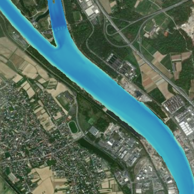
Digital terrain model for the river Rhine for an area of interest
This data provides the absolute altitudes of the Rhine river bed. This information has been generated on the basis of bathymetric and aerial surveys. It is currently available for the area of specific interest (AOI) delimited by kilometre stones 170 and 180. The resolution of this raster file is 1m. Do not use for navigation !
Simple
- Date (Creation)
- 2023-07-10
- Date (Publication)
- 2023-08-28
- Identifier
- AOI_dem_rhin
- Status
- Completed
Point of contact
- mri:deliveryPoint
-
100, avenue d'Alsace
- mri:city
-
COLMAR
- mri:postalCode
-
68000
- Country
-
FRANCE
- mri:electronicMailAddress
Point of contact
- mri:electronicMailAddress
- Spatial representation type
- Grid
Spatial resolution
Equivalent scale
- Denominator
- 1
- Topic category
-
- I Inland waters
Extent
Extent
Temporal extent
- Time period
- 2003-01-01 2010-12-31
Extent
Extent
))
- Maintenance and update frequency
- Not planned
- Keywords
-
-
Upper Rhine
-
River
-
Bathymetry
-
channel
-
relief
-
- GEMET - Concepts, version 2.4
-
-
relief (land)
-
river
-
river channelling
-
Resource constraints
- Use limitation
-
CC BY Licence
Resource constraints
- Access constraints
- Other restrictions
- Use constraints
- Other restrictions
- Other constraints
-
No other limitation ; GeoNutzV §2 and §3 , GeoZG
- Language
- Français
- Character encoding
- UTF8
- Distribution format
-
-
Raster Geodata
-
Digital transfer options
- OnLine resource
-
AOI_dem_rhin
Digital terrain model of the Rhine riverbed
- Hierarchy level
- Dataset
- Statement
-
The original data was supplied by the BFG (manager) and is the property of the WSV (owner). They were in .xyz format and covered an area slightly larger than that of the Rhine. GeoRhena carried out the following processing: assembly, cutting, reprojection and creation of a digital elevation model.
Please note: the original height reference system is now obsolete. It is DHHN92.
With thanks to the Wasserstraßen- und Schifffahrtsverwaltung and the Bundesanstalt für Gewässerkunde.
- Hierarchy level
- Dataset
Metadata
- Metadata identifier
- a549b16c-e8a2-40df-9fce-f43ad2ca945a
- Language
- Français
- Character encoding
- UTF8
- Language
- Deutsch
- Character encoding
- UTF8
- Language
- English
- Character encoding
- UTF8
Contact
- mdb:deliveryPoint
-
100, avenue d'Alsace
- mdb:city
-
COLMAR
- mdb:postalCode
-
68000
- mdb:country
-
FR
- mdb:electronicMailAddress
Type of resource
- Resource scope
- Dataset
- Date info (Revision)
- 2023-08-29T08:17:27.0046Z
Metadata standard
- Title
-
ISO 19115-3:2018
- Edition
-
1.0
)))