geocat.ch
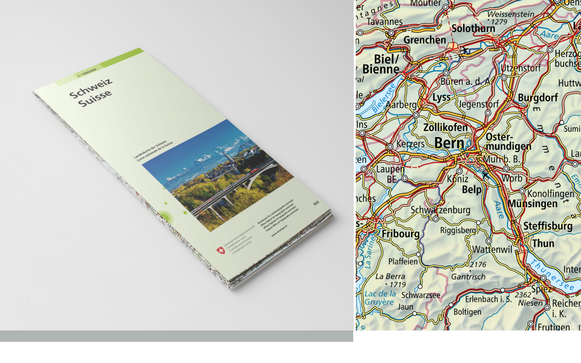
Landeskarte 1:1 Million (grau)
Carte nationale 1:1 million (grise)
Carta nazionale 1:1 milione (grigio)
National Map 1:1 million (grey)
Charta naziunala 1:1 milliun (grisch)
Die Landeskarte 1:1 Milllion (grau) ist eine kleinmassstäbige topografische Übersichtskarte: Die Schweiz und das benachbarte Ausland von Lyon bis Salzburg und von Strassburg bis Genua auf einer handlichen Übersichtskarte. Die Landeskarte 1:1 Million ist in digitaler Form (Swiss Map Raster) und auch als WMTS und WMS Geodienst verfügbar.
La carte nationale au 1:1 million (grise) est une carte topographique synoptique de la Suisse et de l'Europe centrale à petite échelle: La Suisse et les régions limitrophes de Lyon à Salzbourg et de Strasbourg à Gênes sur une carte au format très pratique. La carte nationale au 1:1 million (grise) est disponible sous forme digitale (Swiss Map Raster) et est également disponible en géoservice WMS et WMTS.
La Carta nazionale 1:1 milione (grigio) è una carta sinottica topografica su piccola scala dell'Europa centrale: La Svizzera e i paesi confinanti – da Lione a Salisburgo e da Strasburgo a Genova – in una pratica carta sinottica. La Carta nazionale 1:1 milione (grigio) è disponibile in formato digitale (Swiss Map Raster) ed è inoltre disponibile come geoservizio WMS e WMTS.
The National Map 1:1 million (grey) is a small-scale topographic map giving an overview of Central Europe: Switzerland and its neighbours from Lyons to Salzburg and from Strasbourg to Genoa on a handy overview map (Paris, Vienna, Frankfurt and Marseille on one sheet). The National Map 1:1 million (grey) is published in digital format as the Swiss Map Raster and is also available as WMS or WMTS geoservice.
La Charta naziunala 1:1 milliun (grisch) dat ina survista topografica da l'Europa centrala en ina pitschna scala (Salzburg – Strassburg e Strassbourg – Genua sin in fegl). La Charta naziunala 1:1 milliun (grisch) è disponibla en furma digitala (Swiss Map Raster). El è er disponibel en il geoservetsch WMS e WMTS.
Simple
-
Autre titreAltri nomi o acronimiAlternate titleAlternate titleAlternativtitel
-
Landeskarte 1:1 Million (grau)
Carte nationale 1:1 million (grise)
Carta nazionale 1:1 milione (grigio)
National Map 1:1 million (grey)
Charta naziunala 1:1 miu. (grisch)
-
Date (Création)Data (Creazione)Date (Creation)Date (Creation)Datum (Erstellung)
- 1992-01-01T00:00:00
-
Date (Révision)Data (Revisione)Date (Revision)Date (Revision)Datum (Aktualisierung)
- 2025-01-29
-
IdentifiantIdentificatoreIdentifierIdentifierKennung
- ch.swisstopo.pixelkarte-grau-pk1000.noscale
-
Forme de la présentationForma della presentazionePresentation formPresentation formPräsentationsform
-
Carte numériqueMappa digitaleDigital mapDigital mapDigitale Karte
-
ButScopoPurposePurposeZweck
-
Georeferenzdaten des Bundesrechts
Géodonnées de référence relevant du droit fédéral
Georeferenzdaten des Bundesrechts
-
ÉtatStatoStatusStatusBearbeitungsstatus
-
ContinuIn corsoOn goingOn goingKontinuierliche Aktualisierung
Point de contact
Punto di contatto
Point of contact
Point of contact
Ansprechpartner
Propriétaire
Proprietario
Owner
Owner
Eigentümer
-
Type de représentation spatialeTipo di rappresentazione spazialeSpatial representation typeSpatial representation typeRäumliche Darstellungsart
-
grilleRasterGridGridRaster, Gitter
Résolution spatiale
Risoluzione spaziale
Spatial resolution
Spatial resolution
Räumliche Auflösung
Fraction représentative
Frazione rappresentativa
Equivalent scale
Equivalent scale
Vergleichsmassstab
-
DénominateurDenominatoreDenominatorDenominatorMassstabszahl
- 1000000
-
Catégorie de thèmeCategoria ISOTopic categoryTopic categoryThematik
-
-
A Imagerie, cartes de base et occupation du solA Mappe di base con immagini della copertura terrestreA Imagery base maps earth coverA Imagery base maps earth coverA Oberflächenbeschreibung
-
Étendue
Estensione
Extent
Extent
Ausdehnung
Étendue
Estensione
Extent
Extent
Ausdehnung
-
DescriptionDescrizioneDescriptionDescriptionBeschreibung
-
National map 1:1'000'000
Landeskarte 1:1'000'000
Carte nationale 1:1'000'000
Carta nazionale 1:1'000'000
Landeskarte 1:1'000'000
-
Identifiant géographiqueIdentificatore geograficoGeographic identifierGeographic identifierGeografische Kennung
- NM1000LK1000CN1000CN1000LK1000
))

-
Fréquence de mise à jourFrequenza di aggiornamentoMaintenance and update frequencyMaintenance and update frequencyWartungsintervall
-
IrrégulièreIrregolareIrregularIrregularUnregelmässig
-
Durée de conservationDurata di conservazioneDuration of ConservationDuration of ConservationAufbewahrungsdauer NV in Jahren
- 275
-
Évaluation de la valeur archivistiqueValutazione del valore archivisticoAppraisal of Archival ValueAppraisal of Archival ValueBewertung Archivwürdigkeit
-
AAAAA
-
Raison de la valeur d'archivageMotivo del valore archivisticoReason for Archiving ValueReason for Archiving ValueBegründung Archivwürdigkeit
-
Preuve de la pratique couranteProva della pratica commercialeEvidence of business practiceEvidence of business practiceNachweis der Geschäftspraxis
Format de la ressource
Formato della risorsa
Resource format
Resource format
Format der Ressource
-
TitreTitoloTitleTitleTitel
-
Tagged Image File Format (TIFF)
-
DateDataDateDateDatum
- geocat.ch
-
-
opendata.swiss
opendata.swiss
opendata.swiss
opendata.swiss
-
Planification de la conservation et de l'archivage AAP - Conféderation
Pianificazione della conservazione e dell’archiviazione AAP - Confederazione
Conservation and archiving planning AAP - Confederation
-
carte nationale
carta nazionale
national map
-
réseau de transport
rete di trasporto
traffic network
-
géodonnées de base
geodati di base
official geodata
-
représentation du terrain
rappresentazione del terreno
terrain representation
-
carte générale
carta generale
general map
-
- GEMET
-
-
bordure
frontiera
border
-
eaux (géographie)
acque (geografia)
water (geographic)
-
relief
rilievo
relief (land)
-
cartographie
cartografia
cartography
-
- GEMET - INSPIRE themes, version 1.0
-
-
Dénominations géographiques
Nomi geografici
Geographical names
-
- geocat.ch
-
-
IFDG l’Infrastructure Fédérale de données géographiques
IFDG Infrastruttura federale dei dati geografici
FSDI Federal Spatial Data Infrastructure
-
- geocat.ch
-
-
topographie
topografia
topography
-
- GEMET
-
-
cartogramme
mappa
map chart
-
Contraintes sur la ressource
Vincoli sulle risorse
Resource constraints
Resource constraints
Ressourcenbeschränkungen
-
Autres contraintesAltri vincoliOther constraintsOther constraintsAndere Einschränkungen
- Opendata BY: Freie Nutzung. Quellenangabe ist Pflicht.Opendata BY: Utilisation libre. Obligation d’indiquer la source.Opendata BY: Libero utilizzo. Indicazione della fonte obbligatoria.Opendata BY: Open use. Must provide the source.
Ressource associée
Risorsa associata
Associated resource
Associated resource
Verlinkte Ressource
-
TitreTitoloTitleTitleTitel
-
Landeskartenwerk 1:25'000 bis 1:1 Mio.
Cartes nationales du 1:25'000 au 1:1'000'000
Carte nazionali 1:25'000 – 1:1 mio
-
Type d'associationTipo di associazioneAssociation TypeAssociation TypeAssoziationstyp
-
Citation de travail plus largeCitazione di un'opera più ampiaReference to a master resource of which this one is a partReference to a master resource of which this one is a partÜbergeordneter Datenbestand
-
LangueLinguaLanguageLanguageSprache
- Deutsch
-
Encodage de caractèresCodifica dei caratteriCharacter encodingCharacter encodingZeichenkodierung
-
Utf8UTF8UTF8UTF8Utf8
-
LangueLinguaLanguageLanguageSprache
- Français
-
Encodage de caractèresCodifica dei caratteriCharacter encodingCharacter encodingZeichenkodierung
-
Utf8UTF8UTF8UTF8Utf8
-
LangueLinguaLanguageLanguageSprache
- Italiano
-
Encodage de caractèresCodifica dei caratteriCharacter encodingCharacter encodingZeichenkodierung
-
Utf8UTF8UTF8UTF8Utf8
-
LangueLinguaLanguageLanguageSprache
- Rumantsch
-
Encodage de caractèresCodifica dei caratteriCharacter encodingCharacter encodingZeichenkodierung
-
Utf8UTF8UTF8UTF8Utf8
-
Catégorie de sous-thèmeCategoria di sottotemaSubtopic CategorySubtopic CategoryThematische Unterkategorien
-
A1 Cartes de base, modèles de paysageA1 Mappe di base, modelli paesaggisticiA1 Base Maps, Landscape ModelsA1 Base Maps, Landscape ModelsA1 Basiskarten, Landschaftsmodelle
-
Géodonnées de baseGeodati di baseBasic GeodataBasic GeodataGeobasisdaten
- true
-
Identifiant Géodonnées de baseIdentificativo dei geodati di baseBasic Geodata IDBasic Geodata IDIdentifikator des Geobasisdatensatzes
-
42.6
-
Niveau des géodonnées de baseLivello legale dei geodati di baseBasic Geodata Legal LevelBasic Geodata Legal LevelGeobasisdatenebene
-
FédéralFederaleFederalFederalNational
-
Type de géodonnées de baseTipo di geodati di baseBasic Geodata TypeBasic Geodata TypeGeobasisdatentyp
-
Géodonnées de référenceGeodati di riferimentoReference GeodataReference GeodataGeoreferenzdaten
-
Format de distributionFormato (codifica)Distribution formatDistribution formatAbgabeformat
-
-
Tagged Image File Format (TIFF) Compressed LZW
-
Point de contact
Punto di contatto
Point of contact
Point of contact
Ansprechpartner
Point de contact
Punto di contatto
Point of contact
Point of contact
Ansprechpartner
-
Heures de serviceOrario di servizioHours of serviceHours of serviceBetriebszeiten
-
07h45 - 11h45 / 13h30 - 17h00
Options de transfert numérique
Opzioni di trasferimento digitale
Digital transfer options
Digital transfer options
Optionen für die digitale Übertragung
-
Ressource en ligneRisorsa onlineOnLine resourceOnLine resourceOnline
-
Vorschau map.geo.admin.ch
Vorschau map.geo.admin.ch
-
Ressource en ligneRisorsa onlineOnLine resourceOnLine resourceOnline
-
ch.swisstopo.pixelkarte-grau-pk1000.noscale
Darstellungsdienst WMTS, Layer "Landeskarte 1:1 Million (grau)"Service WMTS, Layer "Carte nationale 1:1 million (gris)"Servizio WMTS, Layer "Carta nazionale 1:1 milione (grigio)Service WMTS, Layer "National Map 1:1 million (grey)"Darstellungsdienst WMTS, Layer "Landeskarte 1:1 Million (grau)"
Options de transfert numérique
Opzioni di trasferimento digitale
Digital transfer options
Digital transfer options
Optionen für die digitale Übertragung
-
Ressource en ligneRisorsa onlineOnLine resourceOnLine resourceOnline
-
ch.swisstopo.pixelkarte-grau-pk1000.noscale
WMS-BGDI Dienst, Layer "Landeskarte 1:1 Million (grau)"Service WMS-IFDG, couche "Carte nationale 1:1 million (grise)"Servizio WMS-IFDG, strato "Carta nazionale 1:1 milione (grigio)"WMS-FSDI service, layer "National Map 1:1 million (grey)"WMS-BGDI Dienst, Layer "Landeskarte 1:1 Million (grau)"
Options de transfert numérique
Opzioni di trasferimento digitale
Digital transfer options
Digital transfer options
Optionen für die digitale Übertragung
-
Ressource en ligneRisorsa onlineOnLine resourceOnLine resourceOnline
-
Produktinformation und Bezug Swiss Map Raster 1000Information du produit et accès Swiss Map Raster 1000Informazioni sul prodotto e accesso a Swiss Map Raster 1000Product info and access to Swiss Map Raster 1000Produktinformation und Bezug Swiss Map Raster 1000
-
Généralités sur la provenanceInformazioni generali sulla provenienzaStatementStatementErklärung
-
Basiert auf der Landesvermessung
Se base sur la Mensuration
Based on the topographic survey
-
NiveauLivelloHierarchy levelHierarchy levelBezugsebene
-
Jeu de donnéesSet di datiDatasetDatasetDatenbestand
-
Nom du système de référenceNome del sistema di riferimentoReference system identifierReference system identifierName des Referenzsystems
- CH1903+
Metadata
-
Identifiant des métadonnéesIdentificativo della schedaMetadata identifierMetadata identifierIdentifikator des Metadatensatzes
- a48eadbc-444d-4c7e-a2c5-10c75ea98b3d
-
LangueLinguaLanguageLanguageSprache
- Deutsch
-
Encodage de caractèresCodifica dei caratteriCharacter encodingCharacter encodingZeichenkodierung
-
Utf8UTF8UTF8UTF8Utf8
-
LangueLinguaLanguageLanguageSprache
- Français
-
Encodage de caractèresCodifica dei caratteriCharacter encodingCharacter encodingZeichenkodierung
-
Utf8UTF8UTF8UTF8Utf8
-
LangueLinguaLanguageLanguageSprache
- Italiano
-
Encodage de caractèresCodifica dei caratteriCharacter encodingCharacter encodingZeichenkodierung
-
Utf8UTF8UTF8UTF8Utf8
-
LangueLinguaLanguageLanguageSprache
- English
-
Encodage de caractèresCodifica dei caratteriCharacter encodingCharacter encodingZeichenkodierung
-
Utf8UTF8UTF8UTF8Utf8
-
LangueLinguaLanguageLanguageSprache
- Rumantsch
-
Encodage de caractèresCodifica dei caratteriCharacter encodingCharacter encodingZeichenkodierung
-
Utf8UTF8UTF8UTF8Utf8
Point de contact
Punto di contatto
Point of contact
Point of contact
Ansprechpartner
-
Heures de serviceOrario di servizioHours of serviceHours of serviceBetriebszeiten
-
08h30 - 11h00 / 14h00 - 16h00 GMT+1
Type de ressource
Tipo di risorsa
Type of resource
Type of resource
Anwendungsbereich der Metadaten
-
Domaine d'application de la ressourceAmbito di applicazione della risorsaResource scopeResource scopeDomäne der Ressourcenanwendung
-
Jeu de donnéesSet di datiDatasetDatasetDatenbestand
-
Lien vers la métadonnéeCollegamento ai metadatiMetadata linkageMetadata linkageLink zu den Metadaten
-
Informations de date (Création)Informazioni sulla data (Creazione)Date info (Creation)Date info (Creation)Datumsangaben (Erstellung)
- 2022-06-17T08:29:06Z
-
Informations de date (Révision)Informazioni sulla data (Revisione)Date info (Revision)Date info (Revision)Datumsangaben (Aktualisierung)
- 2026-05-08T09:06:45.738105Z
Norme des métadonnées
Standard dei metadati
Metadata standard
Metadata standard
Metadatenstandard
-
TitreTitoloTitleTitleTitel
-
eCH-0271