geocat.ch
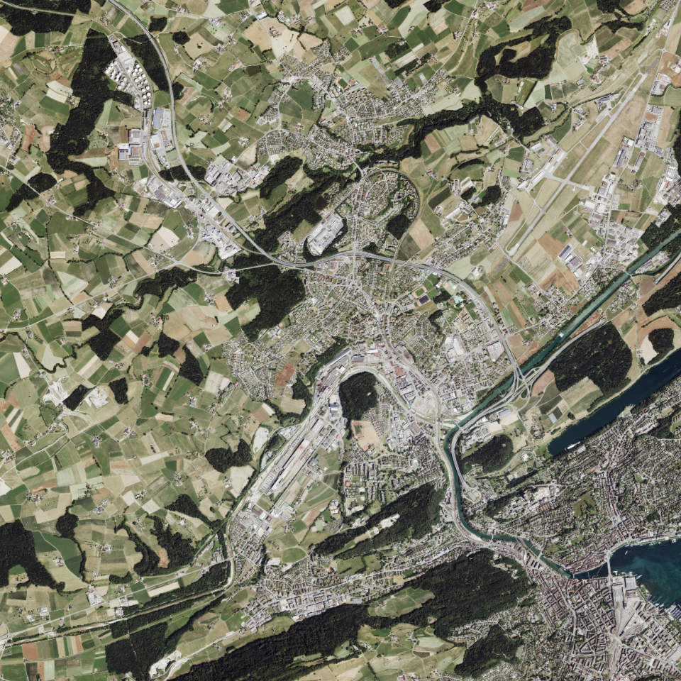
Orthofoto Sommer 2023, 0.08m-Raster
Orthofoto (geometrisch entzerrtes Luftbild) vom Sommer 2023 mit Auflösung von 8cm, inklusive Infrarotbild.
Simple
Informazioni di identificazione
- Titolo alternativo
-
OF23HI08_DS
- Data (Creazione)
- 2024-04-03
- Formato di presentazione
- Mappa digitale
- Finalità
-
Orthofotos werden zu Darstellungs- und Orientierungszwecken verwendet und dienen als Grundlage für Nachführungen oder Auswertungen. Das Orthofoto zeigt den Stand vom Sommer 2023 und liegt über den ganzen Kanton Luzern, mit einer Auflösung von 8 cm, vor. Die Befliegung erfolgte grösstenteils im Juli 2023. Einige höher gelegene Gebiete, wie Pilatus/nördliches Entlebuch, südliches Entlebuch und Rigi erfolgten bereits im Juni 2023.Inklusive Infrarotbild (Band 4)HinweisIm bereitgestellten WMTS-Geodienst ist die Infrarot-Information (Band 4) nicht enthalten.
- Status
- Completato
Punto di contatto
Servizio responsabile
- Nome dell'ente
-
Kanton Luzern, Abteilung Geoinformation
- Telefono
-
041 228 51 83
Indirizzo
- Risorsa online
- https://geoportal.lu.ch/ ( https )
- Ruolo
- Publisher
Punto di contatto
Servizio responsabile
- Nome dell'ente
-
Dienststelle Raum und Wirtschaft (rawi)
- Telefono
-
041 228 51 83
Indirizzo
- Risorsa online
- https://geoportal.lu.ch ( https )
- Ruolo
- Owner
- Cognome
-
Dienststelle Raum und Wirtschaft (rawi)
- Abbreviazione dell'organizzazione
-
rawi
- Frequenza di aggiornamento
- Non pianificato
-
geocat.ch
-
-
opendata.swiss
-
Fernerkundung
-
Luftbild
-
Orthophoto
-
Referenzsystem
-
- Vincoli di accesso
- none
- Vincoli di fruibilità
- Proprietà intellettuale dei dati
- Limitazione d’uso
-
öffentlich zugängliche Geobasisdaten
- Vincoli di accesso
- none
- Vincoli di fruibilità
- none
- Limitazione d’uso
-
Freie Nutzung. Quellenangabe ist Pflicht
- Identificatore aggregato del dataset
- fbe1b292-44af-484d-b65e-f250ad0e2d58
- Tipo di associazione
- Larger work citation
- Identificatore aggregato del dataset
- d8f9e4d5-de31-4d11-9142-63693781b06f
- Tipo di associazione
- Larger work citation
- Identificatore aggregato del dataset
- f86dc990-6ca8-4956-8c75-3ac360e5920e
- Tipo di associazione
- Larger work citation
- Identificatore aggregato del dataset
- 4444f424-3ac9-44a0-a983-e92f5262de15
- Tipo di associazione
- Larger work citation
- Tipo di rappresentazione spaziale
- Dati raster
- Lingua dei metadati
- Deutsch
- Set dei caratteri dei metadati
- UTF8
- Tema
-
- A Carte di base, copertura del suolo, immagini aeree
- A3 Immagini aeree e satellitari
- Descrizione
-
Kanton Luzern
))
- Formato di distribuzione
-
-
Tagged Image File Format (.tif)
(
6.0
)
-
Tagged Image File Format (.tif)
(
6.0
)
Distributore
Servizio responsabile
- Nome dell'ente
-
Dienststelle Raum und Wirtschaft (rawi)
- Telefono
-
041 228 51 83
Indirizzo
- Risorsa online
- https://geoportal.lu.ch ( https )
- Ruolo
- Point of contact
- Nome
-
Geodaten
- Cognome
-
Kanton Luzern
- Abbreviazione dell'organizzazione
-
rawi
- Risorsa online
-
Datenshop
(
https
)
Produktansicht Geodatenshop
- Livello
- Set di dati
- Genealogia del dato – Processo di produzione
-
unbekannt
- Identificatore del sistema di riferimento
- CH1903+
Informazioni sul contenuto
Metadata
- Lingua dei metadati
- Deutsch
- Set dei caratteri dei metadati
- UTF8
- Livello gerarchico
- Set di dati
- Data dei metadati
- 2025-09-03
- Nome dello Standard dei metadati
-
GM03 2+
Contatto
Servizio responsabile
- Nome dell'ente
-
Dienststelle Raum und Wirtschaft (rawi)
- Telefono
-
041 228 51 83
Indirizzo
- Città
-
Luzern
- Codice postale
-
6002
- Nazione
-
CH
- Via
-
Murbacherstrasse
- Numero
-
21
- Risorsa online
- https://geoportal.lu.ch ( https )
- Ruolo
- Point of contact
- Nome
-
Jonas
- Cognome
-
Thalmann
- Abbreviazione dell'organizzazione
-
rawi
- Frequenza di aggiornamento
- Non pianificato