geocat.ch
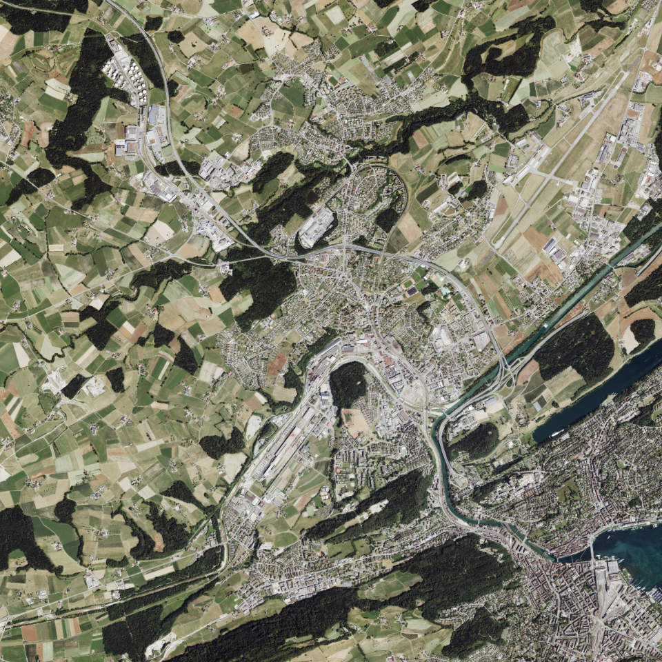
Orthofoto Sommer 2023, 0.08m-Raster
Orthofoto (geometrisch entzerrtes Luftbild) vom Sommer 2023 mit Auflösung von 8cm, inklusive Infrarotbild.
Simple
Identification info
- Alternate title
-
OF23HI08_DS
- Date (Creation)
- 2024-04-03
- Presentation form
- Digital map
- Purpose
-
Orthofotos werden zu Darstellungs- und Orientierungszwecken verwendet und dienen als Grundlage für Nachführungen oder Auswertungen. Das Orthofoto zeigt den Stand vom Sommer 2023 und liegt über den ganzen Kanton Luzern, mit einer Auflösung von 8 cm, vor. Die Befliegung erfolgte grösstenteils im Juli 2023. Einige höher gelegene Gebiete, wie Pilatus/nördliches Entlebuch, südliches Entlebuch und Rigi erfolgten bereits im Juni 2023.Inklusive Infrarotbild (Band 4)HinweisIm bereitgestellten WMTS-Geodienst ist die Infrarot-Information (Band 4) nicht enthalten.
- Status
- Completed
Point of contact
Responsible party
- Organisation name
-
Kanton Luzern, Abteilung Geoinformation
- Voice
-
041 228 51 83
Address
- City
-
Luzern
- Postal code
-
6002
- Country
-
CH
- Electronic mail address
- Streetname
-
Murbacherstrasse
- Streetnumber
-
21
- Website
- https://geoportal.lu.ch/ ( https )
- Role
- Publisher
Point of contact
Responsible party
- Organisation name
-
Dienststelle Raum und Wirtschaft (rawi)
- Voice
-
041 228 51 83
Address
- City
-
Luzern
- Postal code
-
6002
- Country
-
CH
- Electronic mail address
- Streetname
-
Murbacherstrasse
- Streetnumber
-
21
- Website
- https://geoportal.lu.ch ( https )
- Role
- Owner
- Last Name
-
Dienststelle Raum und Wirtschaft (rawi)
- Organisation Acronym
-
rawi
- Maintenance and update frequency
- Not planned
-
geocat.ch
-
-
opendata.swiss
-
Fernerkundung
-
Luftbild
-
Orthophoto
-
Referenzsystem
-
- Access constraints
- none
- Use constraints
- Copyright
- Use limitation
-
öffentlich zugängliche Geobasisdaten
- Access constraints
- none
- Use constraints
- none
- Use limitation
-
Freie Nutzung. Quellenangabe ist Pflicht
- Aggregate Datasetindentifier
- fbe1b292-44af-484d-b65e-f250ad0e2d58
- Association Type
- Larger work citation
- Aggregate Datasetindentifier
- d8f9e4d5-de31-4d11-9142-63693781b06f
- Association Type
- Larger work citation
- Aggregate Datasetindentifier
- f86dc990-6ca8-4956-8c75-3ac360e5920e
- Association Type
- Larger work citation
- Aggregate Datasetindentifier
- 4444f424-3ac9-44a0-a983-e92f5262de15
- Association Type
- Larger work citation
- Spatial representation type
- Grid
- Language
- Deutsch
- Character set
- UTF8
- Topic category
-
- A Base Maps, Land Cover, Aerial and Satellite Imagery
- A3 Aerial and Satellite Imagery
- Description
-
Kanton Luzern
))
- Distribution format
-
-
Tagged Image File Format (.tif)
(
6.0
)
-
Tagged Image File Format (.tif)
(
6.0
)
Distributor contact
Responsible party
- Organisation name
-
Dienststelle Raum und Wirtschaft (rawi)
- Voice
-
041 228 51 83
Address
- City
-
Luzern
- Postal code
-
6002
- Country
-
CH
- Electronic mail address
- Streetname
-
Murbacherstrasse
- Streetnumber
-
21
- Website
- https://geoportal.lu.ch ( https )
- Role
- Point of contact
- First Name
-
Geodaten
- Last Name
-
Kanton Luzern
- Organisation Acronym
-
rawi
- OnLine resource
-
Datenshop
(
https
)
Produktansicht Geodatenshop
- Hierarchy level
- Dataset
- Statement
-
unbekannt
- Reference system identifier
- CH1903+
Content Information
Metadata
- Metadata language
- Deutsch
- Character set
- UTF8
- Hierarchy level
- Dataset
- Date stamp
- 2025-09-03
- Metadata standard name
-
GM03 2+
Metadata author
Responsible party
- Organisation name
-
Dienststelle Raum und Wirtschaft (rawi)
- Voice
-
041 228 51 83
Address
- City
-
Luzern
- Postal code
-
6002
- Country
-
CH
- Electronic mail address
- Streetname
-
Murbacherstrasse
- Streetnumber
-
21
- Website
- https://geoportal.lu.ch ( https )
- Role
- Point of contact
- First Name
-
Jonas
- Last Name
-
Thalmann
- Organisation Acronym
-
rawi
- Maintenance and update frequency
- Not planned