geocat.ch
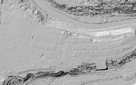
Digitales Geländemodell (DTM) 2023
Digitales Raster-Geländemodell (DTM) der Stadt Bern mit einer Auflösung von 25cm pro Pixel.
Simple
- Date (Revision)
- 2023-06-02
- Status
- Completed
Publisher
Owner
- Topic category
-
- C Elevation
- A Imagery base maps earth cover
Extent
Extent
- Description
-
Stadt Bern
N
S
E
W
))

- Maintenance and update frequency
- Not planned
- geocat.ch
-
-
Höhenmodell
-
Laserscanning
-
opendata.swiss
-
Resource constraints
- Use limitation
-
Zugangsberechtigungsstufe A: öffentlich zugänglich. Es gelten die Nutzungsbedingungen der Stadt Bern ( https://www.bern.ch/nutzungsbedingungen-geodaten).
- Language
- Deutsch
- Character encoding
- UTF8
- Subtopic Category
- A1 Base Maps, Landscape Models
- Distribution format
-
-
GeoTIFF
-
Distributor
Digital transfer options
- OnLine resource
-
Geoportal
Link zur Detailseite vom Geoportal der Stadt Bern.
Digital transfer options
- OnLine resource
-
DTM_2023
Web Map Services WMS
Digital transfer options
- OnLine resource
-
WMTS DTM_2023
Web Map Tile Services WMTS
Digital transfer options
- OnLine resource
-
Permalink opendata.swiss
Permalink opendata.swiss
- Reference system identifier
- EPSG:2056
Metadata
- Metadata identifier
- a2700bca-f7cc-4ae2-84f0-b542fbfa9048
- Language
- Deutsch
- Character encoding
- UTF8
Custodian
Type of resource
- Resource scope
- Dataset
- Date info (Creation)
- 2026-06-20T10:45:50
Metadata standard
- Title
-
GM03 2+