geocat.ch
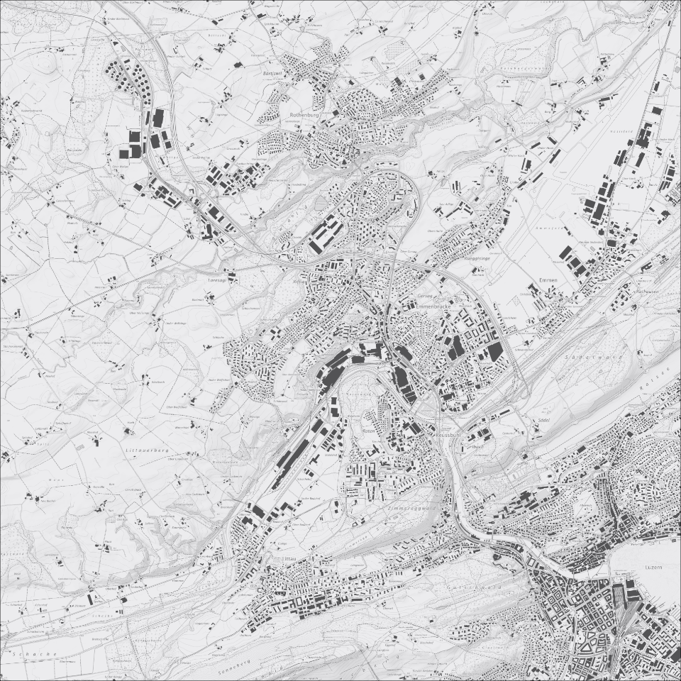
Übersichtsplan 1:10'000 (UP10), mit schattiertem Relief
Übersichtsplan 1:10'000, Graustufen, mit schattiertem Relief: geometrischer Plan im Massstab 1:10'000, der wenig generalisiert ist. Der Übersichtsplan schliesst die Lücke zwischen dem Landeskartenwerk und dem Grundbuchplan.
Simple
Informazioni di identificazione
- Titolo alternativo
-
UP10RELI_DS
- Data (Creazione)
- 2025-11-11
- Formato di presentazione
- Mappa digitale
- Finalità
-
Übersichtsplan aus Daten der Amtlichen Vermessung kombiniert mit geglättetem schattiertem Terrainmodell abgeleitet aus dem DTM-AV (2002/03). Das topographische Planwerk enthält Gebäude, Strassen und Wege, Eisenbahnen, Gewässer, Wald, Höhenlinien und -koten, Lokalnamen und weitere Informationen. Der Übersichtsplan wird für den Massstab 1:10`000 erstellt und liegt flächendeckend in digitaler Form vor.
Neben der schwarz-weissen Version wird vom Übersichtsplan auch eine farbige Version erstellt. Damit eignet er sich einerseits für die Überlagerung mit thematischen Plänen (wie zum Beispiel dem Zonenplan), andererseits auch als eigenständige topografische Karte. Die Aktualisierung erfolgt automatisiert, anhand der Daten der amtlichen Vermessung und Zusatzdaten.
- Status
- In corso
Punto di contatto
Servizio responsabile
- Nome dell'ente
-
Kanton Luzern, Abteilung Geoinformation
- Telefono
-
041 228 51 83
Indirizzo
- Risorsa online
- https://geoportal.lu.ch/ ( https )
- Ruolo
- Publisher
Punto di contatto
Servizio responsabile
- Nome dell'ente
-
Dienststelle Raum und Wirtschaft (rawi)
- Telefono
-
041 228 51 83
Indirizzo
- Risorsa online
- https://geoportal.lu.ch ( https )
- Ruolo
- Owner
- Cognome
-
Dienststelle Raum und Wirtschaft (rawi)
- Abbreviazione dell'organizzazione
-
rawi
- Frequenza di aggiornamento
- Semestrale
-
geocat.ch
-
-
opendata.swiss
-
Amtliche Vermessung/AV
-
Basiskarte
-
Geländemodell
-
Referenzsystem
-
Topographie
-
Kartenwerk
-
- Vincoli di accesso
- none
- Vincoli di fruibilità
- Proprietà intellettuale dei dati
- Limitazione d’uso
-
öffentlich zugängliche Geobasisdaten
- Vincoli di accesso
- none
- Vincoli di fruibilità
- none
- Limitazione d’uso
-
Freie Nutzung. Quellenangabe ist Pflicht
- Identificatore aggregato del dataset
- f39e3c03-a4b6-4d2c-8435-c3fe7426360f
- Tipo di associazione
- Larger work citation
- Tipo di rappresentazione spaziale
- Dati raster
- Denominatore
- 10000
- Lingua dei metadati
- Deutsch
- Set dei caratteri dei metadati
- UTF8
- Tema
-
- A Carte di base, copertura del suolo, immagini aeree
- A1 Carte di base, modelli del territorio
- Descrizione
-
Kanton Luzern
))
- Formato di distribuzione
-
-
Tagged Image File Format (.tif)
(
6.0
)
-
Tagged Image File Format (.tif)
(
6.0
)
Distributore
Servizio responsabile
- Nome dell'ente
-
Dienststelle Raum und Wirtschaft (rawi)
- Telefono
-
041 228 51 83
Indirizzo
- Risorsa online
- https://geoportal.lu.ch ( https )
- Ruolo
- Point of contact
- Nome
-
Geodaten
- Cognome
-
Kanton Luzern
- Abbreviazione dell'organizzazione
-
rawi
- Risorsa online
-
Datenshop
(
https
)
Produktansicht Geodatenshop
- Livello
- Set di dati
- Genealogia del dato – Processo di produzione
-
Abgeleitet von: DTM-AV, ÜP
- Genealogia del dato – Processo di produzione
-
Grundlagen: DTM 2002, UP10
- Identificatore del sistema di riferimento
- CH1903+
Informazioni sul contenuto
Metadata
- Lingua dei metadati
- Deutsch
- Set dei caratteri dei metadati
- UTF8
- Livello gerarchico
- Set di dati
- Data dei metadati
- 2025-11-22
- Nome dello Standard dei metadati
-
GM03 2+
Contatto
Servizio responsabile
- Nome dell'ente
-
Dienststelle Raum und Wirtschaft (rawi)
- Telefono
-
041 228 51 83
Indirizzo
- Città
-
Luzern
- Codice postale
-
6002
- Nazione
-
CH
- Via
-
Murbacherstrasse
- Numero
-
21
- Risorsa online
- https://geoportal.lu.ch ( https )
- Ruolo
- Point of contact
- Nome
-
Dilara
- Cognome
-
Bingül
- Abbreviazione dell'organizzazione
-
rawi
- Frequenza di aggiornamento
- Secondo necessità