geocat.ch
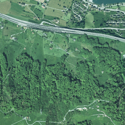
Orthofoto Lothar 2001 (Beckenried, NW)
Der Geobasisdatensatz umfasst ein Luftbild mit den Auswirkungen des Lothars in Beckenried, welches mit Hilfe eines Höhenmodells entzerrt und auf das Landeskoordinatensystem georeferenziert wurde. Das Orthofoto ist vom Jahr 2001 und in der Auflösung von 50cm.
Simple
- Date (Creation)
- 2001-07-17
- Identifier
- 2001_NW_Lothar_50cm
- Status
- Completed
Owner
- Spatial representation type
- Grid
- Topic category
-
- A Imagery base maps earth cover
Extent
Extent
- Description
-
Beckenried
N
S
E
W
))

- Maintenance and update frequency
- Not planned
- GEMET
-
-
aerial photograph
-
aerial photography
-
satellite image
-
- geocat.ch
-
-
orthophoto
-
Resource constraints
- Access constraints
- Other restrictions
- Use constraints
- Other restrictions
- Other constraints
- Die Geodaten sind öffentlich zugänglich (Zugangsberechtigungsstufe A gemäss GeoIV Art. 21).
- Language
- Deutsch
- Character encoding
- UTF8
- Environment description
-
Extern
- Subtopic Category
- A3 Aerial and Satellite Imagery
- Basic Geodata
- false
- Distribution format
-
-
Tagged Image File Format (TIFF)
-
andere Formate auf Anfrage
-
Distributor
Identifier
- Code
- 2056
Metadata
- Metadata identifier
- EDCDF303-5D61-4AAD-A8F2-EB09B5F9DAD1
- Language
- Deutsch
- Character encoding
- UTF8
- Language
- Français
- Character encoding
- UTF8
- Language
- English
- Character encoding
- UTF8
- Language
- Italiano
- Character encoding
- UTF8
Custodian
Type of resource
- Resource scope
- Dataset
- Date info (Revision)
- 2026-05-12T10:10:46.000Z
Metadata standard
- Title
-
GM03_2