 geocat.ch
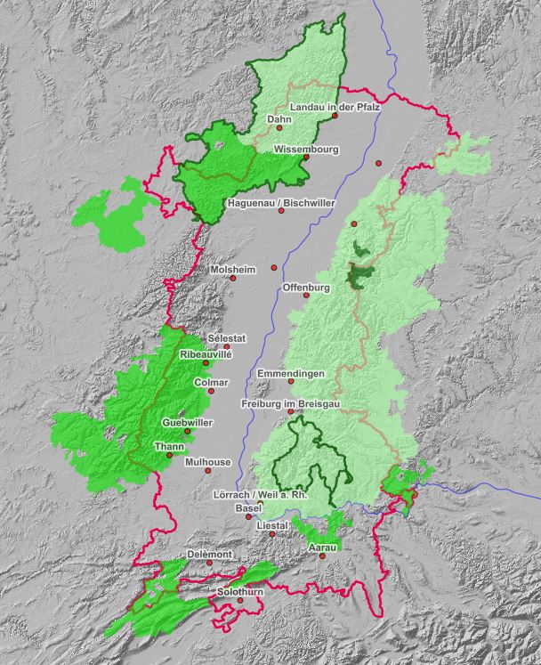
Carte interactive des sites protégés du Rhin Supérieur
Interaktive Karte der Schutzgebiete am Oberrhein
Interactive map of protected areas in the Upper Rhine
Carte interactive intégrant les différentes données à propos des sites naturels protégés sur le territoire du Rhin Supérieur.
Interaktive Karte, die die verschiedenen Daten über die Naturschutzgebiete am Oberrhein zusammenfasst.
Interactive map integrating the different data about the protected nature sites in the Upper Rhine area.
Simple
-
Datum (Publikation)Date (Publication)Date (Publication)
- 2021-05-11T14:38:13
-
PräsentationsformPresentation formForme de la présentation
-
Digitale KarteDigital mapCarte numérique
-
BearbeitungsstatusStatusÉtat
-
AbgeschlossenCompletedTerminé
-
ThematikTopic categoryCatégorie de thème
-
-
L UmweltL EnvironmentL Environnement
-
Ausdehnung
Extent
Étendue
Ausdehnung
Extent
Étendue
N
S
E
W
))
-
WartungsintervallMaintenance and update frequencyFréquence de mise à jour
-
UnbekanntUnknownInconnue
-
ThemaThemeThème
-
-
parcs;naturels;biosphère;Naturparks ;parks;Biosphärenreservate ;2021;carte;Interaktive;Karte;interactive
-
- GEMET - Concepts, version 2.4
-
-
parc national
Nationalpark
national park
-
parc naturel
Naturpark
natural park
-
parc naturel régional
Regionaler Naturpark
regional natural park
-
biosphère
Biosphäre
biosphere
-
réserve de biosphère
Biosphärenreservat
biosphere reserve
-
-
SpracheLanguageLangue
- Français
-
AbgabeformatDistribution formatFormat de distribution
-
-
OGC:OWS-C
-
Optionen für die digitale Übertragung
Digital transfer options
Options de transfert numérique
-
OnlineOnLine resourceRessource en ligne
-
Ouvrir la carte interactive
Die interaktive Karte öffnen
-
Name des ReferenzsystemsReference system identifierNom du système de référence
- EPSG:3857
Metadata
-
Identifikator des MetadatensatzesMetadata identifierIdentifiant des métadonnées
- 9f70d363-25fe-45a2-8528-89fe2e06eaa4
-
SpracheLanguageLangue
- Français
-
ZeichenkodierungCharacter encodingEncodage de caractères
-
Utf8UTF8Utf8
-
SpracheLanguageLangue
- Deutsch
-
ZeichenkodierungCharacter encodingEncodage de caractères
-
Utf8UTF8Utf8
-
SpracheLanguageLangue
- English
-
ZeichenkodierungCharacter encodingEncodage de caractères
-
Utf8UTF8Utf8
Anwendungsbereich der Metadaten
Type of resource
Type de ressource
-
Domäne der RessourcenanwendungResource scopeDomaine d'application de la ressource
-
interactiveMapinteractiveMapinteractiveMap
-
Datumsangaben (Aktualisierung)Date info (Revision)Informations de date (Révision)
- 2022-09-26T14:43:52.130747Z
Metadatenstandard
Metadata standard
Norme des métadonnées
-
TitelTitleTitre
-
ISO 19115-3:2018
-
AusgabeEditionÉdition
-
1.0
)))