geocat.ch
Simple
-
Date (Revision)
- 1967-01-01
-
Purpose
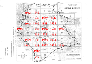
- Der aus insgesamt 28 Einzelblättern bestehende historische Übersichtsplan der Stadt Zürich zeigt einen Teil der Stadt zwischen 1932 und 1961.
Owner
-
Spatial representation type
-
Grid
Spatial resolution
Equivalent scale
-
Denominator
- 5000
-
Topic category
-
-
A Imagery base maps earth cover
-
D Boundaries
-
Extent
Extent
-
Description
-
Stadt Zürich
-
Extent type code
- true

))
-
Maintenance and update frequency
-
Unknown
-
Theme
-
-
Historischer Plan, Historischer Übersichtsplan
-
Resource constraints
-
Use limitation
-
1. Nutzungsbestimmung
Diese Geodaten stehen unter der international gültigen Creative-Commons-Zero-Lizenz (CC-0). Sie dürfen:
- vervielfältigt, verbreitet und weiter zugänglich gemacht werden,
- angereichert und bearbeitet werden,
- kommerziell genutzt werden.
Eine Quellenangabe (CC-BY) wird empfohlen: Sie lautet: „Quelle: Stadt Zürich“.
2. Haftungsausschluss
Die in der Verwaltung der Stadt Zürich zuständige Stelle gemäss Art. 8 Abs. 1 GeoIG (SR 510.62) schliesst jede Haftung für direkte und indirekte Schäden durch die Nutzung der Geodaten [Nutzung der Geodienste] aus. Sie übernimmt keine Garantie für die Aktualität, Richtigkeit, Vollständigkeit und Genauigkeit der veröffentlichten Geodaten.
3. Rahmenbedingungen
- Reglement über offene Verwaltungsdaten, AS 170.410
- Städtisches Geoinformationsreglement (StGeoIR), AS 704.100
-
Language
- deu
-
Character encoding
-
UTF8
-
Included with dataset
- 0
-
Title
-
Historischer Übersichtsplan der Stadt Zürich zwischen 1932 und 1961
-
Date (Revision)
- 1967-01-01
-
Name
-
Historischer Übersichtsplan der Stadt Zürich zwischen 1932 und 1961
-
Date
- 1967-01-01
Property description
-
Property name
- Blatt_17.tif
Property description
-
Property name
- Blatt_54.tif
Property description
-
Property name
- Blatt_05.tif
Property description
-
Property name
- Blatt_33.tif
Property description
-
Property name
- Blatt_28.tif
Property description
-
Property name
- Blatt_46.tif
Property description
-
Property name
- Blatt_45.tif
Property description
-
Property name
- Blatt_47.tif
Property description
-
Property name
- Blatt_31.tif
Property description
-
Property name
- Blatt_39.tif
Property description
-
Property name
- Blatt_27.tif
Property description
-
Property name
- Blatt_38.tif
Property description
-
Property name
- Blatt_19.tif
Property description
-
Property name
- Blatt_32.tif
Property description
-
Property name
- Blatt_43.tif
Property description
-
Property name
- Blatt_25.tif
Property description
-
Property name
- Blatt_11.tif
Property description
-
Property name
- Blatt_50.tif
Property description
-
Property name
- Blatt_44.tif
Property description
-
Property name
- Blatt_18.tif
Property description
-
Property name
- Blatt_20.tif
Property description
-
Property name
- Blatt_37.tif
Property description
-
Property name
- Blatt_40.tif
Property description
-
Property name
- Blatt_08.tif
Property description
-
Property name
- Blatt_23.tif
Property description
-
Property name
- Blatt_13.tif
Property description
-
Property name
- Blatt_26.tif
Property description
-
Property name
- Blatt_12.tif
Digital transfer options
-
OnLine resource
-
Historischer Übersichtsplan der Stadt Zürich zwischen 1932 und 1961 - DatenbezugHistorischer Übersichtsplan der Stadt Zürich zwischen 1932 und 1961 - Distribution des donnéesHistorischer Übersichtsplan der Stadt Zürich zwischen 1932 und 1961 - Procacciamento dei datiHistorischer Übersichtsplan der Stadt Zürich zwischen 1932 und 1961 - Order data
-
Distribution format
-
-
GeoTIFF (.tif)
-
-
Hierarchy level
-
Dataset
-
Geometric object type
-
raster
-
Reference system identifier
- CH1903_LV03
Metadata
-
Metadata identifier
- 9e0ba615-7c9e-4d4b-9bfa-b56fbfdd7dcd
-
Language
- deu
-
Character encoding
-
UTF8
Point of contact
Type of resource
-
Resource scope
-
Dataset
-
Name
-
Historischer Übersichtsplan der Stadt Zürich zwischen 1932 und 1961
-
Date info (Revision)
- 2026-01-06T10:48:41
Metadata standard
-
Title
-
GM03 2+