geocat.ch
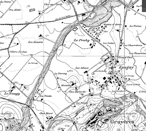
Plan d'ensemble 1990 et 2010
Ce plan topographique archivé offre une représentation du terrain, avec sa végétation, ses ouvrages construits, les courbes de niveau équidistantes de 10 m et la toponymie.
Il se présente sous 2 versions différentes.
Les plans 1:10'000 ont été créés sur film dès 1975 selon les normes fédérales et maintenus en partie à jour jusqu’en 1990.
Les plans 1:5’000 ont été créés sur film par agrandissement photographique de la version 1:10'000 en 1990 et maintenus à jour jusqu’en 2010.
Chaque version est disponible sous la forme d’une image géoréférencée.
Simple
- Alternate title
-
Plan d'ensemble 1:10'000 et 1:5000
- Date (Creation)
- 1970-01-01
- Presentation form
- Digital map
- Status
- Historical archive
Point of contact
- Spatial representation type
- Grid
Spatial resolution
- Spatial resolution
- 0.25 m
- Topic category
-
- A Imagery base maps earth cover
Extent
Extent
- Description
-
Canton of Fribourg (FR)
))

- Maintenance and update frequency
- Not planned
Resource format
- Title
-
Tagged Image File Format (TIFF)
- Date
- geocat.ch
-
-
survey plan
-
- geocat.ch
-
-
historic map
-
Resource constraints
- Other constraints
-
Propriété de l'Etat de Fribourg
- Language
- Français
- Character encoding
- UTF8
- Environment description
-
V:\GEODONNEES\CANTON\SCG\Archives\Plans_d'ensemble_20-21e\PE_10000_1990
- Subtopic Category
- A1 Base Maps, Landscape Models
- Distribution format
-
-
Tagged Image File Format (TIFF)
-
Identifier
- Code
- EPSG:2056
- Description
-
CH1903+ / LV95 (EPSG:2056)
Metadata
- Metadata identifier
- 9d9aacd4-9956-4a2f-9963-121761c180c3
- Language
- Français
- Character encoding
- UTF8
- Language
- Deutsch
- Character encoding
- UTF8
- Language
- English
- Character encoding
- UTF8
- Language
- Italiano
- Character encoding
- UTF8
Point of contact
Type of resource
- Resource scope
- Dataset
- Metadata linkage
-
https://www.geocat.ch/geonetwork/srv/api/records/9d9aacd4-9956-4a2f-9963-121761c180c3
- Date info (Creation)
- 2016-12-19T08:50:55Z
- Date info (Revision)
- 2026-05-27T12:24:28.069209Z
Metadata standard
- Title
-
eCH-0271