geocat.ch
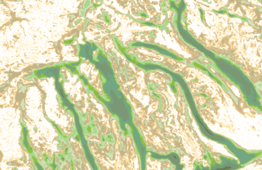
Thickness model of unconsolidated deposits
The national thickness model of unconsolidated deposits describes the thickness of the unconsolidated deposits in meters with a 10 x 10 m raster cell size. This product is derived from the bedrock elevation model. The subtraction of the bedrock surface from the base terrain model provides the thickness of the unconsolidated deposits. The base terrain is a combination of <a href=" https://www.swisstopo.admin.ch/en/height-model-swissalti3d" target="_blank">swissALTI3D</a>, <a href="https://www.swisstopo.admin.ch/en/height-model-swissbathy3d" target="_blank">swissBATHY3D</a> and the <a href="https://www.glamos.ch/en/#/A50d-01" target="_blank">GLAMOS</a> glacier base. The thickness model of unconsolidated deposits is part of the larger swissBEDROCK dataset, which also includes the <a href="https://map.geo.admin.ch/?layers=ch.swisstopo.geologie-felsoberflaeche_hoehenmodell&topic=geol" target="_blank">bedrock elevation model (BEM)</a>, uncertainty estimates, and changes compared to previous versions. The full swissBEDROCK dataset can be <a href=" https://www.swisstopo.admin.ch/en/swissbedrock-en" target="_blank">downloaded here</a> or viewed and queried on <a href="https://viewer.swissgeol.ch/?lon=8.39730&lat=44.63444&elevation=238404&heading=341&pitch=-48&layers=ch.swisstopo.swissbedrock-geotiff%2Cch.swisstopo.swissbedrock-geotiff-with-terrain&layers_transparency=0.5%2C0&layers_visibility=false%2Ctrue&map=empty_map" target="_blank">viewer.swissgeol.ch</a> on a cell basis. The model consists of data provided by third parties and parts that have been modelled by the Federal Office of Topography. A <a href="https://www.geocat.ch/geonetwork/srv/api/records/f7836146-3f9a-4807-9011-618800409236/attachments/swissBEDROCK_ReleaseNotes_R1.pdf?approved=true" target="_blank">release notes</a> file is provided detailing the origin and characteristics of the various model components. More information on the methodological overview and workflow can be found in the <a href="https://www.geocat.ch/geonetwork/srv/api/records/f7836146-3f9a-4807-9011-618800409236/attachments/swissBEDROCK_model_description.pdf?approved=true" target="_blank">model description</a>. 3D models represent a simplification of the real geological settings. The user acknowledges that the authors have taken every reasonable effort to ensure that information contained in the presented 3D geological model is as accurate as possible. There is no guarantee that the given data related to a definite point in the subsurface is accurate. Under no circumstances will the publisher be liable for any loss or damage of a material or immaterial nature arising from access to, use or non-use of published information, or from misuse or technical breakdown .
Simple
- Alternate title
-
Thickness of unconsolidated deposits
- Date (Publication)
- 2015-04-29T11:20:00
- Date (Revision)
- 2025-08-27
- Identifier
- ch.swisstopo.geologie-lockergestein_maechtigkeitsmodell
Owner
- Spatial representation type
- Grid
- Topic category
-
- F Geoscientific information
Extent
Extent
- Description
-
Switzerland
))

- Maintenance and update frequency
- Annually
- Duration of Conservation
- 275
- Appraisal of Archival Value
- A
- Reason for Archiving Value
- Evidence of business practice
- Comment on Archival Value
-
Grundlage ist eine Datenbank, Raster-Darstellungen im Internet.
- geocat.ch
-
-
glaciation
-
bouguer anomaly
-
opendata.swiss
-
Conservation and archiving planning AAP - Confederation
-
official geodata
-
- GEMET
-
-
sedimentation basin
-
geomorphology
-
sedimentation (geology)
-
- geocat.ch
-
-
FSDI Federal Spatial Data Infrastructure
-
Resource constraints
- Other constraints
-
NonCommercialAllowed-CommercialAllowed-ReferenceRequired
Associated resource
- Association Type
- Reference to a master resource of which this one is a part
- Metadata Reference
- Language
- Deutsch
- Character encoding
- UTF8
- Language
- Français
- Character encoding
- UTF8
- Subtopic Category
- F1 Geology
- Basic Geodata
- true
- Basic Geodata ID
-
47.18
- Basic Geodata Legal Level
- Federal
- Distribution format
-
-
GeoTIFF (GEOTIFF)
-
Digital transfer options
- OnLine resource
-
Vorschau map.geo.admin.ch
Preview map.geo.admin.ch
Digital transfer options
- OnLine resource
-
ch.swisstopo.geologie-lockergestein_maechtigkeitsmodell
WMS-FSDI service, layer "Thickness of unconsolidated deposits"
Digital transfer options
- OnLine resource
-
ch.swisstopo.geologie-lockergestein_maechtigkeitsmodell
WMTS-FSDI service, layer "Thickness of unconsolidated deposits"
Digital transfer options
Digital transfer options
Digital transfer options
- OnLine resource
-
RESTful API von geo.admin.ch
RESTful API from geo.admin.ch
Digital transfer options
- OnLine resource
-
viewer.swissgeol.ch
- Statement
-
"Beschreibung der Herkunft"
- Hierarchy level
- Dataset
- Reference system identifier
- Das Modell wird in schweizerischen Koordinatensystem LV95 LN02 angeboten.
Metadata
- Metadata identifier
- 99eb4571-4c34-48cc-bd6a-32fd9decc2a7
- Language
- Deutsch
- Character encoding
- UTF8
- Language
- Français
- Character encoding
- UTF8
- Language
- Italiano
- Character encoding
- UTF8
- Language
- English
- Character encoding
- UTF8
- Language
- Rumantsch
- Character encoding
- UTF8
Owner
Type of resource
- Resource scope
- Dataset
- Metadata linkage
-
https://www.geocat.ch/geonetwork/srv/api/records/99eb4571-4c34-48cc-bd6a-32fd9decc2a7
- Date info (Creation)
- 2018-11-23T08:04:49Z
- Date info (Revision)
- 2026-05-28T14:13:39.607221Z
Metadata standard
- Title
-
eCH-0271