geocat.ch
Mächtigkeitsmodell des Lockergesteins
Modèle d’épaisseur des terrains meubles
Modello di spessore dei depositi sciolti
Thickness model of unconsolidated deposits
Grossezza da la crappa lucca da la Svizra
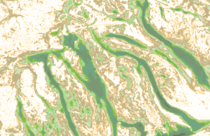
Das nationale Mächtigkeitsmodell des Lockergesteins beschreibt die Mächtigkeit des Lockergesteins in Metern und hat eine Rasterzellengrösse von 10 x 10 m. Dieses Produkt wird aus dem Höhenmodell der Felsoberfläche abgeleitet. Durch Subtraktion des Höhenmodells der Felsoberfläche vom Basis-Geländemodell ergibt die Lockergesteinsmächtigkeit. Das dem Basis-Geländemodell ist eine Kombination aus <a href=" https://www.swisstopo.admin.ch/de/hoehenmodell-swissalti3d" target="_blank">swissALTI3D</a>, <a href="https://www.swisstopo.admin.ch/de/hoehenmodell-swissbathy3d" target="_blank">swissBATHY3D</a> und der <a href="https://www.glamos.ch/#/A50d-01" target="_blank">GLAMOS</a>-Gletscherbasis. Das Mächtigkeitsmodell des Lockergesteins ist Teil des grösseren Datensatzes swissBEDROCK, der auch das <a href="https://map.geo.admin.ch/?layers=ch.swisstopo.geologie-felsoberflaeche_hoehenmodell&topic=geol" target="_blank">Höhenmodell der Felsoberfläche (BEM)</a>, Unsicherheitsschätzungen und Änderungen gegenüber früheren Versionen enthält. Der vollständige Datensatz swissBEDROCK kann <a href=" https://www.swisstopo.admin.ch/de/swissbedrock-de" target="_blank">hier heruntergeladen</a> oder auf <a href="https://viewer.swissgeol.ch/?lon=8.39730&lat=44.63444&elevation=238404&heading=341&pitch=-48&layers=ch.swisstopo.swissbedrock-geotiff%2Cch.swisstopo.swissbedrock-geotiff-with-terrain&layers_transparency=0.5%2C0&layers_visibility=false%2Ctrue&map=empty_map" target="_blank">viewer.swissgeol.ch</a> zellenweise angezeigt und abgefragt werden. Das Modell besteht aus Daten Dritter und aus Teilen, die vom Bundesamt für Landestopografie modelliert wurden. Eine Datei mit <a href="https://www.geocat.ch/geonetwork/srv/api/records/f7836146-3f9a-4807-9011-618800409236/attachments/swissBEDROCK_ReleaseNotes_R1.pdf?approved=true" target="_blank">Versionshinweisen</a> enthält detaillierte Angaben zur Herkunft und zu den Eigenschaften der verschiedenen Modellkomponenten. Weitere Informationen zur Methodik und zum Arbeitsablauf finden Sie in der <a href="https://www.geocat.ch/geonetwork/srv/api/records/f7836146-3f9a-4807-9011-618800409236/attachments/swissBEDROCK_model_description.pdf?approved=true" target="_blank">Modellbeschreibung</a>. 3D-Modelle stellen Vereinfachungen der realen Geologie dar. Der Nutzer anerkennt, dass die Autoren alle zumutbaren Aufwände unternommen haben, um die Informationen im geologischen 3D-Modell zu verifizieren. Es gibt keine Garantie, dass die angegebenen Daten an einem bestimmten Punkt im Untergrund korrekt sind. Der Herausgeber ist unter keinen Umständen für jegliche Verluste oder Schäden materieller oder immaterieller Art haftbar, welche aus dem Zugriff auf, die Nutzung oder Nichtnutzung der veröffentlichen Informationen, durch Missbrauch oder technische Störungen entstehen .
Le modèle national d'épaisseur des terrains meubles décrit l'épaisseur des terrains meubles en mètres avec une taille de cellule de 10 x 10 m. Ce produit est dérivé du modèle d’altitude du toit du rocher. La soustraction de la surface du substratum rocheux du modèle de terrain de base fournit l'épaisseur des terrains meubles. Le terrain de base est une combinaison du <a href=" https://www.swisstopo.admin.ch/fr/modele-altimetrique-swissalti3d" target="_blank">swissALTI3D</a>, <a href="https://www.swisstopo.admin.ch/fr/modele-altimetrique-swissbathy3d" target="_blank">swissBATHY3D</a> et de la surface de base des glaciers <a href="https://www.glamos.ch/fr/#/A50d-01" target="_blank">GLAMOS</a>. Le modèle d'épaisseur des terrains meubles fait partie du jeu de données plus vaste swissBEDROCK, qui comprend également le <a href="https://map.geo.admin.ch/?layers=ch.swisstopo.geologie-felsoberflaeche_hoehenmodell&topic=geol" target="_blank">modèle d’altitude du toit du rocher (BEM)</a>, des indications sur les incertitudes et les changements par rapport aux versions précédentes. L'ensemble complet des données swissBEDROCK peut être <a href=" https://www.swisstopo.admin.ch/fr/swissbedrock-fr" target="_blank">téléchargé ici</a> ou consulté et interrogé cellule par cellule sur <a href="https://viewer.swissgeol.ch/?lon=8.39730&lat=44.63444&elevation=238404&heading=341&pitch=-48&layers=ch.swisstopo.swissbedrock-geotiff%2Cch.swisstopo.swissbedrock-geotiff-with-terrain&layers_transparency=0.5%2C0&layers_visibility=false%2Ctrue&map=empty_map" target="_blank">viewer.swissgeol.ch</a>. Le modèle se compose de données fournies par des tiers et de parties modélisées par l'Office fédéral de topographie. Un fichier de <a href="https://www.geocat.ch/geonetwork/srv/api/records/f7836146-3f9a-4807-9011-618800409236/attachments/swissBEDROCK_ReleaseNotes_R1.pdf?approved=true" target="_blank">notes de version</a> détaillant l'origine et les caractéristiques des différents composants du modèle est fourni. Vous trouverez de plus amples informations sur la méthodologie et le déroulement des travaux dans la <a href="https://www.geocat.ch/geonetwork/srv/api/records/f7836146-3f9a-4807-9011-618800409236/attachments/swissBEDROCK_model_description.pdf?approved=true" target="_blank">description du modèle</a>. Les modèles 3D représentent des simplifications des paramètres géologiques réels. L'utilisateur reconnaît que les auteurs ont fait tous les efforts raisonnables pour vérifier les informations contenues dans le modèle géologique 3D présenté. Il n'y a aucune garantie que les données soient correctes à un point donné du sous-sol. En aucun cas, l'éditeur ne sera responsable des pertes ou dommages de nature matérielle ou immatérielle résultant de l'accès à l'information publiée, de son utilisation ou de sa non-utilisation, d'une mauvaise utilisation ou de défauts techniques .
Il modello nazionale di spessore dei depositi sciolti fornisce la distribuzione dello spessore dei sedimenti in metri, con una risoluzione di 10 × 10 m per cella raster. Questo prodotto deriva dal modello di elevazione del substrato roccioso: la differenza tra la superficie del substrato e il modello del terreno di base permette infatti di calcolare lo spessore dei depositi sciolti. Il terreno di base è ottenuto dall’integrazione di <a href=" https://www.swisstopo.admin.ch/it/modello-altimetrico-swissalti3d" target="_blank">swissALTI3D</a>, <a href="https://www.swisstopo.admin.ch/it/modello-altimetrico-swissbathy3d" target="_blank">swissBATHY3D</a> e del la base dei ghiacciai <a href="https://www.glamos.ch/it/#/A50d-01" target="_blank">GLAMOS</a>. Il modello di spessore dei depositi sciolti costituisce una parte del dataset più ampio swissBEDROCK, che comprende anche il <a href="https://map.geo.admin.ch/?layers=ch.swisstopo.geologie-felsoberflaeche_hoehenmodell&topic=geol" target="_blank">modello altitudine del tetto del substrato roccioso (BEM)</a> le stime di incertezza e i confronti con le versioni precedenti. L’intero dataset può essere <a href=" https://www.swisstopo.admin.ch/it/swissbedrock-it" target="_blank">scaricato qui</a> o visualizzato e interrogato cella per cella su <a href="https://viewer.swissgeol.ch/?lon=8.39730&lat=44.63444&elevation=238404&heading=341&pitch=-48&layers=ch.swisstopo.swissbedrock-geotiff%2Cch.swisstopo.swissbedrock-geotiff-with-terrain&layers_transparency=0.5%2C0&layers_visibility=false%2Ctrue&map=empty_map" target="_blank">viewer.swissgeol.ch</a>. Il modello integra dati forniti da enti esterni con componenti sviluppati dall’Ufficio federale di topografia. È disponibile un file <a href="https://www.geocat.ch/geonetwork/srv/api/records/f7836146-3f9a-4807-9011-618800409236/attachments/swissBEDROCK_ReleaseNotes_R1.pdf?approved=true" target="_blank">con le note di rilascio della versione</a> che fornisce dettagli sull’origine e le caratteristiche dei diversi componenti del modello. Ulteriori informazioni sulla metodologia e sul flusso di lavoro sono riportate nella <a href="https://www.geocat.ch/geonetwork/srv/api/records/f7836146-3f9a-4807-9011-618800409236/attachments/swissBEDROCK_model_description.pdf?approved=true" target="_blank">descrizione del modello</a>. I modelli 3D rappresentano semplificazioni dei parametri geologici reali. L'utente riconosce che gli autori hanno applicato tutti gli sforzi ragionevoli per verificare le informazioni contenute nel modello geologico 3D presentato. Non c'è alcuna garanzia che i dati siano corretti in qualsiasi punto del sottosuolo. In nessun caso l'editore sarà responsabile per qualsiasi perdita o danno di natura materiale o immateriale derivante dall'accesso, uso o non uso, abuso o difetti tecnici delle informazioni pubblicate .
The national thickness model of unconsolidated deposits describes the thickness of the unconsolidated deposits in meters with a 10 x 10 m raster cell size. This product is derived from the bedrock elevation model. The subtraction of the bedrock surface from the base terrain model provides the thickness of the unconsolidated deposits. The base terrain is a combination of <a href=" https://www.swisstopo.admin.ch/en/height-model-swissalti3d" target="_blank">swissALTI3D</a>, <a href="https://www.swisstopo.admin.ch/en/height-model-swissbathy3d" target="_blank">swissBATHY3D</a> and the <a href="https://www.glamos.ch/en/#/A50d-01" target="_blank">GLAMOS</a> glacier base. The thickness model of unconsolidated deposits is part of the larger swissBEDROCK dataset, which also includes the <a href="https://map.geo.admin.ch/?layers=ch.swisstopo.geologie-felsoberflaeche_hoehenmodell&topic=geol" target="_blank">bedrock elevation model (BEM)</a>, uncertainty estimates, and changes compared to previous versions. The full swissBEDROCK dataset can be <a href=" https://www.swisstopo.admin.ch/en/swissbedrock-en" target="_blank">downloaded here</a> or viewed and queried on <a href="https://viewer.swissgeol.ch/?lon=8.39730&lat=44.63444&elevation=238404&heading=341&pitch=-48&layers=ch.swisstopo.swissbedrock-geotiff%2Cch.swisstopo.swissbedrock-geotiff-with-terrain&layers_transparency=0.5%2C0&layers_visibility=false%2Ctrue&map=empty_map" target="_blank">viewer.swissgeol.ch</a> on a cell basis. The model consists of data provided by third parties and parts that have been modelled by the Federal Office of Topography. A <a href="https://www.geocat.ch/geonetwork/srv/api/records/f7836146-3f9a-4807-9011-618800409236/attachments/swissBEDROCK_ReleaseNotes_R1.pdf?approved=true" target="_blank">release notes</a> file is provided detailing the origin and characteristics of the various model components. More information on the methodological overview and workflow can be found in the <a href="https://www.geocat.ch/geonetwork/srv/api/records/f7836146-3f9a-4807-9011-618800409236/attachments/swissBEDROCK_model_description.pdf?approved=true" target="_blank">model description</a>. 3D models represent a simplification of the real geological settings. The user acknowledges that the authors have taken every reasonable effort to ensure that information contained in the presented 3D geological model is as accurate as possible. There is no guarantee that the given data related to a definite point in the subsurface is accurate. Under no circumstances will the publisher be liable for any loss or damage of a material or immaterial nature arising from access to, use or non-use of published information, or from misuse or technical breakdown .
Simple
-
Autre titreAltri nomi o acronimiAlternate titleAlternate titleAlternativtitel
-
Mächtigkeit des Lockergesteins
Épaisseur des terrains meubles
Spessore dei depositi sciolti
Thickness of unconsolidated deposits
Grossezza da la crappa lucca
-
Date (Publication)Data (Pubblicazione)Date (Publication)Date (Publication)Datum (Publikation)
- 2015-04-29T11:20:00
-
Date (Révision)Data (Revisione)Date (Revision)Date (Revision)Datum (Aktualisierung)
- 2025-08-27
-
IdentifiantIdentificatoreIdentifierIdentifierKennung
- ch.swisstopo.geologie-lockergestein_maechtigkeitsmodell
Propriétaire
Proprietario
Owner
Owner
Eigentümer
-
Type de représentation spatialeTipo di rappresentazione spazialeSpatial representation typeSpatial representation typeRäumliche Darstellungsart
-
grilleRasterGridGridRaster, Gitter
-
Catégorie de thèmeCategoria ISOTopic categoryTopic categoryThematik
-
-
F Informations géoscientifiquesF Informazioni geoscientificheF Geoscientific informationF Geoscientific informationF Erdwissenschaften
-
Étendue
Estensione
Extent
Extent
Ausdehnung
Étendue
Estensione
Extent
Extent
Ausdehnung
-
DescriptionDescrizioneDescriptionDescriptionBeschreibung
-
Switzerland
Schweiz
Suisse
Svizzera
Svizra
))

-
Fréquence de mise à jourFrequenza di aggiornamentoMaintenance and update frequencyMaintenance and update frequencyWartungsintervall
-
AnnuelleAnnualmenteAnnuallyAnnuallyJährlich
-
Durée de conservationDurata di conservazioneDuration of ConservationDuration of ConservationAufbewahrungsdauer NV in Jahren
- 275
-
Évaluation de la valeur archivistiqueValutazione del valore archivisticoAppraisal of Archival ValueAppraisal of Archival ValueBewertung Archivwürdigkeit
-
AAAAA
-
Raison de la valeur d'archivageMotivo del valore archivisticoReason for Archiving ValueReason for Archiving ValueBegründung Archivwürdigkeit
-
Preuve de la pratique couranteProva della pratica commercialeEvidence of business practiceEvidence of business practiceNachweis der Geschäftspraxis
-
Commentaire sur la valeur d'archivageCommento sul valore di archiviazioneComment on Archival ValueComment on Archival ValueBemerkung zur Archivwürdigkeit
-
Grundlage ist eine Datenbank, Raster-Darstellungen im Internet.
- geocat.ch
-
-
glaciation
glaciazione
glaciation
-
anomalie de bouguer
anomalie di bouguer
bouguer anomaly
-
opendata.swiss
opendata.swiss
opendata.swiss
opendata.swiss
-
Planification de la conservation et de l'archivage AAP - Conféderation
Pianificazione della conservazione e dell’archiviazione AAP - Confederazione
Conservation and archiving planning AAP - Confederation
-
géodonnées de base
geodati di base
official geodata
-
- GEMET
-
-
bassin de décantation
bacino di decantazione
sedimentation basin
-
géomorphologie
geomorfologia
geomorphology
-
sédimentation
sedimentazione (geologia)
sedimentation (geology)
-
- GEMET - INSPIRE themes, version 1.0
-
-
Géologie
Geologia
Geology
-
- geocat.ch
-
-
IFDG l’Infrastructure Fédérale de données géographiques
IFDG Infrastruttura federale dei dati geografici
FSDI Federal Spatial Data Infrastructure
-
Contraintes sur la ressource
Vincoli sulle risorse
Resource constraints
Resource constraints
Ressourcenbeschränkungen
-
Autres contraintesAltri vincoliOther constraintsOther constraintsAndere Einschränkungen
-
Freie Nutzung. Quellenangabe ist Pflicht.
Utilisation libre. Obligation d’indiquer la source.
Libero utilizzo. Indicazione della fonte obbligatoria.
NonCommercialAllowed-CommercialAllowed-ReferenceRequired
Ressource associée
Risorsa associata
Associated resource
Associated resource
Verlinkte Ressource
-
Type d'associationTipo di associazioneAssociation TypeAssociation TypeAssoziationstyp
-
Citation de travail plus largeCitazione di un'opera più ampiaReference to a master resource of which this one is a partReference to a master resource of which this one is a partÜbergeordneter Datenbestand
-
Metadata ReferenceRiferimento metadatiMetadata ReferenceMetadata ReferenceMetadatenreferenz
-
LangueLinguaLanguageLanguageSprache
- Deutsch
-
Encodage de caractèresCodifica dei caratteriCharacter encodingCharacter encodingZeichenkodierung
-
Utf8UTF8UTF8UTF8Utf8
-
LangueLinguaLanguageLanguageSprache
- Français
-
Encodage de caractèresCodifica dei caratteriCharacter encodingCharacter encodingZeichenkodierung
-
Utf8UTF8UTF8UTF8Utf8
-
Catégorie de sous-thèmeCategoria di sottotemaSubtopic CategorySubtopic CategoryThematische Unterkategorien
-
F1 GéologieF1 GeologiaF1 GeologyF1 GeologyF1 Geologie
-
Géodonnées de baseGeodati di baseBasic GeodataBasic GeodataGeobasisdaten
- true
-
Identifiant Géodonnées de baseIdentificativo dei geodati di baseBasic Geodata IDBasic Geodata IDIdentifikator des Geobasisdatensatzes
-
47.18
-
Niveau des géodonnées de baseLivello legale dei geodati di baseBasic Geodata Legal LevelBasic Geodata Legal LevelGeobasisdatenebene
-
FédéralFederaleFederalFederalNational
-
Format de distributionFormato (codifica)Distribution formatDistribution formatAbgabeformat
-
-
GeoTIFF (GEOTIFF)
-
Options de transfert numérique
Opzioni di trasferimento digitale
Digital transfer options
Digital transfer options
Optionen für die digitale Übertragung
-
Ressource en ligneRisorsa onlineOnLine resourceOnLine resourceOnline
-
Vorschau map.geo.admin.ch
Vorschau map.geo.admin.chAperçu map.geo.admin.chPrevisione map.geo.admin.chPreview map.geo.admin.ch
Options de transfert numérique
Opzioni di trasferimento digitale
Digital transfer options
Digital transfer options
Optionen für die digitale Übertragung
-
Ressource en ligneRisorsa onlineOnLine resourceOnLine resourceOnline
-
ch.swisstopo.geologie-lockergestein_maechtigkeitsmodell
WMS-BGDI Dienst, Layer "Mächtigkeit des Lockergesteins"Service WMS-IFDG, couche "Épaisseur des terrains meubles"Servizio WMS-IFDG, strato "Spessore dei depositi sciolti"WMS-FSDI service, layer "Thickness of unconsolidated deposits"WMS-BGDI Dienst, Layer "Mächtigkeit des Lockergesteins"
Options de transfert numérique
Opzioni di trasferimento digitale
Digital transfer options
Digital transfer options
Optionen für die digitale Übertragung
-
Ressource en ligneRisorsa onlineOnLine resourceOnLine resourceOnline
-
ch.swisstopo.geologie-lockergestein_maechtigkeitsmodell
WMTS-BGDI Dienst, Layer "Mächtigkeit des Lockergesteins"Service WMTS-IFDG, couche , Layer "Épaisseur des terrains meubles"Servizio WMTS-IFDG, strato "Spessore dei depositi sciolti"WMTS-FSDI service, layer "Thickness of unconsolidated deposits"WMTS-BGDI Dienst, Layer "Mächtigkeit des Lockergesteins"
Options de transfert numérique
Opzioni di trasferimento digitale
Digital transfer options
Digital transfer options
Optionen für die digitale Übertragung
Options de transfert numérique
Opzioni di trasferimento digitale
Digital transfer options
Digital transfer options
Optionen für die digitale Übertragung
Options de transfert numérique
Opzioni di trasferimento digitale
Digital transfer options
Digital transfer options
Optionen für die digitale Übertragung
Options de transfert numérique
Opzioni di trasferimento digitale
Digital transfer options
Digital transfer options
Optionen für die digitale Übertragung
-
Ressource en ligneRisorsa onlineOnLine resourceOnLine resourceOnline
-
RESTful API von geo.admin.ch
RESTful API von geo.admin.chRESTful API de geo.admin.chRESTful API da geo.admin.chRESTful API from geo.admin.chRESTful API dad geo.admin.ch
Options de transfert numérique
Opzioni di trasferimento digitale
Digital transfer options
Digital transfer options
Optionen für die digitale Übertragung
-
Ressource en ligneRisorsa onlineOnLine resourceOnLine resourceOnline
-
viewer.swissgeol.ch
-
Généralités sur la provenanceInformazioni generali sulla provenienzaStatementStatementErklärung
-
"Beschreibung der Herkunft"
-
NiveauLivelloHierarchy levelHierarchy levelBezugsebene
-
Jeu de donnéesSet di datiDatasetDatasetDatenbestand
-
Nom du système de référenceNome del sistema di riferimentoReference system identifierReference system identifierName des Referenzsystems
- Das Modell wird in schweizerischen Koordinatensystem LV95 LN02 angeboten.
Metadata
-
Identifiant des métadonnéesIdentificativo della schedaMetadata identifierMetadata identifierIdentifikator des Metadatensatzes
- 99eb4571-4c34-48cc-bd6a-32fd9decc2a7
-
LangueLinguaLanguageLanguageSprache
- Deutsch
-
Encodage de caractèresCodifica dei caratteriCharacter encodingCharacter encodingZeichenkodierung
-
Utf8UTF8UTF8UTF8Utf8
-
LangueLinguaLanguageLanguageSprache
- Français
-
Encodage de caractèresCodifica dei caratteriCharacter encodingCharacter encodingZeichenkodierung
-
Utf8UTF8UTF8UTF8Utf8
-
LangueLinguaLanguageLanguageSprache
- Italiano
-
Encodage de caractèresCodifica dei caratteriCharacter encodingCharacter encodingZeichenkodierung
-
Utf8UTF8UTF8UTF8Utf8
-
LangueLinguaLanguageLanguageSprache
- English
-
Encodage de caractèresCodifica dei caratteriCharacter encodingCharacter encodingZeichenkodierung
-
Utf8UTF8UTF8UTF8Utf8
-
LangueLinguaLanguageLanguageSprache
- Rumantsch
-
Encodage de caractèresCodifica dei caratteriCharacter encodingCharacter encodingZeichenkodierung
-
Utf8UTF8UTF8UTF8Utf8
Propriétaire
Proprietario
Owner
Owner
Eigentümer
Type de ressource
Tipo di risorsa
Type of resource
Type of resource
Anwendungsbereich der Metadaten
-
Domaine d'application de la ressourceAmbito di applicazione della risorsaResource scopeResource scopeDomäne der Ressourcenanwendung
-
Jeu de donnéesSet di datiDatasetDatasetDatenbestand
-
Lien vers la métadonnéeCollegamento ai metadatiMetadata linkageMetadata linkageLink zu den Metadaten
-
Informations de date (Création)Informazioni sulla data (Creazione)Date info (Creation)Date info (Creation)Datumsangaben (Erstellung)
- 2018-11-23T08:04:49Z
-
Informations de date (Révision)Informazioni sulla data (Revisione)Date info (Revision)Date info (Revision)Datumsangaben (Aktualisierung)
- 2026-05-28T14:13:39.607221Z
Norme des métadonnées
Standard dei metadati
Metadata standard
Metadata standard
Metadatenstandard
-
TitreTitoloTitleTitleTitel
-
eCH-0271