geocat.ch
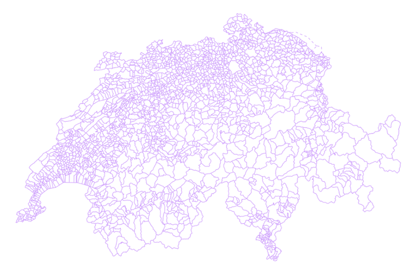
Municipal boundaries - journey through time
The layer municipal boundaries constitute the administrative borders of the municipalities of Switzerland and the principality of Liechtenstein. The municipality is the smallest administrative unit. By default, the current status of municipal boundaries is displayed. With the historical data representation tool - called " journey through time - the evolution of municipal boundaries from 1850 to the present day is interactive. When a year prior to the current status is selected, the status of municipal boundaries on the first of January is displayed. For the current status, mergers of municipalities during the year are included. Two data sources have been used to generate this layer: "Municipal boundaries: time series since 1850s" from the Swiss Federal Statistical Office for the period 1850 - 2015 and swissBOUNDARIES3D from the Swiss Federal Office of Topography for the period 2016 to the present.
Simple
- Alternate title
-
Municipal boundaries
- Date (Revision)
- 2025-12-18
- Date (Publication)
- 2026-01-01
- Identifier
- ch.swisstopo.swissboundaries3d-gemeinde-flaeche.fill
Point of contact
Resource provider
Spatial resolution
Equivalent scale
- Denominator
- 10000
- Topic category
-
- D Boundaries
Extent
Extent
- Description
-
Switzerland
))

Extent
Extent
- Description
-
Liechtenstein
))

- Maintenance and update frequency
- Annually
- Maintenance note
-
Updating is based on information provided by the Cadastral Survey (CS) and the Federal Statistical Office. swissBOUNDARIES3D is always fully updated at the beginning of the year. When municipality fusions take place during the year, swisstopo will publish a special update as soon as possible. In this case, the special edition of swissBOUNDARIES3D includes only selective adjustments related to the fusion.
- GEMET - INSPIRE themes, version 1.0
-
-
Administrative units
-
- geocat.ch
-
-
INSPIRE
-
opendata.swiss
-
- GEMET
-
-
municipality
-
- geocat.ch
-
-
FSDI Federal Spatial Data Infrastructure
-
- GEMET
-
-
administrative boundary
-
Resource constraints
- Other constraints
-
NonCommercialAllowed-CommercialAllowed-ReferenceRequired
Associated resource
- Association Type
- Reference to a master resource of which this one is a part
- Metadata Reference
Associated resource
- Association Type
- Reference to a master resource of which this one is a part
- Metadata Reference
Associated resource
- Title
-
Administrative boundaries (national survey)
- Association Type
- Reference to a master resource of which this one is a part
- Language
- Deutsch
- Character encoding
- UTF8
- Language
- Français
- Character encoding
- UTF8
- Language
- English
- Character encoding
- UTF8
- Basic Geodata
- true
- Basic Geodata ID
-
39.3
- Basic Geodata Legal Level
- Federal
- Included with dataset
- 0
- Title
-
swissBOUNDARIES3D Grenzen Schweizweit in 3D
- Date (Publication)
- 2026-01-01
- Distribution format
-
-
OGC Geopackage (GPKG)
-
ESRI File Geodatabase FileGDB (GDB)
-
ESRI Shapefile (SHP)
-
INTERLIS 2 (XTF)
-
Digital transfer options
- OnLine resource
-
Vorschau map.geo.admin.ch
Preview map.geo.admin.ch
Digital transfer options
- OnLine resource
-
ch.swisstopo.swissboundaries3d-gemeinde-flaeche.fill
WMS-FSDI service, layer "Municipal boundaries"
Digital transfer options
- OnLine resource
-
ch.swisstopo.swissboundaries3d-gemeinde-flaeche.fill
WMTS-FSDI service, layer "Municipal boundaries"
Digital transfer options
- OnLine resource
-
swissBOUNDARIES3D
Digital transfer options
- OnLine resource
-
Downloadseite
Digital transfer options
- OnLine resource
-
Gemeindegrenzen: Zeitreihe seit 1850
Digital transfer options
- OnLine resource
-
Linked Data
Digital transfer options
- OnLine resource
-
RESTful API von geo.admin.ch
RESTful API from geo.admin.ch
Digital transfer options
- OnLine resource
-
Linked Data Dienst (via SPARQL)
- Geometric object type
- Curve
- Geometric object type
- Surface
- Reference system identifier
- EPSG:2056
Metadata
- Metadata identifier
- 9961dc6c-20a9-4b16-8a24-b20c3d8ddb83
- Language
- Deutsch
- Character encoding
- UTF8
- Language
- Français
- Character encoding
- UTF8
- Language
- Italiano
- Character encoding
- UTF8
- Language
- English
- Character encoding
- UTF8
- Language
- Rumantsch
- Character encoding
- UTF8
Point of contact
Type of resource
- Resource scope
- Dataset
- Metadata linkage
-
https://www.geocat.ch/geonetwork/srv/api/records/9961dc6c-20a9-4b16-8a24-b20c3d8ddb83
- Date info (Creation)
- 2011-10-24T08:56:32Z
- Date info (Revision)
- 2026-04-13T09:16:21.832211Z
Metadata standard
- Title
-
eCH-0271