geocat.ch
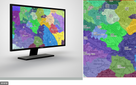
Official index of cities and towns including postal codes and perimeter
In Article 24 of the regulations governing geographic names (GeoNV), the Federal Office of Topography (swisstopo) is commissioned to establish, administer and publish the new official index of cities and towns including postal codes and perimeter. The data are stored centrally at swisstopo.The data set covers all of Switzerland and is available free of charge (Datensatz wird monatlich nachgeführt).
I dati sono stati pubblicati in un nuovo modello di dati dal 1° gennaio 2024.
Simple
- Alternate title
-
Official index of cities and towns
- Date (Revision)
- 2026-06-01T00:00:00
- Date (Creation)
- 2010-01-01T00:00:00
- Identifier
- ch.swisstopo-vd.ortschaftenverzeichnis_plz
Point of contact
Owner
- Spatial representation type
- Vector
- Topic category
-
- B Location
Extent
Extent
- Description
-
Switzerland
))

- Maintenance and update frequency
- Monthly
- Maintenance note
-
In collaboration with the Swiss Post Office, the data were collected by the cantonal surveying authorities who are responsible for their maintenance and update.
- Duration of Conservation
- 275
- Appraisal of Archival Value
- A
- Reason for Archiving Value
- Evidence of business practice
- geocat.ch
-
-
e-geo.ch
-
post code
-
place
-
official geodata
-
opendata.swiss
-
Conservation and archiving planning AAP - Confederation
-
cadastral surveying
-
- GEMET - INSPIRE themes, version 1.0
-
-
Administrative units
-
Addresses
-
- geocat.ch
-
-
FSDI Federal Spatial Data Infrastructure
-
Associated resource
- Title
-
Répertoire officiel des localités avec le code postal et le périmètre
- Association Type
- Reference to a master resource of which this one is a part
- Language
- Français
- Character encoding
- UTF8
- Language
- Deutsch
- Character encoding
- UTF8
- Language
- Italiano
- Character encoding
- UTF8
- Basic Geodata
- true
- Basic Geodata ID
-
181.1
- Basic Geodata Legal Level
- Federal
- Basic Geodata Type
- basicGeodata
- Included with dataset
- 0
- Title
-
Geodata Model for Official Index of Localities
- Alternate title
-
OfficialIndexOfLocalities
- Date (Publication)
- 2024-01-01
- Distribution format
-
-
ESRI Shapefile (SHP)
-
ESRI Personal Geodatabase (Personal-GDB)
-
INTERLIS 2 (XTF)
-
TEXT, semicolon separated (CSV)
-
Digital transfer options
- OnLine resource
-
Aperçu map.geo.admin.ch
Preview map.geo.admin.ch
Digital transfer options
- OnLine resource
-
ch.swisstopo-vd.ortschaftenverzeichnis_plz
WMS-FSDI service, layer "Official index of cities and towns"
Digital transfer options
Digital transfer options
Digital transfer options
- OnLine resource
-
RESTful API de geo.admin.ch
RESTful API from geo.admin.ch
Metadata
- Metadata identifier
- 972cd117-f1ed-4818-be14-233d89ab9fdf
- Language
- Français
- Character encoding
- UTF8
- Language
- Deutsch
- Character encoding
- UTF8
- Language
- Italiano
- Character encoding
- UTF8
- Language
- English
- Character encoding
- UTF8
- Language
- Rumantsch
- Character encoding
- UTF8
Point of contact
Type of resource
- Resource scope
- Dataset
- Metadata linkage
-
https://www.geocat.ch/geonetwork/srv/api/records/972cd117-f1ed-4818-be14-233d89ab9fdf
- Date info (Creation)
- 2010-09-29T08:50:31Z
- Date info (Revision)
- 2026-05-28T11:37:51.6887Z
Metadata standard
- Title
-
eCH-0271