geocat.ch
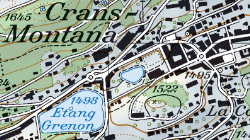
Swiss Map Raster 1:25'000 (VS)
La carte nationale au 1:25’000 est la carte topographique suisse avec une représentation très détaillée des voies de communications, des surfaces bâties, de l’hydrographie, du terrain et de la végétation. La SMR25 est la carte nationale digitalisée, livrable sous forme de données raster géoréférencées (format TIF). Les cartes-pixel sont à dispositions en couleurs combinées (KOMB; 508 dpi) ainsi que par couches de couleurs séparées (données binaires 508 dpi). De plus, la version combinaisons de couleurs dans une résolution de 254 dpi contient le relief ombré (KREL).
Simple
- Alternate title
-
Swiss Map Raster 25
- Date (Creation)
- 1952-06-30
- Date (Revision)
- 2024-11-01
- Identifier
- 150/151/317
- Purpose
-
fond visuel
- Status
- On going
Custodian
- Spatial representation type
- Grid
Spatial resolution
Equivalent scale
- Denominator
- 25000
- Topic category
-
- A Imagery base maps earth cover
Extent
Extent
- Description
-
Canton of Valais (VS)
))

- Maintenance and update frequency
- userDefined
- Maintenance note
-
La mise à jour s’effectue par secteur suivant un cycle de 6 ans.
Resource format
- Title
-
ESRI Enterprise Geodatabase
- Date
- GEMET
-
-
cartography
-
- geocat.ch
-
-
topography
-
terrain representation
-
national map
-
official geodata
-
- GEMET
-
-
map chart
-
Resource constraints
- Use limitation
-
sous licence
Resource constraints
- Access constraints
- Other restrictions
- Other constraints
-
Géodonnées accessibles au public (niveau A selon l'OGéo)
- Other constraints
-
Les conditions générales d'utilisation des géodonnées du Canton du Valais font foi ( https://www.vs.ch/fr/web/guest/information-legale).
- Language
- Français
- Character encoding
- UTF8
- Language
- Deutsch
- Character encoding
- UTF8
- Environment description
-
S:\Géodonnées VS\A1 Cartes de référence\ Swiss Map Raster 25 avec Relief.lyr S:\Géodonnées VS\A1 Cartes de référence\ Swiss Map Raster 25.lyr
- Supplemental Information
-
Etat des mises à jour S:\Géodonnées VS\A1 Cartes de référence\Swiss Map Raster 25 Index.lyr
- Subtopic Category
- A1 Base Maps, Landscape Models
- Basic Geodata
- true
- Basic Geodata ID
-
42.1
- Basic Geodata Legal Level
- Federal
- Basic Geodata Type
- Reference Geodata
- Distribution format
-
-
GeoTIFF (GEOTIFF)
-
Cloud Optimized GeoTIFF (TIFF / TIF)
-
Distributor
- Reference system identifier
- EPSG:2056/CH1903+_MN95
Metadata
- Metadata identifier
- 9721c97d-ba3d-4fb2-8c8d-fac8de33c644
- Language
- Français
- Character encoding
- UTF8
- Language
- Deutsch
- Character encoding
- UTF8
- Language
- Italiano
- Character encoding
- UTF8
- Language
- English
- Character encoding
- UTF8
- Language
- Rumantsch
- Character encoding
- UTF8
Distributor
Type of resource
- Resource scope
- Dataset
- Metadata linkage
-
https://www.geocat.ch/geonetwork/srv/api/records/9721c97d-ba3d-4fb2-8c8d-fac8de33c644
- Date info (Creation)
- 2014-12-16T17:22:56Z
- Date info (Revision)
- 2026-05-29T09:20:18.848074Z
Metadata standard
- Title
-
eCH-0271