 geocat.ch
Les chaînons manquants transfrontaliers dans les infrastructures cyclables du Rhin Supérieur
Grenzüberschreitende Netzlücken der Fahrradinfrastruktur am Oberrhein
Cross-border network gaps of the cycling infrastructure on the Upper Rhine
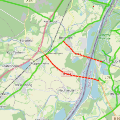
Carte interactive qui représente les différents chaînons manquants cyclables du Rhin Supérieur.
Interaktive Karte, die die verschiedenen Lücken in der Fahrradinfrastruktur am Oberrhein darstellt.
Interactive map showing the various missing cycling links in the Upper Rhine.
Simple
-
Datum (Erstellung)Date (Creation)Date (Création)
- 2022-10-01
-
Datum (Publikation)Date (Publication)Date (Publication)
- 2023-04-05T08:33:49
-
PräsentationsformPresentation formForme de la présentation
-
Digitale KarteDigital mapCarte numérique
-
BearbeitungsstatusStatusÉtat
-
AbgeschlossenCompletedTerminé
Ausdehnung
Extent
Étendue
Ausdehnung
Extent
Étendue
N
S
E
W
))
-
WartungsintervallMaintenance and update frequencyFréquence de mise à jour
-
UnbekanntUnknownInconnue
- GEMET - Concepts, version 2.4
-
-
piste cyclable
Radweg
cycle path
-
transport
Transport
transportation
-
- Keywords
-
-
Mviewer
-
-
SpracheLanguageLangue
- Français
-
SpracheLanguageLangue
- Deutsch
-
AbgabeformatDistribution formatFormat de distribution
-
-
OGC:OWS-C
-
Optionen für die digitale Übertragung
Digital transfer options
Options de transfert numérique
Optionen für die digitale Übertragung
Digital transfer options
Options de transfert numérique
-
Name des ReferenzsystemsReference system identifierNom du système de référence
- EPSG:3857
Metadata
-
Identifikator des MetadatensatzesMetadata identifierIdentifiant des métadonnées
- 9576ee08-78b4-4f8e-a54b-d9dd9a93ce5f
-
SpracheLanguageLangue
- Français
-
ZeichenkodierungCharacter encodingEncodage de caractères
-
Utf8UTF8Utf8
-
SpracheLanguageLangue
- Deutsch
-
ZeichenkodierungCharacter encodingEncodage de caractères
-
Utf8UTF8Utf8
-
SpracheLanguageLangue
- English
-
ZeichenkodierungCharacter encodingEncodage de caractères
-
Utf8UTF8Utf8
Anwendungsbereich der Metadaten
Type of resource
Type de ressource
-
Domäne der RessourcenanwendungResource scopeDomaine d'application de la ressource
-
interactiveMapinteractiveMapinteractiveMap
-
NameNameNom
-
1.0
-
Datumsangaben (Aktualisierung)Date info (Revision)Informations de date (Révision)
- 2023-06-01T15:16:27.987143Z
Metadatenstandard
Metadata standard
Norme des métadonnées
-
TitelTitleTitre
-
ISO 19115-3:2018
-
AusgabeEditionÉdition
-
1.0
)))