geocat.ch
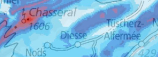
Windatlas Schweiz: Häufigkeit meteorologischer Vereisung in 100 m Höhe über Grund
Atlas des vents de la Suisse: Fréquence du givrage météorologique à 100 m du sol
Atlante eolico svizzero: Frequenza con cui si riuniscono le condizioni meteorologiche favorevoli alla formazione del ghiaccio
a un’altezza di 100 m sopra il livello del terreno
Wind Atlas of Switzerland: Frequency of meteorological icing at 100 metres above the ground
Atlas dal vent da la Svizra: frequenza d'englatschaments meteorologics sin 100 m sur il terren
In der Schweiz liegen die Potentialgebiete für Windenergie unter anderem auf den Jurahöhen, wie auch in den Alpen und Voralpen. Während der Wintermonate liegt dort die Lufttemperatur regelmässig und für längere Zeit unter 0° Celsius. Damit verbunden sind Vereisungseffekte an Messinstrumenten und Rotorblättern.Die Vereisung beeinflusst die Planung und den Betrieb einer Windenergieanlage (WEA) auf unterschiedliche Weise: Eisansatz an den Rotorblättern führt zu einer gestörten Aerodynamik der Flügel und verursacht Produktionsverluste. Die mit der Vereisung verbundenen Zusatzlasten und Unwuchten belasten die Strukturelemente der WEA. Aus Sicherheitsgründen (Eiswurf) und auf Grund der zusätzlichen Materialbelastung werden die WEA bei Vereisung abgeschaltet. Weiter kann Eisansatz an den Windmessgeräten einer WEA zu einem fehlerhaften Betrieb führen. Die Berechnungen der Vereisungshäufigkeit basieren auf flächendeckenden Daten zu Wolkenwasser, Temperatur und Wind aus der Analyse des Wettervorhersagemodells COSMO-2 der MeteoSchweiz. Das Vereisungsmodell berechnet die Eislast an einer zylindrischen, frei rotierenden Struktur. Die Vereisungshäufigkeit liegt auf einem 2.2-km-Raster vor und wurde anhand von Messungen von IMIS-Stationen in den Alpen und Messungen im Jura verifiziert. Die Karte zeigt die Häufigkeit meteorologischer Vereisung auf 100 m über Grund für den Zeitraum August 2007 bis Juli 2009. Im 10-Jahres-Mittel liegt die mittlere Vereisung etwa 5% tiefer. Die Häufigkeitsangaben sind modellierte Werte. Sie geben Hinweise, wo in der Schweiz Vereisungen auftreten können. Die Häufigkeitsangaben können nicht als punktgenaue, exakte Werte interpretiert werden. In kleinräumigem Gelände, wie es häufig in den Zentralalpen anzutreffen ist, gibt es Abweichungen. Bei stark exponierten Lagen liegt der Vereisungswert höher, bei abgeschatteter Lage liegt der Vereisungswert tiefer als in der Karte dargestellt. Auf der Karte ist die meteorologische Vereisung dargestellt, die Perioden von instrumenteller Vereisung dauern im Durchschnitt länger. Bei Interesse an einer Standortentwicklung ist eine Messung vor Ort unumgänglich.
En Suisse, les zones propices à l’exploitation de l’énergie éolienne se trouvent notamment sur les hauteurs du Jura, dans les Apes et les Préalpes, soit des régions où la température demeure régulièrement et longtemps au-dessous de 0 °C en hiver. Les effets du givre sur les instruments de mesure et les pales des éoliennes entrent donc en considération.Le givrage influence la planification et l’exploitation d’une éolienne de diverses façons: son dépôt sur les pales peut nuire à l’aérodynamisme de celles-ci et entraîner des pertes de production. Les charges supplémentaires et les déséquilibres qui en résultent entraînent une fatigue de la structure de l’éolienne. Pour des raisons de sécurité (glaçons) et en raison de la fatigue du matériel, les éoliennes sont désactivées en cas de givrage. La présence de givre sur les instruments de mesure d’une éolienne peut par ailleurs perturber le fonctionnement de celle-ci Les calculs de la fréquence de givrage se fondent sur des données exhaustives concernant l’eau des nuages, la température et le vent issues de l’analyse du modèle de prévisions météorologiques COSMO-2 de MétéoSuisse. Le modèle de givrage calcule le dépôt de givre sur une structure cylindrique en rotation libre. La fréquence de givrage est présentée sur une grille de 2,2 km. Elle a été vérifiée sur la base de mesures de stations IMIS situées dans les Alpes et de mesures effectuées dans le Jura. La carte affiche la fréquence du givrage météorologique à 100 m du sol pour la période d’août 2007 à juillet 2009. Sur une période de 10 ans, le givrage moyen baisse d’environ 5%. Les indications de fréquence sont des valeurs modélisées. Elles donnent des indications sur les endroits où le givrage peut se manifester en Suisse. Il ne s’agit pas de valeurs exactes très précises. Les reliefs de petite superficie, comme ceux que l’on trouve fréquemment dans les Alpes centrales, présentent des écarts. La valeur de givrage est plus élevée que celle figurant sur la carte dans les endroits fortement exposés et moins élevée dans les zones ombragées. La carte présente le givrage météorologique, les périodes de givrage instrumental durent en moyenne plus longtemps. En cas d'intérêt pour le développement d’un site, il est indispensable d'effectuer des mesures sur place.
In Svizzera le zone con un potenziale per l'energia eolica si trovano, tra l'altro, sulla catena del Giura, nelle Alpi e nelle Prealpi. Su queste alture, durante i mesi invernali la temperatura dell'aria permane per molto tempo costantemente al di sotto degli 0° Celsius. Ne conseguono effetti legati alla formazione del ghiaccio sugli anemometri e sulle pale dei rotori. La formazione del ghiaccio influisce in vari modi sulla pianificazione e sull’esercizio di un impianto a energia eolica: il suo accumulo sulle pale dei rotori provoca un malfunzionamento delle stesse a livello aerodinamico, causando perdite sul piano della produzione. Il carico aggiuntivo e lo squilibrio derivanti dalla formazione del ghiaccio hanno un impatto sugli elementi strutturali dell'impianto: in caso di formazione di ghiaccio, quest’ultimo viene spento per motivi di sicurezza (rischio di caduta di pezzi di ghiaccio) e a causa del carico aggiuntivo a cui sono soggette le sue componenti. Oltre a ciò, l'accumulo di ghiaccio sugli anemometri di un impianto eolico può provocare un malfunzionamento. I calcoli relativi alla frequenza con cui si riuniscono le condizioni meteorologiche favorevoli alla formazione del ghiaccio si basano su rilevamenti capillari circa il contenuto d'acqua delle nubi, la temperatura e il vento; tali dati provengono dall'analisi del modello di previsione meteorologica COSMO-2 di MeteoSvizzera. Il modello relativo alla formazione del ghiaccio calcola il carico esercitato da quest'ultimo su una struttura cilindrica a rotazione libera. La frequenza con cui si riuniscono le condizioni meteorologiche favorevoli alla sua formazione è rappresentata su una griglia con risoluzione 2,2 km ed è stata verificata sulla base delle misurazioni effettuate presso le stazioni meteorologiche IMIS nelle Alpi e dei dati raccolti nel Giura. La carta mostra la frequenza con cui sono verificate le condizioni meteorologiche favorevoli alla formazione del ghiaccio a un'altezza di 100 m dal suolo, per il periodo compreso tra agosto 2007 e luglio 2009. Nell'arco di 10 anni, la formazione del ghiaccio è mediamente inferiore del 5% circa. Le indicazioni relative alla frequenza sono valori modellizzati, che mostrano in quali località svizzere è possibile che si verifichi la formazione di ghiaccio. Le indicazioni sulla frequenza non vanno interpretate come valori esatti: infatti, in zone di piccole dimensioni, come è spesso il caso nelle Alpi centrali, sono possibili variazioni. Località molto esposte agli agenti atmosferici presentano un valore di formazione del ghiaccio più elevato, mentre in quelle riparate esso sarà inferiore rispetto a quanto appare sulla carta. Su quest'ultima viene mostrata la durata in cui si riuniscono le condizioni meteorologiche favorevoli alla formazione del ghiaccio, mentre i periodi in cui il ghiaccio è effettivamente presente sulle componenti strumentali sono, in media, più lunghi. Qualora vi sia l'interesse a sviluppare una determinata ubicazione non si può prescindere da una misurazione in loco.
In Switzerland, the mountain regions (Jura, Alps and Alpine foothills) are the most suitable regions for exploiting wind energy potential. But here, the air temperature during the winter months is frequently below 0° C for lengthy periods, and this can cause measuring instruments and rotor blades to ice up. Icing influences the planning and operation of a wind power plant in a variety of ways: ice formation on the rotor blades interferes with their aerodynamics and results in production losses. The additional weight and imbalance associated with ice formation also burden the structural elements of a wind turbine. For safety reasons (ice fall-off), and in view of the additional burden placed on their components, wind turbines have to be turned off when they ice up. Ice formation on a wind turbine’s measuring instruments can also give rise to faulty operation. Calculations of icing frequency are based on comprehensive data relating to cloud water, temperature and wind obtained from analyses of the MeteoSwiss COSMO-2 weather forecasting model. The icing model calculates the ice load on a cylindrical, freely rotating structure. The icing frequency is depicted on a 2.2-kilometre raster and has been verified on the basis of measurements carried out at IMIS stations in the Alps and readings recorded in the Jura range. The map depicts the frequency of meteorological icing at a height of 100 metres above the ground for the period from August 2007 to July 2009. The 10-year average is around 5 percent lower. The frequency data are based on calculations made with the aid of models, and they indicate where icing can occur in Switzerland. However, the data cannot be regarded as absolutely precise for a given location, because deviations can occur in confined spaces such as those frequently encountered in the central Alps. The frequency of icing is higher in exposed areas and lower in protected areas than the levels shown on the map. The map depicts meteorological icing, while the periods of measured icing tend to be longer on average. To assess the icing conditions at a specific location, measurement on site is thus essential.
En Svizra sa chattan ils territoris potenzials per energia da vent tranter auter sin las collinas dal Giura, sco er en las Alps ed en las Prealps. Durant ils mais d'enviern ha l'aria là regularmain e per in temp pli lung ina temperatura da main che 0° celsius. Colliads cun quai èn effects d'englatschament vi d'instruments da mesiraziun e vi da las palas dals roturs. L'englatschament influenzescha la planisaziun ed il manaschi d'in implant d'energia da vent (IEV) a differenta moda: glatsch sin las palas dal rotur disturba l'erodinamica da las palas e chaschuna perditas da producziun. Il pais supplementar ed il dischequiliber da las palas ch'èn colliads cun l'englatschament engrevgeschan ils elements structurals dals IEV. Per motivs da segirezza (glatsch che vegn schlavazzà davent) e sin basa da la chargia supplementara per il material vegnan ils IEV serrads giu en cas d'in englatschament. Plinavant po l'englatschament dals instruments d'in IEV che mesiran il vent disturbar ses funcziunament. Las calculaziuns quant savens ch'i dat englatschaments sa basa sin datas naziunalas davart l'aua dals nivels, davart la temperatura e davart il vent che derivan da l'analisa dal model da la previsiun da l'aura COSMO-2 da MeteoSvizra. Il model d'englatschament calculescha la chargia da glatsch vi d'ina structura cilindrica che rotescha libramain. La frequenza d'englatschaments vegn mussada sin in raster da 2,2 km ed è vegnida verifitgada a maun da mesiraziuns da staziuns IMIS en las Alps e da mesiraziuns sin il Giura. La charta mussa quant savens ch'i ha dà englatschaments meteorologics sin 100 m sur il terren per la perioda da l'avust 2007 fin il fanadur 2009. En la media da 10 onns è la media dals englatschaments var 5 % pli bassa. Las indicaziuns da la frequenza èn valurs modelladas. Ellas infurmeschan, nua ch'i po dar englatschaments en Svizra. Las indicaziuns da la frequenza na pon betg vegnir interpretadas sco valurs exactas per in tschert punct. Sche la topografia è structurada fermamain, sco che quai è savens il cas en las Alps centralas, datti divergenzas. En lieus exponids fermamain datti pli savens englatschaments, en lieus protegids datti main englatschaments che mussà sin la charta. Sin la charta vegnan mussadas las cundiziuns meteorologicas, durant las qualas i po dar englatschaments, las periodas d'englatschament dals instruments duran en media pli ditg. Sch'in interess per il svilup d'in tschert lieu è avant maun, ston vegnir fatgas mesiraziuns al lieu.
Simple
-
Autre titreAltri nomi o acronimiAlternate titleAlternate titleAlternativtitel
-
Vereisungshäufigkeit
Fréquence de givrage
Frequenza formazione ghiaccio
Icing Frequency
Frequenza d'englatschament
-
Date (Création)Data (Creazione)Date (Creation)Date (Creation)Datum (Erstellung)
- 2010-05-31T00:00:00
-
Date (Révision)Data (Revisione)Date (Revision)Date (Revision)Datum (Aktualisierung)
- 2016-05-31
-
IdentifiantIdentificatoreIdentifierIdentifierKennung
- ch.bfe.meteorologische-vereisung
Point de contact
Punto di contatto
Point of contact
Point of contact
Ansprechpartner
Résolution spatiale
Risoluzione spaziale
Spatial resolution
Spatial resolution
Räumliche Auflösung
Fraction représentative
Frazione rappresentativa
Equivalent scale
Equivalent scale
Vergleichsmassstab
-
DénominateurDenominatoreDenominatorDenominatorMassstabszahl
- 5000
Résolution spatiale
Risoluzione spaziale
Spatial resolution
Spatial resolution
Räumliche Auflösung
Fraction représentative
Frazione rappresentativa
Equivalent scale
Equivalent scale
Vergleichsmassstab
-
DénominateurDenominatoreDenominatorDenominatorMassstabszahl
- 1000000
-
Catégorie de thèmeCategoria ISOTopic categoryTopic categoryThematik
-
-
Q Utilitaires de communicationQ Comunicazioni di pubblica utilitàQ Utilities communicationQ Utilities communicationQ Ver- und Entsorgung, Kommunikation
-
Étendue
Estensione
Extent
Extent
Ausdehnung
Étendue
Estensione
Extent
Extent
Ausdehnung
-
DescriptionDescrizioneDescriptionDescriptionBeschreibung
-
Switzerland
Schweiz
Suisse
Svizzera
Svizra
))

-
Fréquence de mise à jourFrequenza di aggiornamentoMaintenance and update frequencyMaintenance and update frequencyWartungsintervall
-
InconnueSconosciutoUnknownUnknownUnbekannt
- geocat.ch
-
-
opendata.swiss
opendata.swiss
opendata.swiss
opendata.swiss
-
- GEMET
-
-
météorologie
meteorologia
meteorology
-
énergie
energia
energy
-
énergie éolienne
energia eolica
wind power
-
centrale à énergie éolienne
generatore eolico
wind power station
-
- geocat.ch
-
-
BGDI Bundesgeodaten-Infrastruktur
IFDG l’Infrastructure Fédérale de données géographiques
IFDG Infrastruttura federale dei dati geografici
FSDI Federal Spatial Data Infrastructure
-
Contraintes sur la ressource
Vincoli sulle risorse
Resource constraints
Resource constraints
Ressourcenbeschränkungen
-
Contraintes d'utilisationVincoli d'usoUse constraintsUse constraintsNutzungseinschränkungen
-
Autres restrictionsAltre restrizioniOther restrictionsOther restrictionsAndere Beschränkungen
-
Autres contraintesAltri vincoliOther constraintsOther constraintsAndere Einschränkungen
- Opendata BY: Freie Nutzung. Quellenangabe ist Pflicht.Opendata BY: Utilisation libre. Obligation d’indiquer la source.Opendata BY: Libero utilizzo. Indicazione della fonte obbligatoria.Opendata BY: Open use. Must provide the source.https://www.admin.ch/gov/de/start/rechtliches.html
-
LangueLinguaLanguageLanguageSprache
- Deutsch
-
Encodage de caractèresCodifica dei caratteriCharacter encodingCharacter encodingZeichenkodierung
-
Utf8UTF8UTF8UTF8Utf8
-
Catégorie de sous-thèmeCategoria di sottotemaSubtopic CategorySubtopic CategoryThematische Unterkategorien
-
Q1 ÉnergieQ1 EnergiaQ1 EnergyQ1 EnergyQ1 Energie
-
Géodonnées de baseGeodati di baseBasic GeodataBasic GeodataGeobasisdaten
- false
-
Niveau des géodonnées de baseLivello legale dei geodati di baseBasic Geodata Legal LevelBasic Geodata Legal LevelGeobasisdatenebene
-
FédéralFederaleFederalFederalNational
-
Format de distributionFormato (codifica)Distribution formatDistribution formatAbgabeformat
-
-
GeoTIFF (GEOTIFF)
-
Options de transfert numérique
Opzioni di trasferimento digitale
Digital transfer options
Digital transfer options
Optionen für die digitale Übertragung
Options de transfert numérique
Opzioni di trasferimento digitale
Digital transfer options
Digital transfer options
Optionen für die digitale Übertragung
-
Ressource en ligneRisorsa onlineOnLine resourceOnLine resourceOnline
-
ch.bfe.meteorologische-vereisung
WMS-BGDI Dienst, Layer "Vereisungshäufigkeit"Service WMS-IFDG, couche "Fréquence de givrage"Servizio WMS-IFDG, strato "Frequenza formazione ghiaccio"WMS-FSDI service, layer "Icing Frequency"WMS-BGDI Dienst, Layer "Vereisungshäufigkeit"
Options de transfert numérique
Opzioni di trasferimento digitale
Digital transfer options
Digital transfer options
Optionen für die digitale Übertragung
-
Ressource en ligneRisorsa onlineOnLine resourceOnLine resourceOnline
-
ch.bfe.meteorologische-vereisung
WMTS-BGDI Dienst, Layer "Vereisungshäufigkeit"Service WMTS-IFDG, couche , Layer "Fréquence de givrage"Servizio WMTS-IFDG, strato "Frequenza formazione ghiaccio"WMTS-FSDI service, layer "Icing Frequency"WMTS-BGDI Dienst, Layer "Vereisungshäufigkeit"
Options de transfert numérique
Opzioni di trasferimento digitale
Digital transfer options
Digital transfer options
Optionen für die digitale Übertragung
-
Ressource en ligneRisorsa onlineOnLine resourceOnLine resourceOnline
-
GeoTIFF
GeoTIFF
Options de transfert numérique
Opzioni di trasferimento digitale
Digital transfer options
Digital transfer options
Optionen für die digitale Übertragung
Options de transfert numérique
Opzioni di trasferimento digitale
Digital transfer options
Digital transfer options
Optionen für die digitale Übertragung
-
Ressource en ligneRisorsa onlineOnLine resourceOnLine resourceOnline
-
swisstopo REST API
swisstopo REST API
-
Type d’objet géométriqueTipo di oggetto geometricoGeometric object typeGeometric object typeTyp des geometrischen Objekts
-
PolygoneSuperficieSurfaceSurfacesurface
-
Nom du système de référenceNome del sistema di riferimentoReference system identifierReference system identifierName des Referenzsystems
- EPSG:2056
Metadata
-
Identifiant des métadonnéesIdentificativo della schedaMetadata identifierMetadata identifierIdentifikator des Metadatensatzes
- 94cedad7-6d19-46b2-9ecf-0d1d1a58bea8
-
LangueLinguaLanguageLanguageSprache
- Deutsch
-
Encodage de caractèresCodifica dei caratteriCharacter encodingCharacter encodingZeichenkodierung
-
Utf8UTF8UTF8UTF8Utf8
-
LangueLinguaLanguageLanguageSprache
- Français
-
Encodage de caractèresCodifica dei caratteriCharacter encodingCharacter encodingZeichenkodierung
-
Utf8UTF8UTF8UTF8Utf8
-
LangueLinguaLanguageLanguageSprache
- Italiano
-
Encodage de caractèresCodifica dei caratteriCharacter encodingCharacter encodingZeichenkodierung
-
Utf8UTF8UTF8UTF8Utf8
-
LangueLinguaLanguageLanguageSprache
- English
-
Encodage de caractèresCodifica dei caratteriCharacter encodingCharacter encodingZeichenkodierung
-
Utf8UTF8UTF8UTF8Utf8
-
LangueLinguaLanguageLanguageSprache
- Rumantsch
-
Encodage de caractèresCodifica dei caratteriCharacter encodingCharacter encodingZeichenkodierung
-
Utf8UTF8UTF8UTF8Utf8
Point de contact
Punto di contatto
Point of contact
Point of contact
Ansprechpartner
Type de ressource
Tipo di risorsa
Type of resource
Type of resource
Anwendungsbereich der Metadaten
-
Domaine d'application de la ressourceAmbito di applicazione della risorsaResource scopeResource scopeDomäne der Ressourcenanwendung
-
Jeu de donnéesSet di datiDatasetDatasetDatenbestand
-
Lien vers la métadonnéeCollegamento ai metadatiMetadata linkageMetadata linkageLink zu den Metadaten
-
Informations de date (Création)Informazioni sulla data (Creazione)Date info (Creation)Date info (Creation)Datumsangaben (Erstellung)
- 2016-07-21T11:36:44Z
-
Informations de date (Révision)Informazioni sulla data (Revisione)Date info (Revision)Date info (Revision)Datumsangaben (Aktualisierung)
- 2026-06-15T08:53:43.306773Z
Norme des métadonnées
Standard dei metadati
Metadata standard
Metadata standard
Metadatenstandard
-
TitreTitoloTitleTitleTitel
-
eCH-0271