geocat.ch
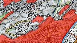
Secteurs archéologiques
Les secteurs archéologiques désignent des surfaces pour lesquelles la présomption de présence de vestiges archéologiques est particulièrement élevée et constituent le principal document utilisé lors de l’émission de préavis par l’archéologie cantonale. Ils permettent ainsi d’intégrer le suivi archéologique dans les processus de construction, d’anticiper la nécessité d’investigations archéologiques et d’éviter des découvertes inattendues risquant de bloquer un chantier déjà en cours.
Simple
- Alternate title
-
Secteurs archéologiques
- Date (Creation)
- 2012-12-12
- Date (Revision)
- 2026-03-25
- Identifier
- 21
- Purpose
-
Préaviser les dossiers de construction en secteur archéologique. Protection des secteurs à potentiel archéologique, y compris hors zone à bâtir
- Status
- On going
Custodian
- Spatial representation type
- Vector
Spatial resolution
Equivalent scale
- Denominator
- 10000
- Topic category
-
- E Planning cadastre
- O Structure
Extent
Extent
- Description
-
Canton of Valais (VS)
))

- Maintenance and update frequency
- As needed
Resource format
- Title
-
ESRI Enterprise Geodatabase
- Date
- GEMET - INSPIRE themes, version 1.0
-
-
Protected sites
-
- GEMET
-
-
archaeology
-
- geocat.ch
-
-
opendata.swiss
-
opendata.swiss
-
Resource constraints
- Use limitation
-
aucunes
Resource constraints
- Access constraints
- Other restrictions
- Other constraints
- Publicly accessible basic geodata : level A (GeoIV, Art. 21).
- Other constraints
-
Les conditions générales d'utilisation des géodonnées du Canton du Valais font foi ( https://www.vs.ch/fr/web/guest/information-legale).
- Language
- Français
- Character encoding
- UTF8
- Environment description
-
S:\Géodonnées VS\E1 Développement territorial\Secteurs archéologiques.lyr
- Subtopic Category
- E1 Spatial Planning, Spatial Development
- Included with dataset
- 0
- Title
-
Catalogue d'objets – Secteurs archéologiques
- Date (Creation)
- 2023-07-04
- Distribution format
-
-
ESRI Shapefile (SHP)
-
OGC Web Map Service (WMS)
-
ArcGIS REST Feature Service
-
Distributor
Digital transfer options
- OnLine resource
-
Géoportail du Canton du Valais
Géoportail du Canton du Valais
Digital transfer options
- OnLine resource
-
OpenData Valais
Site de téléchargement de géodonnées à l'Etat du Valais : multiformat et WebMercator
Digital transfer options
- OnLine resource
-
Landing Page
Landing Page pour opendata
Digital transfer options
- OnLine resource
-
1
secteurs_archeo
Digital transfer options
- OnLine resource
-
Permalink opendata.swiss
Permalink opendata.swiss
Digital transfer options
- OnLine resource
-
Secteurs_archeologiques
Secteurs archéologiques
- Statement
-
Les secteurs archéologiques ont été dessinés sur la base du plan d'ensemble au 1:10000 et du cadastre officiel.
- Hierarchy level
- Dataset
- Description
-
Digitalisation
Equivalent scale
- Denominator
- 10000
- Geometric object type
- Surface
- Geometric object count
- 920
- Reference system identifier
- EPSG:2056/CH1903+_MN95
- Title
-
Modèle de représentation – Secteurs archéologiques
- Date (Publication)
- 2022-01-17
Metadata
- Metadata identifier
- 946b0fd4-b0ad-44b4-b3cb-e543019a93c6
- Language
- Français
- Character encoding
- UTF8
- Language
- Deutsch
- Character encoding
- UTF8
- Language
- Italiano
- Character encoding
- UTF8
- Language
- English
- Character encoding
- UTF8
- Language
- Rumantsch
- Character encoding
- UTF8
Distributor
Type of resource
- Resource scope
- Dataset
- Metadata linkage
-
https://www.geocat.ch/geonetwork/srv/api/records/946b0fd4-b0ad-44b4-b3cb-e543019a93c6
- Date info (Creation)
- 2022-02-07T13:45:03Z
- Date info (Revision)
- 2026-05-06T15:06:43.885323Z
Metadata standard
- Title
-
eCH-0271