geocat.ch
Zones réservées
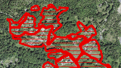
Zones réservées communales et cantonales selon l'art. 19 LcAT. Les zones réservées sont un outil utilisé dans le but de mettre en place le redimensionnement des zones à bâtir. A l'intérieur de ces zones rien ne doit être entrepris qui puisse entraver l'établissement de plans d'affectation de zones. Une zone réservée ne peut être prévue que pour cinq ans au plus; le droit cantonal peut prolonger ce délai.
Simple
- Alternate title
-
Zones réservées
- Date (Creation)
- 2021-08-01
- Date (Revision)
- 2026-01-29
- Identifier
- 533
- Purpose
-
Redimensionnement des zones à bâtir.
- Status
- On going
Custodian
- Spatial representation type
- Vector
Spatial resolution
Equivalent scale
- Denominator
- 2000
- Topic category
-
- E Planning cadastre
Extent
Extent
- Description
-
Canton of Valais (VS)
))

- Maintenance and update frequency
- Continual
Resource format
- Title
-
ESRI Enterprise Geodatabase
- Date
- GEMET
-
-
zoning
-
- GEMET
-
-
land development
-
- GEMET
-
-
allocation
-
- GEMET
-
-
building land
-
- geocat.ch
-
-
local planning
-
official geodata
-
Resource constraints
- Use limitation
-
aucune
Resource constraints
- Access constraints
- Other restrictions
- Other constraints
- Publicly accessible basic geodata : level A (GeoIV, Art. 21).
- Other constraints
-
Les conditions générales d'utilisation des géodonnées du Canton du Valais font foi ( https://www.vs.ch/fr/web/guest/information-legale).
Associated resource
- Association Type
- Reference from one resource to another
- Metadata Reference
- Language
- Français
- Character encoding
- UTF8
- Language
- Deutsch
- Character encoding
- UTF8
- Environment description
-
S:\Géodonnées VS\E1 Développement territorial\Zones réservées.lyr
- Subtopic Category
- E1 Spatial Planning, Spatial Development
- Subtopic Category
- E1 Spatial Planning, Spatial Development
- Basic Geodata
- true
- Basic Geodata ID
-
76>A.1
- Basic Geodata Legal Level
- Communal
- Basic Geodata Type
- basicGeodata oerebRegister
- Distribution format
-
-
ESRI Shapefile (SHP)
-
OGC Web Map Service (WMS)
-
Distributor
Digital transfer options
- OnLine resource
-
7
Zones réservées
- Statement
-
Selon les plans communaux ou cantonaux
- Hierarchy level
- Dataset
- Description
-
Saisie selon plans ou données digitales
- Geometric object type
- Surface
- Geometric object count
- 4321
- Reference system identifier
- EPSG:2056/CH1903+_MN95
Metadata
- Metadata identifier
- 927848bf-4669-4568-b3cb-9cde54caac38
- Language
- Français
- Character encoding
- UTF8
- Language
- Deutsch
- Character encoding
- UTF8
- Language
- Italiano
- Character encoding
- UTF8
- Language
- English
- Character encoding
- UTF8
- Language
- Rumantsch
- Character encoding
- UTF8
Distributor
Type of resource
- Resource scope
- Dataset
- Metadata linkage
-
https://www.geocat.ch/geonetwork/srv/api/records/927848bf-4669-4568-b3cb-9cde54caac38
- Date info (Creation)
- 2021-10-11T13:00:55Z
- Date info (Revision)
- 2026-05-06T15:14:18.262489Z
Metadata standard
- Title
-
eCH-0271