 geocat.ch
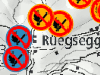
Feuerverbotsschilder-Standorte (Waldbrandmanagement)
Das Geoprodukt zeigt die definierten Standorte für die Feuerverbotsschilder. Die Standorte wurden vom kantonalen Forstdienst in Zusammenarbeit mit Gemeinden oder weiteren Partnern definiert. Wenn in einem oder mehreren Verwaltungskreis(en) von den Regierungsstatthalterämtern ein Feuerverbot erlassen wurde, organisiert die im Geoprodukt bezeichnete Stelle das Auf- und Abhängen.
Simple
- Date (Creation)
- 2019-06-24
- Date (Revision)
- 2026-01-01
- Date (Publication)
- 2026-01-08
- Identifier
- WBMFVSS
- Status
- On going
Owner
Principal investigator
Principal investigator
- Topic category
-
- F Geoscientific information
Extent
Extent
- Description
- Kanton Bern (erweitert) Canton de Berne (étendu)
))
- Maintenance and update frequency
- Irregular
- Keywords
-
-
Waldbrandverhütung
-
Feuerwehr
-
Waldbrand
-
Forstwirtschaft
-
opendata.swiss
-
Resource constraints
- Use limitation
-
Auf sämtlichen Plots und Publikationen ist der Vermerk "Feuerverbotsschilder-Standorte (Waldbrandmanagement) © Amt für Wald und Naturgefahren des Kantons Bern" anzugeben.
Resource constraints
- Use constraints
- Licence End User
- Other constraints
- Die Daten dürfen gemäss Nutzungsbedingungen frei genutzt werden. Les données peuvent être utilisées librement selon les conditions d’utilisation.
Resource constraints
- Other constraints
- Freie Nutzung. Quellenangabe ist Pflicht. Utilisation libre. Obligation d’indiquer la source.
- Language
- Deutsch
- Character encoding
- UTF8
- Language
- Français
- Character encoding
- UTF8
- Language
- Italiano
- Character encoding
- UTF8
- Language
- English
- Character encoding
- UTF8
- Basic Geodata
- false
- Included with dataset
- false
- Distribution format
-
-
SHP
-
GPKG
-
GeoParquet
-
Digital transfer options
- Transfer size
- 731247
- OnLine resource
-
ZIP-Datei mit Shapefile, Metadaten und Begleitdaten
Digital transfer options
- Transfer size
- 641826
- OnLine resource
-
ZIP-Datei mit Geopackage mit Metadaten
Digital transfer options
- Transfer size
- 93949
- OnLine resource
-
Geoparquet-Datei - Zuständigkeit Feuerverbotsschilder
Digital transfer options
- OnLine resource
-
STAC-Collection - WBMFVSS
Digital transfer options
- OnLine resource
-
Link zum Geoportal des Kantons Bern
- Reference system identifier
- CH1903+ / LV95 -- Swiss CH1903+ / LV95/EPSG:2056
Metadata
- Metadata identifier
- 9266a7c0-24e1-48d9-83a6-889eaad8eb20
- Language
- Deutsch
- Character encoding
- UTF8
- Language
- Français
- Character encoding
- UTF8
Point of contact
Type of resource
- Resource scope
- Dataset
- Name
-
Geoprodukt - Géoproduit
- Date info (Creation)
- 2019-06-24T00:00:00Z
- Date info (Revision)
- 2026-01-08T00:00:00Z
Metadata standard
- Title
-
GM03 2+
)))