geocat.ch
Windatlas Schweiz: Jahresmittel der modellierten Windgeschwindigkeit und Windrichtung in 125 m Höhe über Grund
Atlas des vents de la Suisse: moyenne annuelle modélisée de la vitesse et de la direction du vent à 125 m du sol
Atlante eolico svizzero: velocità media annua e direzione media annua del vento a un'altezza di 125m sopra il livello del
terreno secondo modellizzazione
Wind Atlas of Switzerland: Annual average of the modelled wind speed and direction at a height of 125 metres above the ground
Atlas dal vent da la Svizra: media annuala da la sveltezza dal vent modellada e da la direcziun dal vent en 125 m sur il terren
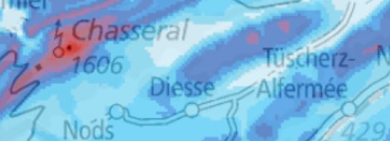
Der Windatlas Schweiz beschreibt die Windverhältnisse auf fünf Höhen über Grund: 50, 75, 100, 125 und 150 m. Die Daten basieren auf einer schweizweiten Modellierung mit einer horizontalen Gitterweite von 100 m. In der Karte ist für jeden Gitterpunkt der modellierte Jahresmittelwert der Windgeschwindigkeit dargestellt. Die Verteilung der Windgeschwindigkeiten in Windgeschwindigkeitsklassen kann mit den Weibullparametern A (Skalenparameter) und k (Formparameter) angenähert werden. Aus den Weibullparametern kann nicht direkt auf den Mittelwert der Windgeschwindigkeit geschlossen werden, da es sich um eine Annäherung an eine Windverteilung handelt und diese nicht für jeden Standort ausreichend wiedergegeben werden kann. Die Windrose zeigt die relative Häufigkeit der modellierten Windrichtungen. Pro Sektor sind die gemittelten Windgeschwindigkeiten und zugehörigen Weibullparameter ersichtlich. Für die Berechnung der Windgeschwindigkeiten und Windrichtungen sind langjährige Messungen in die Modellierung eingeflossen. Da die Messpunkte schweizweit nicht überall in einer angemessenen Dichte vorhanden sind und Ungenauigkeiten bei der Modellierung von Windströmungen im komplexen Gelände auftreten, sind die Resultate mit Unsicherheiten behaftet. Die Grössenordnung der Unsicherheiten liegen im Jurabogen bei bis zu +/- 0.5m/s, im Mittelland bei bis zu +/- 0.7m/s, in den Voralpen bei bis zu +/- 0.5m/s und in den Alpen bei bis zu +/- 1.3m/s. Für die Karten ab 100m Höhe über Grund stehen markant weniger Messungen für die Modellierung zu Verfügung. Dies resultiert in einer höheren Unsicherheit der Ergebnisse. Die Angaben sind als grobe Einschätzung der Windverhältnisse zu verstehen. Bei Interesse an einer Standortentwicklung ist eine Messung vor Ort unumgänglich.
L'Atlas des vents de la Suisse décrit les conditions de vent à cinq hauteurs au-dessus du niveau du sol (50, 75, 100, 125 et 150 m). Les données se fondent sur une modélisation au niveau national avec un maillage horizontal de 100 m.Sur la carte, la moyenne annuelle modélisée de la vitesse du vent est représentée pour chaque maille. La distribution des vitesses du vent en différentes catégories peut être approximée grâce aux paramètres de Weibull A (paramètre d'échelle) et k (paramètre de forme). La valeur moyenne de la vitesse du vent ne peut pas être déduite directement des paramètres de Weibull, car il s'agit d'une approximation d'une distribution du vent et qu'elle ne peut pas être reproduite de manière suffisante pour chaque site. La rose des vents illustre la fréquence relative des directions modélisées du vent. Les vitesses du vent calculées et les paramètres de Weibull qui s'y rapportent sont indiqués par secteur. Pour calculer la vitesse et la direction du vent, on intègre à la modélisation les données de mesure sur plusieurs années. Comme les stations de mesure ne sont pas réparties avec la même densité sur tout le territoire et que des inexactitudes apparaissent lors de la modélisation de la circulation du vent sur des reliefs complexes, les résultats ne sont pas entièrement fiables. L'incertitude varie de ± 0,5 m/s dans l'Arc jurassien, de ± 0,7 m/s sur le Plateau, de ± 0,5 m/s dans les Préalpes et de ± 1,3 m/s dans les Alpes. Les mesures disponibles pour la modélisation sont nettement moins nombreuses pour les cartes d'une hauteur de 100 m ou plus au-dessus du niveau du sol, ce qui engendre des résultats encore plus incertains. Les indications représentent une estimation grossière des conditions de vent. En cas d'intérêt pour développer un site, il est indispensable d'effectuer des mesures sur place.
L'atlante eolico svizzero descrive le condizioni di vento a cinque diverse altezze sopra il livello del terreno: 50 m, 75 m, 100 m, 125 m e 150 m. I dati si basano su una modellizzazione dell'intero territorio nazionale che utilizza una griglia con punti di ampiezza orizzontale pari a 100 m. Sulla carta viene riportato per ogni punto della griglia il valore medio annuo della velocità del vento calcolato attraverso la modellizzazione. La distribuzione delle velocità del vento secondo differenti classi può essere stabilita con approssimazione attraverso i parametri A (parametro di scala) e k (parametro di forma) della distribuzione di Weibull. Tali parametri non permettono di calcolare direttamente il valore medio della velocità del vento bensì solo un'approssimazione della distribuzione del vento, la quale non può essere rappresentata in modo sufficiente per ogni luogo. La rosa dei venti mostra la frequenza relativa delle direzioni del vento ricavate sulla base della modellizzazione. Per ogni settore sono visibili le velocità medie e i corrispondenti parametri di Weibull. Per la modellizzazione alla base del calcolo delle velocità e delle direzioni dei venti ci si è serviti delle misurazioni di diversi anni. Poiché la densità dei punti di misurazione presenti sul territorio svizzero non è sempre adeguata e in alcune zone caratterizzate da condizioni complesse la modellizzazione delle correnti dei venti presenta imprecisioni, i risultati sono affetti da incertezza. L'incertezza non supera l'ordine del +/- 0,5m/s sul Giura, +/- 0,7m/s nell'Altipiano, +/- 0,5m/s sulle Prealpi e +/- 1,3m/s sulle Alpi. Per le carte relative ad altezze che partono dai 100 m sopra il livello del terreno si dispone di un numero notevolmente inferiore di misurazioni necessarie alla modellizzazione, il che determina un maggiore grado di incertezza dei risultati. I valori forniti sono da ritenersi una stima approssimativa delle condizioni di vento, pertanto qualora vi sia l'interesse a sviluppare un progetto in una determinata ubicazione non si può prescindere da misurazioni in loco.
The Wind Atlas of Switzerland describes the wind conditions at five different heights above the ground: 50, 75, 100, 125 and 150 metres. The data are based on a nation-wide modelling system with a horizontal grid width of 100 metres. The modelled average annual wind speed is depicted in the atlas at each grid point. The classification of wind speeds into categories can be approximated with the aid of Weibull parameters A (scale parameter) and k (shape parameter). It is not possible to directly derive the average wind speed from the Weibull parameters because the result is only an approximation to wind distribution and this cannot be adequately reflected for each location. The wind rose shows the relative frequency of the modelled wind directions. The averaged wind speeds and corresponding Weibull parameters are visible for each sector. The calculation of wind speeds and directions is based on long-term measurements that have been incorporated into the models. Because the measurement points are not available everywhere throughout the country at a suitable density, and inaccuracies can occur in the modelling of wind flows in complex terrain, the results are subject to uncertainties. These range from +/- 0.5 metres per second in the Jura range, +/- 0.7 metres per second in the central plain and +/- 0.5 metres per second in the pre-Alps, to +/- 1.3 metres per second in the Alps. For maps at heights of more than 100 metres above the ground, significantly fewer measurements are available for modelling purposes, and this leads to increased uncertainties in the results. The data have to be regarded as rough estimates of the wind conditions. To assess the wind conditions at a specific location, measurement on site is therefore essential.
L'atlas dal vent da la Svizra descriva las relaziuns da vent per 5 autezzas sur il terren: 50, 75, 100, 125 e 150 m. Las datas sa basan sin ina modellaziun per tut la Svizra cun ina ladezza orizontala dal raster da 100 m. En la charta vegn mussada la media annuala da la sveltezza dal vent modellada per mintga punct dal raster. La repartiziun da las sveltezzas dal vent en classas da sveltezza dal vent po vegnir mussada approximativamain cun ils parameters Weibull A (parameter da scala) e k (parameter da furma). La media da la sveltezza dal vent na po betg vegnir deducida directamain dals parameters da Weibull, perquai ch'i sa tracta d'ina approximaziun a la repartiziun dal vent e perquai che quella na po betg vegnir reproducida suffizientamain per mintga lieu. La rosa dals vents mussa la frequenza relativa da las direcziuns dal vent modelladas. Las sveltezzas dal vent medias ed ils parameters da Weibull respectivs vegnan inditgads per sectur. Per calcular las sveltezzas e las direcziuns dal vent èn vegnidas resguardadas en la modellaziun las datas da mesiraziuns da blers onns. Perquai che las staziuns da mesiraziun n'èn betg avant maun en la medema spessezza en tut las regiuns da la Svizra e perquai ch'i dat inexactadads tar la modellaziun da las circulaziuns dals vents en in las cuntradas cun ina topografia cumplexa, n'èn ils resultats betg dal tuttafatg libers da malsegirezzas. La dimensiun da las malsegirezzas sa chatta en l'artg dal Giura tar fin a +/- 0,5 m/s, en la Svizra centrala tar fin a +/- 0,7 m/s, en las Prealps tar fin a +/- 0,5 m/s ed en las Alps tar fin a +/- 1,3 m/s. Per las chartas davent d'ina autezza da 100m sur il terren stattan a disposiziun marcantamain main mesiraziuns per la modellaziun. Uschia resulta ina intschertezza pli gronda dals resultats. Las indicaziuns ston vegnir chapidas sco valitaziun approximativa da las relaziuns da vent. Sch'in interess per il svilup d'in tschert lieu è avant maun, ston vegnir fatgas mesiraziuns al lieu.
Simple
-
Autre titreAltri nomi o acronimiAlternate titleAlternate titleAlternativtitel
-
Windgeschwindigkeit 125 m Höhe
Vitesse du vent à 125 m du sol
Velocità vento a 125 m dal suolo
Wind speed 125 metres above ground
Sveltezza dal vent autezza 125 m
-
Date (Création)Data (Creazione)Date (Creation)Date (Creation)Datum (Erstellung)
- 2016-02-25T00:00:00
-
Date (Révision)Data (Revisione)Date (Revision)Date (Revision)Datum (Aktualisierung)
- 2019-10-23
-
IdentifiantIdentificatoreIdentifierIdentifierKennung
- ch.bfe.windenergie-geschwindigkeit_h125
Point de contact
Punto di contatto
Point of contact
Point of contact
Ansprechpartner
Résolution spatiale
Risoluzione spaziale
Spatial resolution
Spatial resolution
Räumliche Auflösung
Fraction représentative
Frazione rappresentativa
Equivalent scale
Equivalent scale
Vergleichsmassstab
-
DénominateurDenominatoreDenominatorDenominatorMassstabszahl
- 5000
Résolution spatiale
Risoluzione spaziale
Spatial resolution
Spatial resolution
Räumliche Auflösung
Fraction représentative
Frazione rappresentativa
Equivalent scale
Equivalent scale
Vergleichsmassstab
-
DénominateurDenominatoreDenominatorDenominatorMassstabszahl
- 1000000
-
Catégorie de thèmeCategoria ISOTopic categoryTopic categoryThematik
-
-
Q Utilitaires de communicationQ Comunicazioni di pubblica utilitàQ Utilities communicationQ Utilities communicationQ Ver- und Entsorgung, Kommunikation
-
Étendue
Estensione
Extent
Extent
Ausdehnung
Étendue
Estensione
Extent
Extent
Ausdehnung
-
DescriptionDescrizioneDescriptionDescriptionBeschreibung
-
Switzerland
Schweiz
Suisse
Svizzera
Svizra
))

-
Fréquence de mise à jourFrequenza di aggiornamentoMaintenance and update frequencyMaintenance and update frequencyWartungsintervall
-
InconnueSconosciutoUnknownUnknownUnbekannt
- geocat.ch
-
-
opendata.swiss
opendata.swiss
opendata.swiss
opendata.swiss
-
- GEMET
-
-
source d'énergie renouvelable
fonte di energia rinnovabile
renewable energy source
-
énergie éolienne
energia eolica
wind power
-
- geocat.ch
-
-
BGDI Bundesgeodaten-Infrastruktur
IFDG l’Infrastructure Fédérale de données géographiques
IFDG Infrastruttura federale dei dati geografici
FSDI Federal Spatial Data Infrastructure
-
Contraintes sur la ressource
Vincoli sulle risorse
Resource constraints
Resource constraints
Ressourcenbeschränkungen
-
Contraintes d'utilisationVincoli d'usoUse constraintsUse constraintsNutzungseinschränkungen
-
Autres restrictionsAltre restrizioniOther restrictionsOther restrictionsAndere Beschränkungen
-
Autres contraintesAltri vincoliOther constraintsOther constraintsAndere Einschränkungen
- Opendata BY: Freie Nutzung. Quellenangabe ist Pflicht.Opendata BY: Utilisation libre. Obligation d’indiquer la source.Opendata BY: Libero utilizzo. Indicazione della fonte obbligatoria.Opendata BY: Open use. Must provide the source.http://www.admin.ch/gov/de/start/rechtliches.html
-
LangueLinguaLanguageLanguageSprache
- Deutsch
-
Encodage de caractèresCodifica dei caratteriCharacter encodingCharacter encodingZeichenkodierung
-
Utf8UTF8UTF8UTF8Utf8
-
Catégorie de sous-thèmeCategoria di sottotemaSubtopic CategorySubtopic CategoryThematische Unterkategorien
-
Q1 ÉnergieQ1 EnergiaQ1 EnergyQ1 EnergyQ1 Energie
-
Géodonnées de baseGeodati di baseBasic GeodataBasic GeodataGeobasisdaten
- false
-
Niveau des géodonnées de baseLivello legale dei geodati di baseBasic Geodata Legal LevelBasic Geodata Legal LevelGeobasisdatenebene
-
FédéralFederaleFederalFederalNational
-
Format de distributionFormato (codifica)Distribution formatDistribution formatAbgabeformat
-
-
ESRI File Geodatabase FileGDB (GDB)
-
INTERLIS 2 (XTF)
-
GeoTIFF (GEOTIFF)
-
OGC Geopackage (GPKG)
-
Options de transfert numérique
Opzioni di trasferimento digitale
Digital transfer options
Digital transfer options
Optionen für die digitale Übertragung
Options de transfert numérique
Opzioni di trasferimento digitale
Digital transfer options
Digital transfer options
Optionen für die digitale Übertragung
-
Ressource en ligneRisorsa onlineOnLine resourceOnLine resourceOnline
-
ch.bfe.windenergie-geschwindigkeit_h125
WMS-BGDI Dienst, Layer "Windgeschwindigkeit 125 m Höhe"Service WMS-IFDG, couche "Vitesse du vent à 125 m du sol"Servizio WMS-IFDG, strato "Velocità vento a 125 m dal suolo"WMS-FSDI service, layer "Wind speed 125 metres above ground"WMS-BGDI Dienst, Layer "Windgeschwindigkeit 125 m Höhe"
Options de transfert numérique
Opzioni di trasferimento digitale
Digital transfer options
Digital transfer options
Optionen für die digitale Übertragung
-
Ressource en ligneRisorsa onlineOnLine resourceOnLine resourceOnline
-
Geopackage
Geopackage
Options de transfert numérique
Opzioni di trasferimento digitale
Digital transfer options
Digital transfer options
Optionen für die digitale Übertragung
-
Ressource en ligneRisorsa onlineOnLine resourceOnLine resourceOnline
-
Filegeodatabase
Filegeodatabase
Options de transfert numérique
Opzioni di trasferimento digitale
Digital transfer options
Digital transfer options
Optionen für die digitale Übertragung
-
Ressource en ligneRisorsa onlineOnLine resourceOnLine resourceOnline
-
GeoTIFF
GeoTIFF
Options de transfert numérique
Opzioni di trasferimento digitale
Digital transfer options
Digital transfer options
Optionen für die digitale Übertragung
-
Ressource en ligneRisorsa onlineOnLine resourceOnLine resourceOnline
-
Interlis
Interlis
Options de transfert numérique
Opzioni di trasferimento digitale
Digital transfer options
Digital transfer options
Optionen für die digitale Übertragung
-
Type d’objet géométriqueTipo di oggetto geometricoGeometric object typeGeometric object typeTyp des geometrischen Objekts
-
PolygoneSuperficieSurfaceSurfacesurface
-
Nom du système de référenceNome del sistema di riferimentoReference system identifierReference system identifierName des Referenzsystems
- EPSG:2056
Metadata
-
Identifiant des métadonnéesIdentificativo della schedaMetadata identifierMetadata identifierIdentifikator des Metadatensatzes
- 8d78a2a4-03fa-4d95-8a37-57594f2bf7d4
-
LangueLinguaLanguageLanguageSprache
- Deutsch
-
Encodage de caractèresCodifica dei caratteriCharacter encodingCharacter encodingZeichenkodierung
-
Utf8UTF8UTF8UTF8Utf8
-
LangueLinguaLanguageLanguageSprache
- Français
-
Encodage de caractèresCodifica dei caratteriCharacter encodingCharacter encodingZeichenkodierung
-
Utf8UTF8UTF8UTF8Utf8
-
LangueLinguaLanguageLanguageSprache
- Italiano
-
Encodage de caractèresCodifica dei caratteriCharacter encodingCharacter encodingZeichenkodierung
-
Utf8UTF8UTF8UTF8Utf8
-
LangueLinguaLanguageLanguageSprache
- English
-
Encodage de caractèresCodifica dei caratteriCharacter encodingCharacter encodingZeichenkodierung
-
Utf8UTF8UTF8UTF8Utf8
-
LangueLinguaLanguageLanguageSprache
- Rumantsch
-
Encodage de caractèresCodifica dei caratteriCharacter encodingCharacter encodingZeichenkodierung
-
Utf8UTF8UTF8UTF8Utf8
Point de contact
Punto di contatto
Point of contact
Point of contact
Ansprechpartner
Type de ressource
Tipo di risorsa
Type of resource
Type of resource
Anwendungsbereich der Metadaten
-
Domaine d'application de la ressourceAmbito di applicazione della risorsaResource scopeResource scopeDomäne der Ressourcenanwendung
-
Jeu de donnéesSet di datiDatasetDatasetDatenbestand
-
Lien vers la métadonnéeCollegamento ai metadatiMetadata linkageMetadata linkageLink zu den Metadaten
-
Informations de date (Création)Informazioni sulla data (Creazione)Date info (Creation)Date info (Creation)Datumsangaben (Erstellung)
- 2015-12-02T12:49:08Z
-
Informations de date (Révision)Informazioni sulla data (Revisione)Date info (Revision)Date info (Revision)Datumsangaben (Aktualisierung)
- 2026-06-15T09:17:39.955077Z
Norme des métadonnées
Standard dei metadati
Metadata standard
Metadata standard
Metadatenstandard
-
TitreTitoloTitleTitleTitel
-
eCH-0271