geocat.ch
Statistica della superficie secondo la nomenclatura standard NOAS04
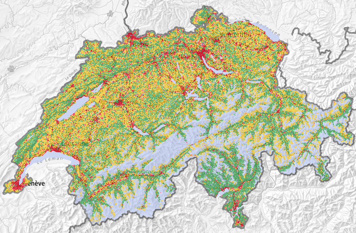
Utilisation du sol selon 72 catégories de base, 17 et 27 classes, et 4 domaines principaux, relevée par interprétation visuelle de points d’échantillonnage distants de 100m et affichés sur des images aériennes digitales en 3 dimensions. Pour la première fois, on relève de manière distincte la couverture et l’utilisation du sol , de sorte que chaque point d'échantillonnage se voit assorti de deux codes. On peut ainsi soit considérer seuls le type de couverture ou le mode d'utilisation, soit combiner ces deux caractères. La nouvelle nomenclature 2004 (NOAS04) compte 72 catégories de base, qui garantissent dans une large mesure la comparabilité avec la nomenclature 1992 (NOAS92).
Semplice
- Altri nomi o acronimi
-
Statistica della superficie standard
- Data (Pubblicazione)
- 2021-10-20
- Identificatore
- ch.bfs.arealstatistik
- Scopo
-
Detaillierte Erhebung der Bodennutzung und -bedeckung der Schweiz mit dem Ziel, deren Zustand und Entwicklung periodisch auszuweisen.
- Stato
- In corso
Punto di contatto
Risoluzione spaziale
- Distanza di risoluzione
- 100 m
- Categoria ISO
-
- A Mappe di base con immagini della copertura terrestre
Estensione
Estensione
- Descrizione
-
Svizzera
))

- Frequenza di aggiornamento
- Annualmente
- Nota sull'aggiornamento
-
Le relevé de la statistique de la superficie 2004/09 a commencé en 2005 et s’est terminé en 2013. Une mise à jour sur la base des images aériennes 2013-18 est actuellement en cours.
- GEMET - INSPIRE themes, version 1.0
-
-
Utilizzo del territorio
-
Copertura del suolo
-
- GEMET
-
-
vegetazione
-
- geocat.ch
-
-
IFDG Infrastruttura federale dei dati geografici
-
opendata.swiss
-
- GEMET
-
-
fotografia aerea (immagine)
-
Vincoli sulle risorse
- Vincoli di accesso
- Diritti di proprietà intellettuale
- Vincoli d'uso
- Altre restrizioni
Risorsa associata
- Titolo
-
Statistica della superficie della Svizzera
- Tipo di associazione
- Citazione di un'opera più ampia
- Lingua
- Deutsch
- Codifica dei caratteri
- UTF8
- Lingua
- Français
- Codifica dei caratteri
- UTF8
- Lingua
- Italiano
- Codifica dei caratteri
- UTF8
- Lingua
- English
- Codifica dei caratteri
- UTF8
- Informazioni supplementari
-
Originalresultate aller neueren Arealstatistiken werden bei GEOSTAT in relationalen Datenbanken verwaltet, in welchen jeder Stichprobenpunkt (die für jeden Erhebungszeitpunkt identisch sind) einen Datenrecord darstellt. Für die Diffusion können daraus gleichermassen strukturierte Textdateien (Normalfall), bei Bedarf aber auch GIS-kompatible Vektor- (Punktdaten) oder Rasterdaten (GRID, GeoTIFF) erzeugt werden.
- Categoria di sottotema
- A1 Mappe di base, modelli paesaggistici
- Categoria di sottotema
- A2 Copertura del suolo, uso del suolo
- Geodati di base
- true
- Identificativo dei geodati di base
-
12.3
- Livello legale dei geodati di base
- Federale
- Formato (codifica)
-
-
TEXT, semicolon separated (CSV)
-
OGC Geopackage (GPKG)
-
Opzioni di trasferimento digitale
- Risorsa online
-
Vorschau map.geo.admin.ch
Opzioni di trasferimento digitale
- Risorsa online
-
Geodata (csv)
Opzioni di trasferimento digitale
- Risorsa online
-
GEOSTAT
GEOSTAT est le centre de compétence pour la géoinformation et le traitement numérique des images digitales de l'OFS.
Opzioni di trasferimento digitale
- Risorsa online
-
Variablenliste
Opzioni di trasferimento digitale
- Risorsa online
-
ch.bfs.arealstatistik
Servizio WMS-IFDG, strato "Statistica della superficie standard"
Opzioni di trasferimento digitale
- Risorsa online
-
ch.bfs.arealstatistik
Servizio WMTS-IFDG, strato "Statistica della superficie standard"
Opzioni di trasferimento digitale
- Risorsa online
-
Geodaten
Opzioni di trasferimento digitale
- Risorsa online
-
Datenbeschreibung
Opzioni di trasferimento digitale
- Risorsa online
-
Fachportal: Bodennutzung, -bedeckung
Opzioni di trasferimento digitale
- Risorsa online
-
RESTful API von geo.admin.ch
RESTful API da geo.admin.ch
- Informazioni generali sulla provenienza
-
Visuelle Interpretation von in einem regelmässigen Gitter von 100 m angeordneten Stichprobenpunkten auf digitalen Luftbildern an einer photogrammetrischen Auswertungsstation anhand eines standardisierten Nutzungskatalogs.
- Livello
- Set di dati
- Descrizione
-
Hauptgrundlage für die Bestimmung der Bodennutzung sind eingescannte, digitalisierte Luftbilder des Bundesamts für Landestopografie (swisstopo) der Jahre 1979-85, 1992-97 sowie 2004-09. Zur Qualitätssicherung und Erleichterung der Interpretation werden soweit verfügbar Zusatzinformationen, beispielsweise Landeskarten, Stadtpläne, Gebäudeinformationen des Eidg. Gebäude- und Wohnungsregisters, Schutzgebiete, Naturkatastrophen und dergleichen beigezogen. Nach der Luftbildinterpretation werden ausgewählte und besonders schwierig zu beurteilende Gebiete und Stichprobenpunkte im Gelände aufgesucht und verifiziert (Feldbegehungen). Für die Durchführung reliefabhängiger geometrischer Korrekturen kommt das Geländemodell DHM25 von swisstopo zum Einsatz.
- Nome del sistema di riferimento
- EPSG:2056
- Frequenza di aggiornamento
- Secondo necessità
- Nota sull'aggiornamento
-
Nachführung erfolgt, wenn Dokumentation fehlerhaft oder verbesserungsbedürftig.
Metadati
- Identificativo della scheda
- 8ac687ee-ad27-4ac7-8c1c-b64abee9e3b3
- Lingua
- Deutsch
- Codifica dei caratteri
- UTF8
- Lingua
- Français
- Codifica dei caratteri
- UTF8
- Lingua
- Italiano
- Codifica dei caratteri
- UTF8
- Lingua
- English
- Codifica dei caratteri
- UTF8
- Lingua
- Rumantsch
- Codifica dei caratteri
- UTF8
Punto di contatto
Tipo di risorsa
- Ambito di applicazione della risorsa
- Set di dati
- Collegamento ai metadati
-
https://www.geocat.ch/geonetwork/srv/api/records/8ac687ee-ad27-4ac7-8c1c-b64abee9e3b3
- Informazioni sulla data (Creazione)
- 2013-10-17T14:04:08Z
- Informazioni sulla data (Revisione)
- 2026-04-13T09:41:36.165081Z
Standard dei metadati
- Titolo
-
eCH-0271