geocat.ch
Amphibien Ausbreitungskarten - Alytes obstetricans
Cartes de dispersion des amphibiens - Alytes obstetricans
Amphibian dispersal maps - Alytes obstetricans
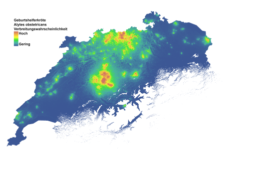
Schweizweite Karte, die die Ausbreitungs-Wahrscheinlichkeit der Geburtshelferkröte (Alytes obstetricans) darstellt. Jede Rasterzelle gibt die relative Wahrscheinlichkeit an, dass sich wandernde Individuen auf ihrem Weg zwischen bekannten Amphibienlaichgebiete durch diesen Hektar wandern. Die Karte zeigt die Ausbreitungs-Wahrscheinlichkeit, die entlang einer Skala von Blau über Gelb bis Rot zunimmt.
Diese Karten sollten als Heatmaps für die Ausbreitungsaktivität bestehender Populationen betrachtet werden. In der Praxis zeigen diese Karten auch Orte, an denen potenzielle neue Amphibienlaichgebiete die höchsten Chancen haben, besiedelt zu werden.
Gebiete mit vielen Populationen in unmittelbarer Nähe erscheinen dunkler rot, was die höhere Wahrscheinlichkeit einer Ausbreitung widerspiegelt, da sich mehrere Ausbreitungsrouten zwischen den Populationen überschneiden. Diese Eigenschaft der Karten verdient besondere Aufmerksamkeit. Hellere Schattierungen an den Rändern der Artenverbreitung bedeuten nicht unbedingt eine schwächere Verbindung zwischen den Populationen, sondern sind eher eine Folge der geringeren Dichte an Amphibienlaichgebieten an den Rändern der Verbreitung. Die Farbskala soll im Kontext der unmittelbaren Umgebung betrachtet werden.
Die Ausbreitungskarte wurde mit Circuitscape berechnet und basiert auf einer Landschaftswiderstandsmatrix, die aus dem am besten bewerteten Verbreitungsmodell für jede Art abgeleitet wurde.
Für Details, siehe die beigefügte Datenbeschreibung.
LIteratur:
Churko G., Szerencsits E., Aldrich A., Schmidt B. R. (2024). Spatial analysis of the potential exposure of amphibians to plant protection products at the landscape scale. Basic and Applied Ecology, 76, 14-24. https://doi.org/10.1016/j.baae.2024.02.004
Carte de la Suisse montrant la probabilité de dispersion du Crapaud accoucheur (Alytes obstetricans). Chaque cellule de la grille indique la probabilité relative que des individus traversent cet hectare sur leur trajet entre des sites de reproduction connus. La carte montre la probabilité de dispersion qui augmente le long d'une échelle allant du bleu au rouge en passant par le jaune.
Ces cartes devraient être considérées comme des cartes de chaleur de l'activité de dispersion des populations existantes. En pratique, ces cartes indiquent également les endroits où les nouveaux sites de reproduction d'amphibiens potentiels ont le plus de chances d'être colonisés.
Les zones avec de nombreuses populations à proximité immédiate apparaissent en rouge plus foncé, ce qui reflète une plus grande probabilité de dispersion, car plusieurs voies de dispersion entre les populations se chevauchent. Cette caractéristique des cartes mérite une attention particulière. Des nuances plus claires sur les bords de la distribution des espèces ne signifient pas nécessairement un lien plus faible entre les populations, mais sont plutôt la conséquence d'une densité plus faible de sites de reproduction d'amphibiens sur les bords de la distribution. L'échelle de couleurs doit être considérée dans le contexte de l'environnement immédiat.
La carte de dispersion a été calculée avec Circuitscape et se base sur une matrice de résistance du paysage dérivée du MDS le mieux évalué pour chaque espèce.
Pour plus de détails, voir la description des données ci-jointe.
Litérature:
Churko G., Szerencsits E., Aldrich A., Schmidt B. R. (2024). Spatial analysis of the potential exposure of amphibians to plant protection products at the landscape scale. Basic and Applied Ecology, 76, 14-24. https://doi.org/10.1016/j.baae.2024.02.004
Swiss-wide map depicting the dispersal probability of the Midwife toad (Alytes obstetricans). Each grid cell indicates the relative probability that dispersing individuals will pass through that hectare on their way between known amphibian breeding sites. The map shows dispersal probability increasing along a scale from blue to yellow to red.
These maps should be thought of as heatmaps for dispersal activity of existing populations. In practical terms, these maps also show locations where potential new amphibian breeding sites have the highest chances of being colonized.
Areas with many populations in close proximity appear a darker red, reflecting the higher probability of dispersal as multiple dispersal routes between populations intersect. This feature of the maps deserves special attention. Lighter shades at the edges of the species' range do not necessarily indicate a weaker connection between populations, but rather a consequence of the lower density of breeding sites at the edges of the range. The color scale should be considered in the context of the immediate surroundings.
The dispersal map was calculated using Circuitscape and is based on a landscape resistance matrix derived from the best-ranked dispersal model for each species.
For details, see the attached data description.
Literature:
Churko G., Szerencsits E., Aldrich A., Schmidt B. R. (2024). Spatial analysis of the potential exposure of amphibians to plant protection products at the landscape scale. Basic and Applied Ecology, 76, 14-24. https://doi.org/10.1016/j.baae.2024.02.004
Simple
-
Autre titreAltri nomi o acronimiAlternate titleAlternate titleAlternativtitel
-
Ausbreitungskarte Alytes obstericans
Cartes de dispersion Alytes obstetricans
Dispersal maps - Alytes obstetricans
-
Date (Publication)Data (Pubblicazione)Date (Publication)Date (Publication)Datum (Publikation)
- 2024-02-23
-
IdentifiantIdentificatoreIdentifierIdentifierKennung
- ch.agroscope.Amphibien_Ausbreitungskarten_Alytes_obstericans
-
ÉtatStatoStatusStatusBearbeitungsstatus
-
TerminéCompletatoCompletedCompletedAbgeschlossen
Auteur
Autore
Author
Author
Autor
Auteur principal de la recherche
Ricercatore principale
Principal investigator
Principal investigator
Projektleiter
Point de contact
Punto di contatto
Point of contact
Point of contact
Ansprechpartner
-
Type de représentation spatialeTipo di rappresentazione spazialeSpatial representation typeSpatial representation typeRäumliche Darstellungsart
-
grilleRasterGridGridRaster, Gitter
Résolution spatiale
Risoluzione spaziale
Spatial resolution
Spatial resolution
Räumliche Auflösung
-
Distance de résolutionDistanza di risoluzioneSpatial resolutionSpatial resolutionDistanz
- 100 m
-
Catégorie de thèmeCategoria ISOTopic categoryTopic categoryThematik
-
-
G BioteG BiotaG BiotaG BiotaG Biologie
-
L EnvironnementL AmbienteL EnvironmentL EnvironmentL Umwelt
-
S ÉlevageS AgricolturaS FarmingS FarmingS Landwirtschaft
-
Étendue
Estensione
Extent
Extent
Ausdehnung
Étendue
Estensione
Extent
Extent
Ausdehnung
-
DescriptionDescrizioneDescriptionDescriptionBeschreibung
-
Switzerland
Schweiz
Suisse
Svizzera
Svizra
))

-
Fréquence de mise à jourFrequenza di aggiornamentoMaintenance and update frequencyMaintenance and update frequencyWartungsintervall
-
Non planifiéeNon pianificatoNot plannedNot plannedNicht geplant
Dépositaire
Custode
Custodian
Custodian
Verwalter
Format de la ressource
Formato della risorsa
Resource format
Resource format
Format der Ressource
-
TitreTitoloTitleTitleTitel
-
Tagged Image File Format (TIFF)
-
DateDataDateDateDatum
Format de la ressource
Formato della risorsa
Resource format
Resource format
Format der Ressource
-
TitreTitoloTitleTitleTitel
-
Cloud Optimized GeoTIFF (TIFF / TIF)
-
DateDataDateDateDatum
-
ÉditionEdizioneEditionEditionAusgabe
-
-
- GEMET themes
-
-
agriculture
agricoltura
agriculture
-
zones naturelles, paysages, écosystèmes
aree naturali, paesaggio, ecosistemi
natural areas, landscape, ecosystems
-
- GEMET
-
-
faune
fauna
fauna
-
préservation de la nature
conservazione della natura
nature conservation
-
batracien
anfibi
amphibian
-
agriculture
agricoltura
agriculture
-
- geocat.ch
-
-
confédération
confederazione
confederation
-
opendata.swiss
opendata.swiss
opendata.swiss
opendata.swiss
-
IFDG l’Infrastructure Fédérale de données géographiques
IFDG Infrastruttura federale dei dati geografici
FSDI Federal Spatial Data Infrastructure
-
Contraintes sur la ressource
Vincoli sulle risorse
Resource constraints
Resource constraints
Ressourcenbeschränkungen
-
Contraintes d'accèsVincoli di accessoAccess constraintsAccess constraintsZugriffsbeschränkungen
-
Droit d’auteurCopyrightCopyrightCopyrightUrheberrecht
-
Contraintes d'utilisationVincoli d'usoUse constraintsUse constraintsNutzungseinschränkungen
-
Droit d’auteurCopyrightCopyrightCopyrightUrheberrecht
-
Autres contraintesAltri vincoliOther constraintsOther constraintsAndere Einschränkungen
- Opendata OPEN: Freie Nutzung.Opendata OPEN: Utilisation libre.Opendata OPEN: Libero utilizzo.Opendata OPEN: Open use.
Ressource associée
Risorsa associata
Associated resource
Associated resource
Verlinkte Ressource
-
TitreTitoloTitleTitleTitel
-
-- Bezeichnung gemäss: «Bezeichnung GeoIV» (in GeoIV Anhang 1, Spalte B) --
-- Appellation selon: "Désignation OGéo" (dans OGéo, annexe 1, colonne B) --
-- Denominazione in conformità a: "Raccolta dei geodati di base di diritto federale" --
-
Type d'associationTipo di associazioneAssociation TypeAssociation TypeAssoziationstyp
-
Citation de travail plus largeCitazione di un'opera più ampiaReference to a master resource of which this one is a partReference to a master resource of which this one is a partÜbergeordneter Datenbestand
-
LangueLinguaLanguageLanguageSprache
- Deutsch
-
Encodage de caractèresCodifica dei caratteriCharacter encodingCharacter encodingZeichenkodierung
-
Utf8UTF8UTF8UTF8Utf8
-
Catégorie de sous-thèmeCategoria di sottotemaSubtopic CategorySubtopic CategoryThematische Unterkategorien
-
L2 Protection de la nature et du paysageL2 Protezione della natura e del paesaggioL2 Nature and Landscape ProtectionL2 Nature and Landscape ProtectionL2 Natur- und Landschaftsschutz
-
Géodonnées de baseGeodati di baseBasic GeodataBasic GeodataGeobasisdaten
- false
-
Niveau des géodonnées de baseLivello legale dei geodati di baseBasic Geodata Legal LevelBasic Geodata Legal LevelGeobasisdatenebene
-
FédéralFederaleFederalFederalNational
-
Type de géodonnées de baseTipo di geodati di baseBasic Geodata TypeBasic Geodata TypeGeobasisdatentyp
-
openDataopenDataopenDataopenDataopenData
-
Format de distributionFormato (codifica)Distribution formatDistribution formatAbgabeformat
-
-
Cloud Optimized GeoTIFF (TIFF / TIF)
-
Propriétaire
Proprietario
Owner
Owner
Eigentümer
Distributeur
Distributore
Distributor
Distributor
Verteiler
Options de transfert numérique
Opzioni di trasferimento digitale
Digital transfer options
Digital transfer options
Optionen für die digitale Übertragung
-
Ressource en ligneRisorsa onlineOnLine resourceOnLine resourceOnline
-
DescriptionDonnees_BatrachiensAgricole.pdf
Options de transfert numérique
Opzioni di trasferimento digitale
Digital transfer options
Digital transfer options
Optionen für die digitale Übertragung
-
Ressource en ligneRisorsa onlineOnLine resourceOnLine resourceOnline
-
Datenbeschreibung_AmphibienAckerland.pdf
Options de transfert numérique
Opzioni di trasferimento digitale
Digital transfer options
Digital transfer options
Optionen für die digitale Übertragung
-
Ressource en ligneRisorsa onlineOnLine resourceOnLine resourceOnline
-
ch.agroscope.amphibien-ausbreitungskarten_alytes_obstetricans
WMS-BGDI Dienst, Layer "Ausbreitungskarte Alytes obstericans"Service WMS-IFDG, couche "Cartes de dispersion Alytes obstetricans"Servizio WMS-IFDG, strato "Cartes de dispersion Alytes obstetricans"WMS-FSDI service, layer "Dispersal maps - Alytes obstetricans"WMS-BGDI Dienst, Layer "Ausbreitungskarte Alytes obstericans"
Options de transfert numérique
Opzioni di trasferimento digitale
Digital transfer options
Digital transfer options
Optionen für die digitale Übertragung
-
Ressource en ligneRisorsa onlineOnLine resourceOnLine resourceOnline
-
ch.agroscope.amphibien-ausbreitungskarten_alytes_obstetricans
WMTS-BGDI Dienst, Layer "Ausbreitungskarte Alytes obstericans"Service WMTS-IFDG, couche "Cartes de dispersion Alytes obstetricans"Servizio WMTS-IFDG, strato "-"WMTS-FSDI service, layer "Dispersal maps - Alytes obstetricans"WMTS-BGDI Dienst, Layer "Ausbreitungskarte Alytes obstericans"
Options de transfert numérique
Opzioni di trasferimento digitale
Digital transfer options
Digital transfer options
Optionen für die digitale Übertragung
-
Ressource en ligneRisorsa onlineOnLine resourceOnLine resourceOnline
-
Vorschau map.geo.admin.ch
Options de transfert numérique
Opzioni di trasferimento digitale
Digital transfer options
Digital transfer options
Optionen für die digitale Übertragung
-
Ressource en ligneRisorsa onlineOnLine resourceOnLine resourceOnline
-
STAC Browser
Link zum DownloadLien pour l’obtention des donnéesLink to data access
Options de transfert numérique
Opzioni di trasferimento digitale
Digital transfer options
Digital transfer options
Optionen für die digitale Übertragung
-
Ressource en ligneRisorsa onlineOnLine resourceOnLine resourceOnline
-
Vorschau bei map.geo.admin.ch
Vorschau bei map.geo.admin.chPrévisualisation des donnéesData preview
Options de transfert numérique
Opzioni di trasferimento digitale
Digital transfer options
Digital transfer options
Optionen für die digitale Übertragung
-
Ressource en ligneRisorsa onlineOnLine resourceOnLine resourceOnline
-
ch.agroscope.Amphibien_Ausbreitungskarten_Alytes_obstericans
WMS-BGDI Dienst, Layer "Ausbreitungskarten Alytes obstericans"Service WMS-BGDI, Layer "Amphibien Ausbreitungskarten -Alytes obstericans"WMS-BGDI service, Layer "Amphibien Ausbreitungskarten -Alytes obstericans"
Options de transfert numérique
Opzioni di trasferimento digitale
Digital transfer options
Digital transfer options
Optionen für die digitale Übertragung
-
Ressource en ligneRisorsa onlineOnLine resourceOnLine resourceOnline
-
ch.agroscope.Amphibien_Ausbreitungskarten_Alytes_obstericans
WMTS-BGDI Dienst, Layer "Ausbreitungskarte Alytes obstericans"Service WMS-BGDI, Layer "Amphibien Ausbreitungskarten -Alytes obstericans"WMS-BGDI service, Layer "Amphibien Ausbreitungskarten -Alytes obstericans"
-
Type d’objet géométriqueTipo di oggetto geometricoGeometric object typeGeometric object typeTyp des geometrischen Objekts
-
PolygoneSuperficieSurfaceSurfacesurface
-
Nom du système de référenceNome del sistema di riferimentoReference system identifierReference system identifierName des Referenzsystems
- LV95 EPSG:2056
-
Fréquence de mise à jourFrequenza di aggiornamentoMaintenance and update frequencyMaintenance and update frequencyWartungsintervall
-
Comme nécessaireSecondo necessitàAs neededAs neededBei Bedarf
Metadata
-
Identifiant des métadonnéesIdentificativo della schedaMetadata identifierMetadata identifierIdentifikator des Metadatensatzes
- 89ec47fa-79e1-4b89-b490-50d1f9e0069b
-
LangueLinguaLanguageLanguageSprache
- Deutsch
-
Encodage de caractèresCodifica dei caratteriCharacter encodingCharacter encodingZeichenkodierung
-
Utf8UTF8UTF8UTF8Utf8
-
LangueLinguaLanguageLanguageSprache
- Français
-
Encodage de caractèresCodifica dei caratteriCharacter encodingCharacter encodingZeichenkodierung
-
Utf8UTF8UTF8UTF8Utf8
-
LangueLinguaLanguageLanguageSprache
- Italiano
-
Encodage de caractèresCodifica dei caratteriCharacter encodingCharacter encodingZeichenkodierung
-
Utf8UTF8UTF8UTF8Utf8
-
LangueLinguaLanguageLanguageSprache
- English
-
Encodage de caractèresCodifica dei caratteriCharacter encodingCharacter encodingZeichenkodierung
-
Utf8UTF8UTF8UTF8Utf8
-
LangueLinguaLanguageLanguageSprache
- Rumantsch
-
Encodage de caractèresCodifica dei caratteriCharacter encodingCharacter encodingZeichenkodierung
-
Utf8UTF8UTF8UTF8Utf8
Propriétaire
Proprietario
Owner
Owner
Eigentümer
Type de ressource
Tipo di risorsa
Type of resource
Type of resource
Anwendungsbereich der Metadaten
-
Domaine d'application de la ressourceAmbito di applicazione della risorsaResource scopeResource scopeDomäne der Ressourcenanwendung
-
Jeu de donnéesSet di datiDatasetDatasetDatenbestand
-
Lien vers la métadonnéeCollegamento ai metadatiMetadata linkageMetadata linkageLink zu den Metadaten
-
Informations de date (Création)Informazioni sulla data (Creazione)Date info (Creation)Date info (Creation)Datumsangaben (Erstellung)
- 2024-02-21T09:52:56.123Z
-
Informations de date (Révision)Informazioni sulla data (Revisione)Date info (Revision)Date info (Revision)Datumsangaben (Aktualisierung)
- 2026-04-27T09:25:21.791585Z
Norme des métadonnées
Standard dei metadati
Metadata standard
Metadata standard
Metadatenstandard
-
TitreTitoloTitleTitleTitel
-
eCH-0271