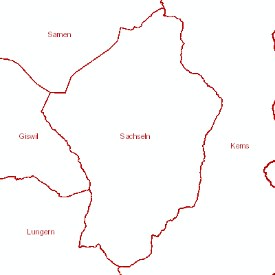
Administrative Einteilungen (amtliche Vermessung) (Sachseln, OW)
Der Geobasisdatensatz enthält die Nummerierungsbereiche, politische und administrative Grenzen; Planeinteilung; Toleranzstufen; Rutschung und spannungsarme Gebiete.
Simple
Identification info
- Date (Creation)
- 1990-01-01
- Date (Revision)
- 2025-12-16
- Citation identifier
- sc_dm01
- Status
- On going
Point of contact
Responsible party
- Organisation name
-
Kanton Obwalden, Volkswirtschaftsamt (VWA)
- Voice
-
+41 41 666 62 21
Address
- Delivery point
-
St. Antonistrasse 4
- City
-
Sarnen
- Postal code
-
6061
- Electronic mail address
- Website
-
Webseite Volkswirtschaftsamt
(
WWW:LINK
)
Das Volkswirtschaftsamt führt das Handelsregister und die Stiftungsaufsicht mit Ausnahme der BVG-Vorsorgeeinrichtungen. Es ist die statistische Anlaufstelle und Bewilligungsbehörde für den Erwerb von Grundstücken durch Personen im Ausland. Die Abteilung Grundbuch führt in Sarnen und Engelberg das Grundbuch und ist für die Grundbuchbereinigung besorgt. Das Volkswirtschaftsamt setzt die Neue Regionalpolitik des Bundes um, unterstützt überkantonale Träger des Tourismus und ist Koordinationsstelle für Fragen der Welthandelsabkommen (GATT/GATS/TRIPS). Es ist Anlaufstelle für die Submission und den Binnenmarkt und richtet Beiträge für die Wohnbau- und Eigentumsförderung aus. Das Volkswirtschaftsamt ist darüber hinaus für die Angebotsbestellung im Bereich des öffentlichen Verkehrs zuständig sowie mit den Aufgaben der amtlichen Vermessung und dem amtlichen Teil von GIS Obwalden betraut.
- Hours of service
-
Mo-Fr 08.00-11.45, 13.30-17.00
- Role
- Owner
- Last Name
-
Kanton Obwalden, Volkswirtschaftsamt (VWA)
- Organisation Acronym
-
VWA
- Maintenance and update frequency
- Continual
-
GEMET
-
-
administrative boundary
-
-
geocat.ch
-
-
administrative division
-
cadastral surveying
-
plan division
-
political boundary
-
slide
-
tolerance level
-
- Access constraints
- Other restrictions
- Use constraints
- Other restrictions
- Other constraints
- Die Geodaten sind öffentlich zugänglich (Zugangsberechtigungsstufe A gemäss GeoIV Art. 21).
- Spatial representation type
- Vector
- Language
- Deutsch
- Character set
- UTF8
- Topic category
-
- A Base Maps, Land Cover, Aerial and Satellite Imagery
- A1 Base Maps, Landscape Models
- D Political and Administrative Boundaries
- Environment description
-
Adalin
Extent
- Description
-
Sachseln
))

- Basic geodata identifier
-
63.1
- Basic geodata identifier type
- Bund
- Distribution format
-
-
INTERLIS
(
-
)
-
andere Formate auf Anfrage
(
-
)
-
INTERLIS
(
-
)
Distributor contact
Responsible party
- Organisation name
-
GIS Daten AG Sarnen
- Voice
-
+41 41 660 80 33
Address
- Delivery point
-
Grundacher 1
- City
-
Sarnen
- Postal code
-
6060
- Electronic mail address
-
sarnen@gis-daten.ch
- Website
- Webseite GIS Daten AG ( WWW:LINK )
- Role
- Distributor
- Last Name
-
GIS Daten AG Sarnen
- OnLine resource
-
Geoshop OW
(
WWW:DOWNLOAD-URL
)
Datenbezug
- OnLine resource
-
WMS-Dienst geodienste.ch
(
OGC:WMS
)
WMS-Dienst geodienste.ch
- OnLine resource
-
Geodienste.ch
(
WWW:DOWNLOAD-URL
)
Datenbezug
- OnLine resource
- Geobasisdatenkatalog ( WWW:LINK )
- OnLine resource
- Webkarte mit administrativen Informationen ( WWW:LINK )
Metadata
- Metadata language
- Deutsch
- Character set
- UTF8
- Parent identifier
-
Administrative Einteilungen (amtliche Vermessung) (OW)
85126E7E-448D-4AF2-8E76-10BF2B650E18
- Hierarchy level
- Dataset
- Date stamp
- 2025-05-13T14:50:43.000Z
- Metadata standard name
-
GM03_2
Metadata author
Responsible party
- Organisation name
-
GIS Daten AG Sarnen
- Voice
-
+41 41 660 80 33
Address
- Delivery point
-
Grundacher 1
- City
-
Sarnen
- Postal code
-
6060
- Electronic mail address
-
sarnen@gis-daten.ch
- Website
- Webseite GIS Daten AG ( WWW:LINK )
- Role
- Custodian
- Last Name
-
GIS Daten AG Sarnen
 geocat.ch


