geocat.ch
Gefahrenkarten (Gefahrenkartierung) (OW)
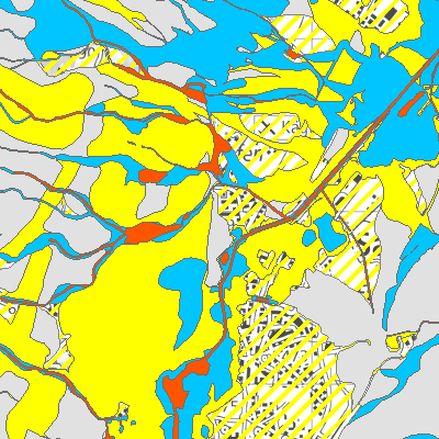
Für die besiedelten Gebiete wurden detaillierte Gefahrenkarten für die Gefahrenprozesse (Wildbach/Rutschung/Hochwasser, Sturz, Lawine) ausgearbeitet.
Die Synoptische Karte zeigt die Überlagerung aller verfügbaren Gefahrenprozesse.
Die Gefahrenkarte ist behördenverbindlich!
Simple
- Alternate title
-
Gefahrenkarten (behördenverbindlich)
- Date (Creation)
- 2005-07-07
- Date (Revision)
- 2026-04-02
- Identifier
- ow_gefahrenbeurteilung
- Status
- On going
Owner
Die Abteilung Naturgefahren erkennt und beurteilt Risiken von Naturgefahren. Sie reduziert die Risiken in Zusammenarbeit mit den Gemeinden, Wuhrgenossenschaften, Korporationen und dem Bund. Zudem übt sie die Oberaufsicht über die Gewässer und die Aufsicht über Stauanlagen aus.
- Hours of service
-
MO-FR 08.00-11.45 Uhr, 13.30-17.00 Uhr
- Spatial representation type
- Vector
- Topic category
-
- F Geoscientific information
Extent
Extent
- Description
-
Canton of Obwalden (OW)
))

- Maintenance and update frequency
- As needed
- GEMET
-
-
water (geographic)
-
flood
-
water science
-
avalanche
-
avalanche protection
-
detection
-
natural hazard
-
natural risk
-
lake
-
environment
-
- geocat.ch
-
-
doline
-
river
-
hazard map
-
debris flow
-
natural hazard map
-
slide
-
rockfall process
-
torrent
-
Resource constraints
- Access constraints
- Other restrictions
- Use constraints
- Other restrictions
- Other constraints
- Die Geodaten sind öffentlich zugänglich (Zugangsberechtigungsstufe A gemäss GeoIV Art. 21).
- Language
- Deutsch
- Character encoding
- UTF8
- Environment description
-
ArcGIS Pro
- Subtopic Category
- F3 Natural Hazards
- Basic Geodata
- true
- Basic Geodata ID
-
166.1
- Basic Geodata Legal Level
- Bund
- Distribution format
-
-
INTERLIS
-
andere Formate auf Anfrage
-
Distributor
Digital transfer options
- OnLine resource
-
Geobasisdatenkatalog
Digital transfer options
- OnLine resource
-
Webkarte Gefahren (synoptisch)
Identifier
- Code
- 2056
Metadata
- Metadata identifier
- 87E8DBC9-92F7-40DF-BFF2-E0A84270BA84
- Language
- Deutsch
- Character encoding
- UTF8
- Language
- Français
- Character encoding
- UTF8
- Language
- English
- Character encoding
- UTF8
- Language
- Italiano
- Character encoding
- UTF8
Custodian
Type of resource
- Resource scope
- Dataset
- Date info (Revision)
- 2026-05-12T13:10:54.000Z
Metadata standard
- Title
-
GM03_2