geocat.ch
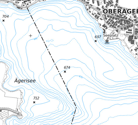
Isobathen - Seebodenkurven (ZG)
Der Datensatz zeigt Isobathen, also Tiefenlinien des Seegrundes, für die Gewässer im Kanton Zug. Die Linien wurden aus einem Unterwasser-Geländemodell abgeleitet. Dieses basiert auf Messungen mit Fächerecholot sowie bathymetrischem LIDAR im Flachwasserbereich unter 5 m. Der Datensatz dient der Darstellung und Analyse der Seetopografie, etwa für Gewässerbewirtschaftung, Planung, Vermessung und Fachauswertungen.
Simple
-
Date (Création)Data (Creazione)Date (Creation)Datum (Erstellung)
- 2017-01-09
-
ÉtatStatoStatusBearbeitungsstatus
-
TerminéCompletatoCompletedAbgeschlossen
Propriétaire
Proprietario
Owner
Eigentümer
-
Heures de serviceOrario di servizioHours of serviceBetriebszeiten
-
08:00-11:45, 13:30-17:00
-
Type de représentation spatialeTipo di rappresentazione spazialeSpatial representation typeRäumliche Darstellungsart
-
vecteurVettorialeVectorVektor
-
Catégorie de thèmeCategoria ISOTopic categoryThematik
-
-
C ÉlévationC AltitudineC ElevationC Höhenangaben
-
Étendue
Estensione
Extent
Ausdehnung
Étendue
Estensione
Extent
Ausdehnung
-
DescriptionDescrizioneDescriptionBeschreibung
-
Canton of Zug (ZG)
Kanton Zug (ZG)
Canton de Zoug (ZG)
Cantone di Zugo (ZG)
))

-
Fréquence de mise à jourFrequenza di aggiornamentoMaintenance and update frequencyWartungsintervall
-
InconnueSconosciutoUnknownUnbekannt
- geocat.ch
-
-
courbe des fonds des lacs
quota altimetrica dei laghi
contour in lakes
-
point altimétrique
punto quotato
spot elevation
-
courbe de niveau
curva di livello
contour line
-
LIDAR (Light Detection And Ranging)
LIDAR (Light Detection And Ranging)
LIDAR (Light Detection And Ranging)
-
MNA (modèle numérique d'altitude)
DEM (modello digitale di elevazione)
DEM (digital elevation model)
-
- GEMET
-
-
lac
lago
lake
-
niveau d'eau
livello dell'acqua
water level
-
Contraintes sur la ressource
Vincoli sulle risorse
Resource constraints
Ressourcenbeschränkungen
-
Contraintes d'accèsVincoli di accessoAccess constraintsZugriffsbeschränkungen
-
RestreintRiservatoRestrictedBeschränkter Zugang
-
LangueLinguaLanguageSprache
- Deutsch
-
Format de distributionFormato (codifica)Distribution formatAbgabeformat
-
-
OGC Web Feature Service (WFS)
-
AutoCAD DXF (DXF)
-
OGC Geopackage (GPKG)
-
ESRI Shapefile (SHP)
-
Options de transfert numérique
Opzioni di trasferimento digitale
Digital transfer options
Optionen für die digitale Übertragung
-
Ressource en ligneRisorsa onlineOnLine resourceOnline
-
Höhenkurven und Isobathen
Options de transfert numérique
Opzioni di trasferimento digitale
Digital transfer options
Optionen für die digitale Übertragung
-
Ressource en ligneRisorsa onlineOnLine resourceOnline
-
Isobathen
Options de transfert numérique
Opzioni di trasferimento digitale
Digital transfer options
Optionen für die digitale Übertragung
Identifiant
Identificativo
Identifier
Identifikator
-
CodeCodiceCodeCode
- EPSG:2056
-
DescriptionDescrizioneDescriptionBeschreibung
-
CH1903+ / LV95 (EPSG:2056)
-
Type de système de référencesTipo di sistema di riferimentoReference system typeArt des Referenzsystems
Metadata
-
Identifiant des métadonnéesIdentificativo della schedaMetadata identifierIdentifikator des Metadatensatzes
- 8791f570-4a60-4bdd-9331-fd3deaf81e50
-
LangueLinguaLanguageSprache
- Deutsch
-
Encodage de caractèresCodifica dei caratteriCharacter encodingZeichenkodierung
-
Utf8UTF8UTF8Utf8
-
LangueLinguaLanguageSprache
- Français
-
Encodage de caractèresCodifica dei caratteriCharacter encodingZeichenkodierung
-
Utf8UTF8UTF8Utf8
-
LangueLinguaLanguageSprache
- Italiano
-
Encodage de caractèresCodifica dei caratteriCharacter encodingZeichenkodierung
-
Utf8UTF8UTF8Utf8
-
LangueLinguaLanguageSprache
- English
-
Encodage de caractèresCodifica dei caratteriCharacter encodingZeichenkodierung
-
Utf8UTF8UTF8Utf8
Distributeur
Distributore
Distributor
Verteiler
-
Heures de serviceOrario di servizioHours of serviceBetriebszeiten
-
08:00-11:45, 13:30-17:00
Type de ressource
Tipo di risorsa
Type of resource
Anwendungsbereich der Metadaten
-
Domaine d'application de la ressourceAmbito di applicazione della risorsaResource scopeDomäne der Ressourcenanwendung
-
Jeu de donnéesSet di datiDatasetDatenbestand
-
Informations de date (Création)Informazioni sulla data (Creazione)Date info (Creation)Datumsangaben (Erstellung)
- 2017-04-10T11:04:15Z
-
Informations de date (Révision)Informazioni sulla data (Revisione)Date info (Revision)Datumsangaben (Aktualisierung)
- 2026-06-17T12:29:56.563063Z
Norme des métadonnées
Standard dei metadati
Metadata standard
Metadatenstandard
-
TitreTitoloTitleTitel
-
eCH-0271