geocat.ch
swissBOUNDARIES3D
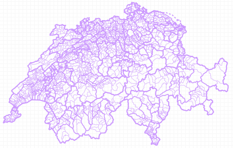
swissBOUNDARIES3D contains all administrative units and national boundaries of Switzerland and the Principality of Liechtenstein in vector form. The product is based on an optimized data model for Switzerland and conforms to the data of the Swiss Federal Statistical Office. swissBOUNDARIES3D replaces the GG25 dataset from 2010 onwards.
Simple
- Alternate title
-
swissBOUNDARIES3D
- Date (Publication)
- 2026-01-01
- Identifier
- ch.swisstopo.swissboundaries3d
Point of contact
Owner
Spatial resolution
Equivalent scale
- Denominator
- 10000
- Topic category
-
- D Boundaries
Extent
Extent
- Description
-
Switzerland
))

Extent
Extent
- Description
-
Liechtenstein
))

- Maintenance and update frequency
- Annually
- Maintenance note
-
swissBOUNDARIES3D is updated annually. Updating is based on the information of the Cadastral Surveying (CS) and the Federal Statistical Office (FSO).
- Duration of Conservation
- 275
- Appraisal of Archival Value
- A
- Reason for Archiving Value
- Evidence of business practice
- geocat.ch
-
-
national border
-
district
-
official geodata
-
opendata.swiss
-
Conservation and archiving planning AAP - Confederation
-
- GEMET - INSPIRE themes, version 1.0
-
-
Administrative units
-
- GEMET
-
-
municipality
-
- geocat.ch
-
-
FSDI Federal Spatial Data Infrastructure
-
- geocat.ch
-
-
canton
-
- GEMET
-
-
administrative boundary
-
- GEMET
-
-
administrative boundary
-
Resource constraints
- Other constraints
- Opendata BY: Open use. Must provide the source.
Associated resource
- Title
-
Administrative boundaries (national survey)
- Association Type
- Reference to a master resource of which this one is a part
- Language
- Deutsch
- Character encoding
- UTF8
- Language
- Français
- Character encoding
- UTF8
- Language
- English
- Character encoding
- UTF8
- Basic Geodata
- true
- Basic Geodata ID
-
39.3
- Basic Geodata Legal Level
- Federal
- Basic Geodata Type
- Reference Geodata
- Included with dataset
- 0
- Title
-
swissBOUNDARIES3D Grenzen Schweizweit in 3D
- Date (Publication)
- 2026-01-01
- Distribution format
-
-
ESRI Shapefile (SHP)
-
ESRI File Geodatabase FileGDB (GDB)
-
AutoCAD DXF (DXF)
-
INTERLIS 2 (XTF)
-
OGC Geopackage (GPKG)
-
Digital transfer options
Digital transfer options
- OnLine resource
-
map.geo.admin.ch
- Geometric object type
- Curve
- Geometric object type
- Surface
- Reference system identifier
- EPSG:2056
Metadata
- Metadata identifier
- 86cb844f-296b-40cb-b972-5b1ae8028f7c
- Language
- Deutsch
- Character encoding
- UTF8
- Language
- Français
- Character encoding
- UTF8
- Language
- Italiano
- Character encoding
- UTF8
- Language
- English
- Character encoding
- UTF8
- Language
- Rumantsch
- Character encoding
- UTF8
Point of contact
Type of resource
- Resource scope
- Dataset
- Metadata linkage
-
https://www.geocat.ch/geonetwork/srv/api/records/86cb844f-296b-40cb-b972-5b1ae8028f7c
- Date info (Creation)
- 2011-01-24T14:02:02Z
- Date info (Revision)
- 2026-04-13T09:21:02.308192Z
Metadata standard
- Title
-
eCH-0271