 geocat.ch
Versickerungszonen
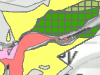
Die Versickerungskarte des Kantons Bern mit den Versickerungszonen (VSZ) dient Ingenieuren, Architekten und den Behörden bei der Planung der Entwässerung ihrer Bauvorhaben. Sie gibt einen ersten Anhaltspunkt, ob und wie eine Regenabwasserversickerung im Überbauungsgebiet realisierbar ist und in welchen Gebieten hohe Grundwasserspiegel beachtet werden müssen.
Die Versickerungskarte beinhaltet aber lediglich generelle, regionale Informationen. Für die Detailprojektierung sind daher zwingend lokale, projektspezifische hydrogeologische Abklärungen von einer Fachperson (Geologe, Hydrogeologe oder spezialisierter Ingenieur) vorzunehmen.
Simple
- Date (Creation)
- 2011-09-30
- Date (Revision)
- 2026-01-14
- Date (Publication)
- 2026-01-22
- Identifier
- VSZ
- Status
- On going
Owner
Principal investigator
Principal investigator
- Topic category
-
- I Inland waters
Extent
Extent
- Description
- Kanton Bern (reduziert) Canton de Berne (réduit)
))
- Maintenance and update frequency
- Biannually
- Keywords
-
-
Zoneneinteilung
-
Versickerung
-
opendata.swiss
-
Resource constraints
- Use limitation
-
Auf sämtlichen Plots und Publikationen ist der Vermerk "Versickerungszonen © Amt für Wasser und Abfall des Kantons Bern; Gemeinden des Kantons Bern" anzugeben.
Resource constraints
- Use constraints
- Licence End User
- Other constraints
- Die Daten dürfen gemäss Nutzungsbedingungen frei genutzt werden. Les données peuvent être utilisées librement selon les conditions d’utilisation.
Resource constraints
- Other constraints
- Freie Nutzung. Quellenangabe ist Pflicht. Utilisation libre. Obligation d’indiquer la source.
- Language
- Deutsch
- Character encoding
- UTF8
- Language
- Français
- Character encoding
- UTF8
- Language
- Italiano
- Character encoding
- UTF8
- Language
- English
- Character encoding
- UTF8
- Basic Geodata
- true
- Basic Geodata ID
-
29-BE
- Basic Geodata Legal Level
- Communal
- Included with dataset
- false
- Distribution format
-
-
SHP
-
GPKG
-
GeoParquet
-
Digital transfer options
- Transfer size
- 8227164
- OnLine resource
-
ZIP-Datei mit Shapefile, Metadaten und Begleitdaten
Digital transfer options
- Transfer size
- 8164405
- OnLine resource
-
ZIP-Datei mit Geopackage mit Metadaten
Digital transfer options
- Transfer size
- 5786035
- OnLine resource
-
Geoparquet-Datei - Versickerungszonen
Digital transfer options
- OnLine resource
-
STAC-Collection - VSZ
Digital transfer options
- OnLine resource
-
Link zum Geoportal des Kantons Bern
- Reference system identifier
- CH1903+ / LV95 -- Swiss CH1903+ / LV95/EPSG:2056
Metadata
- Metadata identifier
- 8205ef5d-db51-494b-a5ba-9c42339170ac
- Language
- Deutsch
- Character encoding
- UTF8
- Language
- Français
- Character encoding
- UTF8
Point of contact
Type of resource
- Resource scope
- Dataset
- Name
-
Geoprodukt - Géoproduit
- Date info (Creation)
- 2011-09-30T00:00:00Z
- Date info (Revision)
- 2026-01-22T00:00:00Z
Metadata standard
- Title
-
GM03 2+
)))