geocat.ch
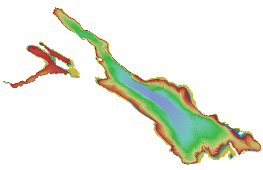
swissBATHY3D Hillshade : Bathymetric data
This representation is derived from the swissBATHY3D data and allows the visualization of the depth and lakebed relief of Swiss lakes. A hillshade is derived from the elevation model by calculating the exposure of the surface to sunlight at a certain angle. The calculated angle of the sun for the swissBATHY3D Hillshade is at azimuth 315° (northwest), at a vertical angle of 45°.
Simple
- Alternate title
-
swissBATHY3D Hillshade
- Date (Creation)
- 2018-08-01T00:00:00
- Identifier
- ch.swisstopo.swissbathy3d-reliefschattierung
Point of contact
- Spatial representation type
- Grid
Spatial resolution
- Spatial resolution
- 1 m
- Topic category
-
- C Elevation
Extent
Extent
- Description
-
swissBATHY3D
))

- Maintenance and update frequency
- As needed
- GEMET
-
-
laser
-
geographic information system
-
altitude
-
digital land model
-
relief (land)
-
- geocat.ch
-
-
contour in lakes
-
opendata.swiss
-
digital terrain model DTM
-
Airborne-Laser-Scanning
-
- GEMET - INSPIRE themes, version 1.0
-
-
Elevation
-
- geocat.ch
-
-
FSDI Federal Spatial Data Infrastructure
-
Resource constraints
- Use constraints
- Other restrictions
- Other constraints
-
NonCommercialAllowed-CommercialAllowed-ReferenceRequired
Associated resource
- Title
-
Höhendaten (Landesvermessung)
- Association Type
- Reference to a master resource of which this one is a part
- Language
- Deutsch
- Character encoding
- UTF8
- Language
- English
- Character encoding
- UTF8
- Basic Geodata
- true
- Basic Geodata ID
-
41.6
- Basic Geodata Legal Level
- Federal
- Distribution format
-
-
GRID ASCII (XYZ)
-
ESRI ASCII Grid (.grd/.asc)
-
Digital transfer options
- OnLine resource
-
Vorschau map.geo.admin.ch
Preview map.geo.admin.ch
Digital transfer options
- OnLine resource
-
ch.swisstopo.swissbathy3d-reliefschattierung
WMS-FSDI service, layer "swissBATHY3D Hillshade"
Digital transfer options
- OnLine resource
-
ch.swisstopo.swissbathy3d-reliefschattierung
WMTS-FSDI service, layer "swissBATHY3D Hillshade"
Digital transfer options
Digital transfer options
- Number of dimensions
- 2
- Cell geometry
- Point
- Transformation parameter availability
- 1
- Reference system identifier
- EPSG:2056
- Reference system identifier
- EPSG:5728
Metadata
- Metadata identifier
- 81949e93-f552-42b6-ab4b-5a2d529a7768
- Language
- Deutsch
- Character encoding
- UTF8
- Language
- Français
- Character encoding
- UTF8
- Language
- Italiano
- Character encoding
- UTF8
- Language
- English
- Character encoding
- UTF8
- Language
- Rumantsch
- Character encoding
- UTF8
Point of contact
Type of resource
- Resource scope
- Dataset
- Metadata linkage
-
https://www.geocat.ch/geonetwork/srv/api/records/81949e93-f552-42b6-ab4b-5a2d529a7768
- Date info (Creation)
- 2018-07-25T13:23:51Z
- Date info (Revision)
- 2026-05-27T10:14:03.709566Z
Metadata standard
- Title
-
eCH-0271