geocat.ch
swissBATHY3D Reliefschattierung : Bathymetrische Daten
swissBATHY3D Ombrage du relief : Données bathymétriques
swissBATHY3D Ombreggiature del rilievo : Dati batimetrici
swissBATHY3D Hillshade : Bathymetric data
swissBATHY3D sumbriva dal reliev: datas batimetricas
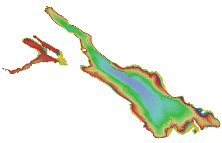
Die abgeleitete Darstellung von swissBATHY3D ermöglicht Visualisierungen des Reliefs und der Tiefe von Schweizer Seen. Die Reliefschattierung ist ein digitales Schummerungsbild bei einem berechneten Lichteinfall von Azimuth 315° (Nord-West) und einem Winkel von 45°.
Représentation dérivée de swissBATHY3D qui permet de visualiser la profondeur et le relief du fond des lacs suisses. L'ombrage du relief représente l'illumination d'une surface pour une position donnée du soleil. L'estompage de relief de swissBATHY3D a été calculé avec la position solaire suivante : azimut 315° (nord-ouest), hauteur 45°.
Rappresentazione derivata da swissBATHY3D che permette di visualizzare la profondità e il rilievo sul fondo dei laghi svizzeri. L' ombreggiature del rilievo swissALTI3D rappresenta l'illuminazione di una superficie per una posizione data del sole. L' ombreggiature del rilievo swissBATHY3D è calcolata con la seguente posizione solare azimut 315° (nord-ovest), altezza 45°.
This representation is derived from the swissBATHY3D data and allows the visualization of the depth and lakebed relief of Swiss lakes. A hillshade is derived from the elevation model by calculating the exposure of the surface to sunlight at a certain angle. The calculated angle of the sun for the swissBATHY3D Hillshade is at azimuth 315° (northwest), at a vertical angle of 45°.
La represchentaziun deviada da swissBATHY3D pussibilitescha da visualisar il reliev e las profunditads da lais svizzers. La sumbriva dal reliev è in maletg digital sumbrivà cun ina incidenza da la glisch calculada a l'acimut 315° (nord-vest) ed ad in angul da 45°.
Simple
-
Autre titreAltri nomi o acronimiAlternate titleAlternate titleAlternativtitel
-
swissBATHY3D Reliefschattierung
swissBATHY3D Ombrage du relief
swissBATHY3D Ombreggiature del rilievo
swissBATHY3D Hillshade
swissBATHY3D Sumbriva dal reliev
-
Date (Création)Data (Creazione)Date (Creation)Date (Creation)Datum (Erstellung)
- 2018-08-01T00:00:00
-
IdentifiantIdentificatoreIdentifierIdentifierKennung
- ch.swisstopo.swissbathy3d-reliefschattierung
Point de contact
Punto di contatto
Point of contact
Point of contact
Ansprechpartner
-
Type de représentation spatialeTipo di rappresentazione spazialeSpatial representation typeSpatial representation typeRäumliche Darstellungsart
-
grilleRasterGridGridRaster, Gitter
Résolution spatiale
Risoluzione spaziale
Spatial resolution
Spatial resolution
Räumliche Auflösung
-
Distance de résolutionDistanza di risoluzioneSpatial resolutionSpatial resolutionDistanz
- 1 m
-
Catégorie de thèmeCategoria ISOTopic categoryTopic categoryThematik
-
-
C ÉlévationC AltitudineC ElevationC ElevationC Höhenangaben
-
Étendue
Estensione
Extent
Extent
Ausdehnung
Étendue
Estensione
Extent
Extent
Ausdehnung
-
DescriptionDescrizioneDescriptionDescriptionBeschreibung
-
swissBATHY3D
swissBATHY3D
swissBATHY3D
swissBATHY3D
swissBATHY3D
))

-
Fréquence de mise à jourFrequenza di aggiornamentoMaintenance and update frequencyMaintenance and update frequencyWartungsintervall
-
Comme nécessaireSecondo necessitàAs neededAs neededBei Bedarf
- GEMET
-
-
laser
laser (radiazione)
laser
-
système d'information géographique
sistema informativo geografico
geographic information system
-
altitude
altitudine
altitude
-
modèle terrestre numérique
modello digitale del territorio
digital land model
-
relief
rilievo
relief (land)
-
- geocat.ch
-
-
courbe des fonds des lacs
quota altimetrica dei laghi
contour in lakes
-
opendata.swiss
opendata.swiss
opendata.swiss
opendata.swiss
-
modèle numérique de terrain MNT
modello digitale del terreno DTM
digital terrain model DTM
-
Airborne-Laser-Scanning
Airborne-Laser-Scanning
Airborne-Laser-Scanning
-
- GEMET - INSPIRE themes, version 1.0
-
-
Altitude
Elevazione
Elevation
-
- geocat.ch
-
-
IFDG l’Infrastructure Fédérale de données géographiques
IFDG Infrastruttura federale dei dati geografici
FSDI Federal Spatial Data Infrastructure
-
Contraintes sur la ressource
Vincoli sulle risorse
Resource constraints
Resource constraints
Ressourcenbeschränkungen
-
Contraintes d'utilisationVincoli d'usoUse constraintsUse constraintsNutzungseinschränkungen
-
Autres restrictionsAltre restrizioniOther restrictionsOther restrictionsAndere Beschränkungen
-
Autres contraintesAltri vincoliOther constraintsOther constraintsAndere Einschränkungen
-
Freie Nutzung. Quellenangabe ist Pflicht.
Utilisation libre. Obligation d’indiquer la source.
Libero utilizzo. Indicazione della fonte obbligatoria.
NonCommercialAllowed-CommercialAllowed-ReferenceRequired
Ressource associée
Risorsa associata
Associated resource
Associated resource
Verlinkte Ressource
-
TitreTitoloTitleTitleTitel
-
Höhendaten (Landesvermessung)
Données altimétriques (mensuration nationale)
Dati altimetrici (misurazione nazionale)
-
Type d'associationTipo di associazioneAssociation TypeAssociation TypeAssoziationstyp
-
Citation de travail plus largeCitazione di un'opera più ampiaReference to a master resource of which this one is a partReference to a master resource of which this one is a partÜbergeordneter Datenbestand
-
LangueLinguaLanguageLanguageSprache
- Deutsch
-
Encodage de caractèresCodifica dei caratteriCharacter encodingCharacter encodingZeichenkodierung
-
Utf8UTF8UTF8UTF8Utf8
-
LangueLinguaLanguageLanguageSprache
- English
-
Encodage de caractèresCodifica dei caratteriCharacter encodingCharacter encodingZeichenkodierung
-
Utf8UTF8UTF8UTF8Utf8
-
Géodonnées de baseGeodati di baseBasic GeodataBasic GeodataGeobasisdaten
- true
-
Identifiant Géodonnées de baseIdentificativo dei geodati di baseBasic Geodata IDBasic Geodata IDIdentifikator des Geobasisdatensatzes
-
41.6
-
Niveau des géodonnées de baseLivello legale dei geodati di baseBasic Geodata Legal LevelBasic Geodata Legal LevelGeobasisdatenebene
-
FédéralFederaleFederalFederalNational
-
Format de distributionFormato (codifica)Distribution formatDistribution formatAbgabeformat
-
-
GRID ASCII (XYZ)
-
ESRI ASCII Grid (.grd/.asc)
-
Options de transfert numérique
Opzioni di trasferimento digitale
Digital transfer options
Digital transfer options
Optionen für die digitale Übertragung
-
Ressource en ligneRisorsa onlineOnLine resourceOnLine resourceOnline
-
Vorschau map.geo.admin.ch
Vorschau map.geo.admin.chAperçu map.geo.admin.chPrevisione map.geo.admin.chPreview map.geo.admin.ch
Options de transfert numérique
Opzioni di trasferimento digitale
Digital transfer options
Digital transfer options
Optionen für die digitale Übertragung
-
Ressource en ligneRisorsa onlineOnLine resourceOnLine resourceOnline
-
ch.swisstopo.swissbathy3d-reliefschattierung
WMS-BGDI Dienst, Layer "swissBATHY3D Reliefschattierung"Service WMS-IFDG, couche "swissBATHY3D Ombrage du relief"Servizio WMS-IFDG, strato "swissBATHY3D Ombreggiature del rilievo"WMS-FSDI service, layer "swissBATHY3D Hillshade"WMS-BGDI Dienst, Layer "swissBATHY3D Reliefschattierung"
Options de transfert numérique
Opzioni di trasferimento digitale
Digital transfer options
Digital transfer options
Optionen für die digitale Übertragung
-
Ressource en ligneRisorsa onlineOnLine resourceOnLine resourceOnline
-
ch.swisstopo.swissbathy3d-reliefschattierung
WMTS-BGDI Dienst, Layer "swissBATHY3D Reliefschattierung"Service WMTS-IFDG, couche , Layer "swissBATHY3D Ombrage du relief"Servizio WMTS-IFDG, strato "swissBATHY3D Ombreggiature del rilievo"WMTS-FSDI service, layer "swissBATHY3D Hillshade"WMTS-BGDI Dienst, Layer "swissBATHY3D Reliefschattierung"
Options de transfert numérique
Opzioni di trasferimento digitale
Digital transfer options
Digital transfer options
Optionen für die digitale Übertragung
Options de transfert numérique
Opzioni di trasferimento digitale
Digital transfer options
Digital transfer options
Optionen für die digitale Übertragung
Options de transfert numérique
Opzioni di trasferimento digitale
Digital transfer options
Digital transfer options
Optionen für die digitale Übertragung
-
Nombre de dimensionsNumero di dimensioniNumber of dimensionsNumber of dimensionsAnzahl der Dimensionen
- 2
-
Géométrie de la celluleGeometria della cellaCell geometryCell geometryZellgeometrie
-
PointPuntoPointPointpoint
-
Disponibilité des paramètres de transformationDisponibilità dei parametri di trasformazioneTransformation parameter availabilityTransformation parameter availabilityVerfügbarkeit der Transformationsparameter
- 1
-
Nom du système de référenceNome del sistema di riferimentoReference system identifierReference system identifierName des Referenzsystems
- EPSG:2056
-
Nom du système de référenceNome del sistema di riferimentoReference system identifierReference system identifierName des Referenzsystems
- EPSG:5728
Metadata
-
Identifiant des métadonnéesIdentificativo della schedaMetadata identifierMetadata identifierIdentifikator des Metadatensatzes
- 81949e93-f552-42b6-ab4b-5a2d529a7768
-
LangueLinguaLanguageLanguageSprache
- Deutsch
-
Encodage de caractèresCodifica dei caratteriCharacter encodingCharacter encodingZeichenkodierung
-
Utf8UTF8UTF8UTF8Utf8
-
LangueLinguaLanguageLanguageSprache
- Français
-
Encodage de caractèresCodifica dei caratteriCharacter encodingCharacter encodingZeichenkodierung
-
Utf8UTF8UTF8UTF8Utf8
-
LangueLinguaLanguageLanguageSprache
- Italiano
-
Encodage de caractèresCodifica dei caratteriCharacter encodingCharacter encodingZeichenkodierung
-
Utf8UTF8UTF8UTF8Utf8
-
LangueLinguaLanguageLanguageSprache
- English
-
Encodage de caractèresCodifica dei caratteriCharacter encodingCharacter encodingZeichenkodierung
-
Utf8UTF8UTF8UTF8Utf8
-
LangueLinguaLanguageLanguageSprache
- Rumantsch
-
Encodage de caractèresCodifica dei caratteriCharacter encodingCharacter encodingZeichenkodierung
-
Utf8UTF8UTF8UTF8Utf8
Point de contact
Punto di contatto
Point of contact
Point of contact
Ansprechpartner
-
Heures de serviceOrario di servizioHours of serviceHours of serviceBetriebszeiten
-
08h30 - 11h00 / 14h00 - 16h00 GMT+1
Type de ressource
Tipo di risorsa
Type of resource
Type of resource
Anwendungsbereich der Metadaten
-
Domaine d'application de la ressourceAmbito di applicazione della risorsaResource scopeResource scopeDomäne der Ressourcenanwendung
-
Jeu de donnéesSet di datiDatasetDatasetDatenbestand
-
Lien vers la métadonnéeCollegamento ai metadatiMetadata linkageMetadata linkageLink zu den Metadaten
-
Informations de date (Création)Informazioni sulla data (Creazione)Date info (Creation)Date info (Creation)Datumsangaben (Erstellung)
- 2018-07-25T13:23:51Z
-
Informations de date (Révision)Informazioni sulla data (Revisione)Date info (Revision)Date info (Revision)Datumsangaben (Aktualisierung)
- 2026-05-27T10:14:03.709566Z
Norme des métadonnées
Standard dei metadati
Metadata standard
Metadata standard
Metadatenstandard
-
TitreTitoloTitleTitleTitel
-
eCH-0271