geocat.ch
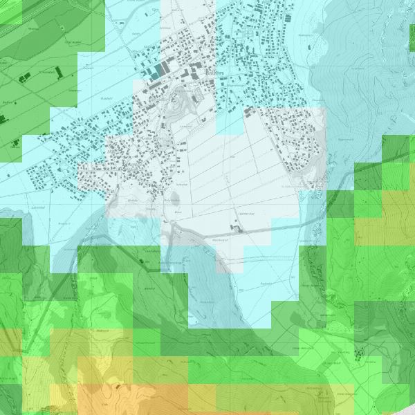
wind power map
The wind power map shows the calculated long-term average wind power at 50 metres above ground.
The value is defined as power per rotor area and W/m².
By clicking on the button in the toolbar above and on the corresponding area, you can also obtain the calculated values for heights of 10m, 100m, 150m and 200m.
The values shown for the average wind speed are based on modelling with certain uncertainties and only allow an initial assessment of the conditions.
Simple
- Alternate title
-
The wind power map shows the calculated long-term average wind power
- Date (Creation)
- 2013-11-13
- Identifier
- https://metadata.geo.llv.li/7e8e528a-b127-4bd8-ae27-0dee45567171
- Purpose
-
Wind utilisation
- Status
- Completed
Point of contact
- Hours of service
-
8:00-11:30 und 13:30-17:00
- Spatial representation type
- Vector
Spatial resolution
Equivalent scale
- Denominator
- 500
- Topic category
-
- Q Utilities communication
Extent
Extent
- Description
-
Liechtenstein
))

- Maintenance and update frequency
- As needed
- GEMET
-
-
resources
-
energy
-
energy source material
-
- geocat.ch
-
-
INSPIRE
-
- GEMET - INSPIRE themes, version 1.0
-
-
Energy resources
-
Resource constraints
- Access constraints
- Other restrictions
- Other constraints
- no limitations to public access
- Country
- LI
- Legislation Type
- Ordinance
- Legislation Level
- national
- Title
-
Verordnung vom 30. August 2011 über die Gebühren für die Nutzung der Geodateninfrastruktur Liechtenstein
- Date (Creation)
- 2011-08-30
Resource constraints
- Use limitation
-
Zugangs- und Nutzungsbedingungen
- Use constraints
- Other restrictions
- Other constraints
-
gebührenpflichtig
- Language
- Deutsch
- Character encoding
- UTF8
- Subtopic Category
- Q1 Energy
- Distribution format
-
-
ESRI Shapefile (SHP)
-
GeoTIFF (GEOTIFF)
-
Digital transfer options
- OnLine resource
-
Geodateportal der Landesverwaltung
Geodata Portal of the National Administration
- Hierarchy level
- Dataset
- Other
-
Alle Ebenen
Report
Result
- Title
-
COMMISSION REGULATION (EU) No 1089/2010 of 23 November 2010 implementing Directive 2007/2/EC of the European Parliament and of the Council as regards interoperability of spatial data sets and services
- Date (Publication)
- 2010-12-08
- Explanation
-
nicht geprüft
- Pass
- false
- Statement
-
Die ausgewiesenen Werte der mittleren Windgeschwindigkeit basieren auf einer Modellierung mit gewissen Unsicherheiten und erlauben nur eine erste Einschätzung der Verhältnisse.
- Hierarchy level
- Dataset
- Other
-
Alle Ebenen
- Topology level
- Full planar graph
- Geometric object type
- Surface
- Geometric object count
- 1
- Reference system identifier
- http://www.opengis.net/def/crs/EPSG/0/21782
- Reference system identifier
- http://www.opengis.net/def/crs/EPSG/0/4936
- Maintenance and update frequency
- As needed
Metadata
- Metadata identifier
- 7e8e528a-b127-4bd8-ae27-0dee45567171
- Language
- Deutsch
- Character encoding
- UTF8
- Language
- Français
- Character encoding
- UTF8
- Language
- Italiano
- Character encoding
- UTF8
- Language
- English
- Character encoding
- UTF8
Point of contact
- Hours of service
-
8:00-11:30 und 13:30-17:00
Type of resource
- Resource scope
- Dataset
- Metadata linkage
-
https://www.geocat.ch/geonetwork/srv/api/records/7e8e528a-b127-4bd8-ae27-0dee45567171
- Date info (Creation)
- 2021-04-21T13:20:02Z
- Date info (Revision)
- 2026-04-13T09:36:24.381568Z
Metadata standard
- Title
-
eCH-0271