geocat.ch
Terrestrische Aufnahmen swisstopo schwarzweiss
Prises de vue terrestres swisstopo noir et blanc
Riprese terrestri swisstopo bianco e nero
Terrestrial images swisstopo black and white
Fotografias terrestras swisstopo en alv e nair
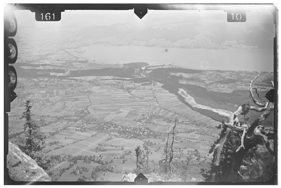
Die Bildsammlung von swisstopo umfasst rund 57'000 gescannte analoge schwarzweiss terrestrische Aufnahmen. Sie sind in Form der Bildzentrumskoordinaten, des jeweiligen abgedeckten Bodensegments (Footprint) sowie mit Metainformationen dargestellt. Diese Bilder können auch runtergeladen werden, genau wie die dazugehörigen Orientierungselemente, wenn es sie gibt.
La collection photographique de swisstopo comprend quelques 57'000 prises de vue terrestres en noir et blanc analogiques et scannées. Elles sont représentées sous la forme des coordonnées du centre de l'image, de la zone couverte par l'image (footprint) ainsi que par des métadonnées. Ces images peuvent également téléchargées tout comme les éléments d'orientation correspondant pour autant qu'ils existent.
La collezione fotografica di swisstopo comprende circa 57'000 riprese terrestri in bianco e nero analogiche e digitalizzate. Esse sono rappresentate sotto forma di coordinate del centro dell'immagine, delle zone da esse ricoperte (footprint), come pure dai loro metadati. Queste immagini possono anche essere scaricate, così come i relativi elementi di orientamento, se disponibili.
The imagery catalogue of swisstopo comprises around 57'000 scanned analogue black and white terrestrial images. They are represented by the centre-image coordinates, the image footprint as well as the attributed metadata. These images can also be downloaded, as can the corresponding orientation elements, where available.
La collecziun da fotografias da swisstopo cumpiglia circa 57'000 fotografias analogas terrestras alv e nairas ch'èn vegnidas scannadas. Ellas èn preschentadas en furma da las coordinatas dal center dal maletg, dal segment da terren respectiv (footprint) sco er cun meta-infurmaziuns. Questas maletgs pon er vegnir telechargiadas, uschia sco ils elements d’orientaziun respectivs, sch’els èn disponibels.
Simple
-
Autre titreAltri nomi o acronimiAlternate titleAlternate titleAlternativtitel
-
Terrestrische Aufnahmen swisstopo
Prises de vue terrestres swisstopo
Riprese terrestri swisstopo
Terrestrial images swisstopo
Fotografias terrestras swisstopo
-
Date (Création)Data (Creazione)Date (Creation)Date (Creation)Datum (Erstellung)
- 1927-01-01T00:00:00
-
IdentifiantIdentificatoreIdentifierIdentifierKennung
- ch.swisstopo.lubis-terrestrische_aufnahmen
-
ÉtatStatoStatusStatusBearbeitungsstatus
-
TerminéCompletatoCompletedCompletedAbgeschlossen
Propriétaire
Proprietario
Owner
Owner
Eigentümer
-
Catégorie de thèmeCategoria ISOTopic categoryTopic categoryThematik
-
-
A Imagerie, cartes de base et occupation du solA Mappe di base con immagini della copertura terrestreA Imagery base maps earth coverA Imagery base maps earth coverA Oberflächenbeschreibung
-
Étendue
Estensione
Extent
Extent
Ausdehnung
Étendue
Estensione
Extent
Extent
Ausdehnung
-
DescriptionDescrizioneDescriptionDescriptionBeschreibung
-
Switzerland
Schweiz
Suisse
Svizzera
Svizra
))

Étendue
Estensione
Extent
Extent
Ausdehnung
Étendue
Estensione
Extent
Extent
Ausdehnung
-
DescriptionDescrizioneDescriptionDescriptionBeschreibung
-
Liechtenstein
Liechtenstein
Liechtenstein
Liechtenstein
Liechtenstein
))

-
Fréquence de mise à jourFrequenza di aggiornamentoMaintenance and update frequencyMaintenance and update frequencyWartungsintervall
-
IrrégulièreIrregolareIrregularIrregularUnregelmässig
-
Durée de conservationDurata di conservazioneDuration of ConservationDuration of ConservationAufbewahrungsdauer NV in Jahren
- 275
-
Évaluation de la valeur archivistiqueValutazione del valore archivisticoAppraisal of Archival ValueAppraisal of Archival ValueBewertung Archivwürdigkeit
-
AAAAA
-
Raison de la valeur d'archivageMotivo del valore archivisticoReason for Archiving ValueReason for Archiving ValueBegründung Archivwürdigkeit
-
Preuve de la pratique couranteProva della pratica commercialeEvidence of business practiceEvidence of business practiceNachweis der Geschäftspraxis
- GEMET
-
-
photogrammétrie
fotogrammetria
photogrammetry
-
photographie
fotografia (procedimento)
photography
-
- geocat.ch
-
-
IFDG l’Infrastructure Fédérale de données géographiques
IFDG Infrastruttura federale dei dati geografici
FSDI Federal Spatial Data Infrastructure
-
Planification de la conservation et de l'archivage AAP - Conféderation
Pianificazione della conservazione e dell’archiviazione AAP - Confederazione
Conservation and archiving planning AAP - Confederation
-
Contraintes sur la ressource
Vincoli sulle risorse
Resource constraints
Resource constraints
Ressourcenbeschränkungen
-
Autres contraintesAltri vincoliOther constraintsOther constraintsAndere Einschränkungen
- Opendata BY: Freie Nutzung. Quellenangabe ist Pflicht.Opendata BY: Utilisation libre. Obligation d’indiquer la source.Opendata BY: Libero utilizzo. Indicazione della fonte obbligatoria.Opendata BY: Open use. Must provide the source.
Ressource associée
Risorsa associata
Associated resource
Associated resource
Verlinkte Ressource
-
Type d'associationTipo di associazioneAssociation TypeAssociation TypeAssoziationstyp
-
Citation de travail plus largeCitazione di un'opera più ampiaReference to a master resource of which this one is a partReference to a master resource of which this one is a partÜbergeordneter Datenbestand
-
Metadata ReferenceRiferimento metadatiMetadata ReferenceMetadata ReferenceMetadatenreferenz
-
LangueLinguaLanguageLanguageSprache
- Deutsch
-
Encodage de caractèresCodifica dei caratteriCharacter encodingCharacter encodingZeichenkodierung
-
Utf8UTF8UTF8UTF8Utf8
-
Catégorie de sous-thèmeCategoria di sottotemaSubtopic CategorySubtopic CategoryThematische Unterkategorien
-
A2 Couverture du sol, utilisation du solA2 Copertura del suolo, uso del suoloA2 Land Cover, Land UseA2 Land Cover, Land UseA2 Bodenbedeckung, Bodennutzung
-
Catégorie de sous-thèmeCategoria di sottotemaSubtopic CategorySubtopic CategoryThematische Unterkategorien
-
A3 Images aériennes, satellitesA3 Immagini aeree e satellitariA3 Aerial and Satellite ImageryA3 Aerial and Satellite ImageryA3 Luft-, Satellitenbilder
-
Géodonnées de baseGeodati di baseBasic GeodataBasic GeodataGeobasisdaten
- true
-
Identifiant Géodonnées de baseIdentificativo dei geodati di baseBasic Geodata IDBasic Geodata IDIdentifikator des Geobasisdatensatzes
-
36.1
-
Niveau des géodonnées de baseLivello legale dei geodati di baseBasic Geodata Legal LevelBasic Geodata Legal LevelGeobasisdatenebene
-
FédéralFederaleFederalFederalNational
-
Format de distributionFormato (codifica)Distribution formatDistribution formatAbgabeformat
-
-
Cloud Optimized GeoTIFF (TIFF / TIF)
-
Options de transfert numérique
Opzioni di trasferimento digitale
Digital transfer options
Digital transfer options
Optionen für die digitale Übertragung
-
Ressource en ligneRisorsa onlineOnLine resourceOnLine resourceOnline
-
Vorschau map.geo.admin.ch
Vorschau map.geo.admin.chAperçu map.geo.admin.chPrevisione map.geo.admin.chPreview map.geo.admin.ch
Options de transfert numérique
Opzioni di trasferimento digitale
Digital transfer options
Digital transfer options
Optionen für die digitale Übertragung
-
Ressource en ligneRisorsa onlineOnLine resourceOnLine resourceOnline
-
ch.swisstopo.lubis-terrestrische_aufnahmen
WMS-BGDI Dienst, Layer "Terrestrische Aufnahmen swisstopo"Service WMS-IFDG, couche "Prises de vue terrestres swisstopo"Servizio WMS-IFDG, strato "Riprese terrestri swisstopo"WMS-FSDI service, layer "Terrestrial images swisstopo"WMS-BGDI Dienst, Layer "Terrestrische Aufnahmen swisstopo"
Options de transfert numérique
Opzioni di trasferimento digitale
Digital transfer options
Digital transfer options
Optionen für die digitale Übertragung
-
Ressource en ligneRisorsa onlineOnLine resourceOnLine resourceOnline
-
ch.swisstopo.lubis-terrestrische_aufnahmen
WMTS-BGDI Dienst, Layer "Terrestrische Aufnahmen swisstopo"Service WMTS-IFDG, couche , Layer "Prises de vue terrestres swisstopo"Servizio WMTS-IFDG, strato "Riprese terrestri swisstopo"WMTS-FSDI service, layer "Terrestrial images swisstopo"WMTS-BGDI Dienst, Layer "Terrestrische Aufnahmen swisstopo"
Options de transfert numérique
Opzioni di trasferimento digitale
Digital transfer options
Digital transfer options
Optionen für die digitale Übertragung
-
Ressource en ligneRisorsa onlineOnLine resourceOnLine resourceOnline
-
Webseite Terrestrische Aufnahmen
Options de transfert numérique
Opzioni di trasferimento digitale
Digital transfer options
Digital transfer options
Optionen für die digitale Übertragung
-
Ressource en ligneRisorsa onlineOnLine resourceOnLine resourceOnline
-
RESTful API von geo.admin.ch
RESTful API von geo.admin.chRESTful API de geo.admin.chRESTful API da geo.admin.chRESTful API from geo.admin.chRESTful API dad geo.admin.ch
Options de transfert numérique
Opzioni di trasferimento digitale
Digital transfer options
Digital transfer options
Optionen für die digitale Übertragung
-
Ressource en ligneRisorsa onlineOnLine resourceOnLine resourceOnline
-
Metadaten
Options de transfert numérique
Opzioni di trasferimento digitale
Digital transfer options
Digital transfer options
Optionen für die digitale Übertragung
-
Ressource en ligneRisorsa onlineOnLine resourceOnLine resourceOnline
-
LUBIS-Viewer
Options de transfert numérique
Opzioni di trasferimento digitale
Digital transfer options
Digital transfer options
Optionen für die digitale Übertragung
-
Ressource en ligneRisorsa onlineOnLine resourceOnLine resourceOnline
-
Link für Datenbezug
Metadata
-
Identifiant des métadonnéesIdentificativo della schedaMetadata identifierMetadata identifierIdentifikator des Metadatensatzes
- 7e0b1343-0d6c-4d3d-9c63-9ed49ca2c0a9
-
LangueLinguaLanguageLanguageSprache
- Deutsch
-
Encodage de caractèresCodifica dei caratteriCharacter encodingCharacter encodingZeichenkodierung
-
Utf8UTF8UTF8UTF8Utf8
-
LangueLinguaLanguageLanguageSprache
- Français
-
Encodage de caractèresCodifica dei caratteriCharacter encodingCharacter encodingZeichenkodierung
-
Utf8UTF8UTF8UTF8Utf8
-
LangueLinguaLanguageLanguageSprache
- Italiano
-
Encodage de caractèresCodifica dei caratteriCharacter encodingCharacter encodingZeichenkodierung
-
Utf8UTF8UTF8UTF8Utf8
-
LangueLinguaLanguageLanguageSprache
- English
-
Encodage de caractèresCodifica dei caratteriCharacter encodingCharacter encodingZeichenkodierung
-
Utf8UTF8UTF8UTF8Utf8
-
LangueLinguaLanguageLanguageSprache
- Rumantsch
-
Encodage de caractèresCodifica dei caratteriCharacter encodingCharacter encodingZeichenkodierung
-
Utf8UTF8UTF8UTF8Utf8
Point de contact
Punto di contatto
Point of contact
Point of contact
Ansprechpartner
-
Heures de serviceOrario di servizioHours of serviceHours of serviceBetriebszeiten
-
08h30 - 11h00 / 14h00 - 16h00 GMT+1
Type de ressource
Tipo di risorsa
Type of resource
Type of resource
Anwendungsbereich der Metadaten
-
Domaine d'application de la ressourceAmbito di applicazione della risorsaResource scopeResource scopeDomäne der Ressourcenanwendung
-
Jeu de donnéesSet di datiDatasetDatasetDatenbestand
-
Lien vers la métadonnéeCollegamento ai metadatiMetadata linkageMetadata linkageLink zu den Metadaten
-
Informations de date (Création)Informazioni sulla data (Creazione)Date info (Creation)Date info (Creation)Datumsangaben (Erstellung)
- 2018-01-29T10:12:40Z
-
Informations de date (Révision)Informazioni sulla data (Revisione)Date info (Revision)Date info (Revision)Datumsangaben (Aktualisierung)
- 2026-04-13T09:25:06.921907Z
Norme des métadonnées
Standard dei metadati
Metadata standard
Metadata standard
Metadatenstandard
-
TitreTitoloTitleTitleTitel
-
eCH-0271