 geocat.ch
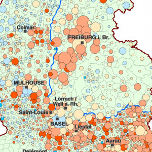
Change in the population aged 60 to 75 between 1999 and 2006 by Upper Rhine municipality
This map shows the evolution of the population aged 60 to 75 between 1999 and 2006 in the Upper Rhine area.
Simple
- Date (Creation)
- 2010-11-01
- Date (Publication)
- 2010-11-01
- Identifier
- 05_2010_0101
- Status
- Completed
Point of contact
- mri:deliveryPoint
-
100, avenue d'Alsace
- mri:city
-
COLMAR
- mri:postalCode
-
68000
- Country
-
FRANCE
- mri:electronicMailAddress
-
GeoRhena
Spatial resolution
Equivalent scale
- Denominator
- 100000
- Topic category
-
- M Society
Extent
Extent
Temporal extent
- Time period
- 1999-01-01 2006-12-31
Extent
Extent
N
S
E
W
))
- Maintenance and update frequency
- Not planned
- Keywords
-
-
Map
-
- Keywords
-
-
Upper Rhine
-
- GEMET - Concepts, version 2.4
-
-
demography
-
inhabitant
-
Resource constraints
- Use limitation
-
Licence CC BY
Resource constraints
- Access constraints
- Other restrictions
- Use constraints
- Other restrictions
- Other constraints
-
No other limitation
- Language
- Français
- Character encoding
- UTF8
- Distribution format
-
-
PDF Map
-
Digital transfer options
- OnLine resource
-
Pdf Download
Metadata
- Metadata identifier
- 787c48bc-b712-4c05-99dd-c5212a1e2cf8
- Language
- Français
- Character encoding
- UTF8
- Language
- Deutsch
- Character encoding
- UTF8
- Language
- English
- Character encoding
- UTF8
Contact
- mdb:deliveryPoint
-
100, avenue d'Alsace
- mdb:city
-
COLMAR
- mdb:postalCode
-
68000
- mdb:country
-
FR
Type of resource
- Resource scope
- staticMap
- Name
-
Carte statique
- Date info (Revision)
- 2022-10-20T08:20:57.834819Z
Metadata standard
- Title
-
ISO 19115-3:2018
- Edition
-
1.0
)))