geocat.ch
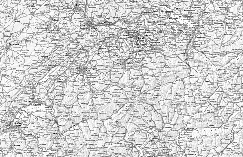
National maps of Switzerland (grey)
swisstopo produces national maps in the scales 1:10'000 up to 1:1 Million. The layer National maps (grey) combines the different maps and shows the best fitted map for each zoom level. The layer National maps (grey) is used as base map in the swiss federal geoportal. It is also available as WMS and WMTS geoservices. Once a year, a copy of the WMTS tile pyramid is made available for download in JPEG format and in the Web Mercator coordinate system (EPSG:3857) up to zoom level/tile matrix 18 (0.5 m resolution).
Simple
- Alternate title
-
National Maps (grey)
- Date (Creation)
- 2010-01-01
- Identifier
- ch.swisstopo.pixelkarte-grau
- Presentation form
- Digital map
- Purpose
-
Georeferenzdaten des Bundesrechts
- Status
- On going
Point of contact
Owner
- Spatial representation type
- Grid
Spatial resolution
Equivalent scale
- Denominator
- 10000
- Topic category
-
- A Imagery base maps earth cover
Extent
Extent
- Description
-
Switzerland
))

Extent
Extent
- Description
-
Liechtenstein
))

- Maintenance and update frequency
- Unknown
Resource format
- Title
-
Tagged Image File Format (TIFF)
- Date
- GEMET themes
-
-
geography
-
- GEMET
-
-
cartography
-
vegetation
-
water (geographic)
-
relief (land)
-
border
-
- geocat.ch
-
-
national map
-
terrain representation
-
traffic network
-
- GEMET - INSPIRE themes, version 1.0
-
-
Hydrography
-
Buildings
-
Elevation
-
Transport networks
-
Land cover
-
Orthoimagery
-
- geocat.ch
-
-
FSDI Federal Spatial Data Infrastructure
-
- geocat.ch
-
-
topography
-
- GEMET
-
-
map chart
-
Associated resource
- Title
-
National Maps 1:10'000 - 1:1 mio.
- Association Type
- Reference to a master resource of which this one is a part
- Language
- Deutsch
- Character encoding
- UTF8
- Language
- Français
- Character encoding
- UTF8
- Language
- Italiano
- Character encoding
- UTF8
- Language
- Rumantsch
- Character encoding
- UTF8
- Subtopic Category
- A1 Base Maps, Landscape Models
- Basic Geodata
- true
- Basic Geodata ID
-
42
- Basic Geodata Legal Level
- Federal
- Basic Geodata Type
- Reference Geodata
- Distribution format
-
-
JPEG (JPG)
-
Point of contact
Digital transfer options
- OnLine resource
-
Vorschau map.geo.admin.ch
Preview map.geo.admin.ch
Digital transfer options
- OnLine resource
-
ch.swisstopo.pixelkarte-grau
WMS-FSDI service, layer "National Maps (grey)"
Digital transfer options
- OnLine resource
-
ch.swisstopo.pixelkarte-grau
WMTS-FSDI service, layer "National Maps (grey)"
Digital transfer options
- OnLine resource
-
STAC Browser
The uncompressed tar archive contains the WebMercator (EPSG:3857) WMTS pyramid up to a resolution of 0.5 m or zoom level/tile matrix 18.
Digital transfer options
- OnLine resource
-
Produktinformation Swiss Map Raster
- Reference system identifier
- CH1903+
Metadata
- Metadata identifier
- 74aef814-0c97-4261-a2c1-df4a948aca8e
- Language
- Deutsch
- Character encoding
- UTF8
- Language
- Français
- Character encoding
- UTF8
- Language
- Italiano
- Character encoding
- UTF8
- Language
- English
- Character encoding
- UTF8
- Language
- Rumantsch
- Character encoding
- UTF8
Point of contact
Type of resource
- Resource scope
- Dataset
- Metadata linkage
-
https://www.geocat.ch/geonetwork/srv/api/records/74aef814-0c97-4261-a2c1-df4a948aca8e
- Date info (Creation)
- 2016-05-13T15:59:44Z
- Date info (Revision)
- 2026-04-13T09:25:57.270452Z
Metadata standard
- Title
-
eCH-0271