geocat.ch
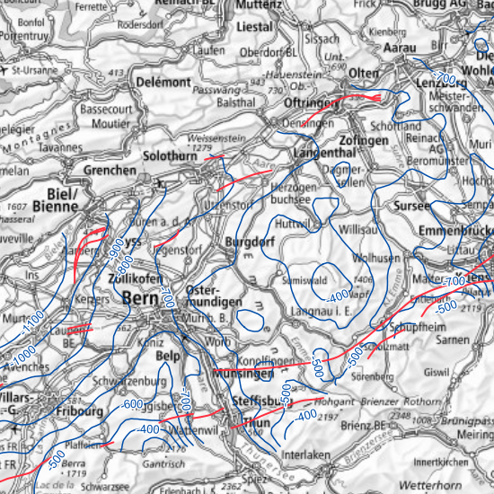
Temperaturmodell des Untergrundes des Schweizer Mittellandes - Höhe der 60 °C-Isotherme
Modèle de température souterraine du Plateau suisse - altitude de l'isotherme 60 °C
Modello di temperatura del sottosuolo dell'altopiano svizzero - elevazione dell'isoterma 60 °C
Subsurface temperature model of the Swiss Plateau - elevation of the 60 °C isotherm
Model da temperatura dal sutterren da la Bassa - nivel da l'isoterma da 60 °C
Ein wichtiger Parameter für die Beurteilung des geothermischen Potenzials des Schweizer Molassebeckens ist die Temperaturverteilung unter der Erdoberfläche.
Diese Karte zeigt die Höhenlinien der 60 °C-Isotherme und die Störungen auf der gleichen Höhenlage.
Diese gehört zu einer Serie, die die Temperaturverteilung auf ausgewählten Oberflächen zeigt (repräsentierend seismische Markerhorizonte, konstante Tiefen unter der Erdoberfläche oder Isothermen). Die Horizontoberflächen stammen aus dem geologischen 3D-Modell GeoMol15 und dem darauf basierenden GeoMol15-Temperaturmodell, das aus regelmässigen Zellen mit einer Grösse von 1000x1000x100 m besteht. Dieses Temperaturblockmodell ist abgeleitet von einem FE-Methode-Temperaturmodell (Geowatt AG, 2015), das vor allem auf 31 vertikalen Temperaturprofilen und den Horizontoberflächen des <a href=" https://www.geologieportal.ch/de/themen/grundlagen-der-geologie/geophysik/seismischer-atlas.html" target="_blank">Seismischen Atlas des Schweizerischen Molassebeckens (2012)</a> basiert. Die FE-Temperaturmodellierungsmethode nimmt nur den konduktiven Wärmestrom an und berücksichtigt den konvektiven Wärmestrom nicht. Das Modell GeoMol15 und das zugehörige Temperaturmodell stehen zur Online-Ansicht über den <a href=" https://viewer.geomol.ch/webgui/gui2.php" target="_blank">GeoMol-Viewer</a> zur Verfügung. Siehe auch die zugehörige Karte «<a href="https://map.geo.admin.ch/?layers=ch.swisstopo.geologie-geomol-temperaturmodell_eingangsdaten&topic=geol" target="_blank">Temperaturmodell - Daten</a>» auf map.geo.admin.ch .
L'un des principaux paramètres utilisé pour évaluer le potentiel géothermique du bassin molassique suisse est la répartition de la température sous la surface.
Cette carte montre les courbes de niveau des altitudes de l’isotherme 60 °C et les failles à la même altitude.
Elle fait partie d'un ensemble de cartes montrant la répartition de la température sur des surfaces sélectionnées représentant des horizons marqueurs sismiques, des profondeurs fixes sous le niveau du sol ou des isothermes. Les surfaces des horizons géologiques sont extraites du modèle 3D GeoMol15 et les températures du modèle de température GeoMol15, composé de cellules régulières de taille 1000x1000x100 m. Ce modèle de température (en blocs) est dérivé du modèle de température en éléments finis (Geowatt AG, 2015), qui repose principalement sur 31 profils verticale de température et les horizons géologiques de <a href=" https://www.geologieportal.ch/fr/themes/bases-de-la-geologie/geophysique/atlas-sismique.html" target="_blank">l’Atlas sismique du bassin molassique suisse (2012)</a>. La méthode de modélisation de la température en éléments finis se base uniquement sur un flux de chaleur par conduction et ne prend pas en compte de flux de chaleur par convection. Le modèle 3D GeoMol15 ainsi que le modèle de température associé sont disponibles pour une visualisation en ligne avec le <a href=" https://viewer.geomol.ch/webgui/gui2.php" target="_blank">visualisateur GeoMol</a>. Veuillez également consulter la carte associée «<a href="https://map.geo.admin.ch/?layers=ch.swisstopo.geologie-geomol-temperaturmodell_eingangsdaten&topic=geol" target="_blank">Modèle de température - Données</a>» sur map.geo.admin.ch .
Uno dei parametri principali utilizzati per valutare il potenziale geotermico del bacino molassico svizzero è la distribuzione della temperatura del sottosuolo.
Questo dataset mostra le curve di livello dell’isoterma 60 °C e le faglie alle rispettive elevazioni.
Questo fa parte di un insieme di geodati che mostrano la distribuzione della temperatura su superfici selezionate come orizzonti marcatori sismici, profondità fisse o isoterme. Gli orizzonti geologici sono tratti dal modello geologico 3D GeoMol15 e le temperature dal modello di temperatura GeoMol15, composto da celle di taglia 1000 x 1000 x 100 metri. Quest’ultimo è derivato dal modello di temperatura del metodo FE (Geowatt AG, 2015), che si basa principalmente su 31 profili verticali di temperatura e sulle superfici orizzontali <a href=" https://www.geologieportal.ch/it/temi/nozioni-di-base-sulla-geologia/Geofisica/atlante-sismico.html" target="_blank">dell'Atlante sismico del bacino molassico svizzero (2012)</a>. Il metodo di modellamento della temperatura FE (elementi finiti) considera solo il flusso termico conduttivo e non il flusso convettivo. Il modello GeoMol15 e il relativo modello di temperatura sono disponibili online tramite il <a href=" https://viewer.geomol.ch/webgui/gui2.php" target="_blank">GeoMol Viewer</a>. Si prega di consultare anche il dataset associato «<a href="https://map.geo.admin.ch/?layers=ch.swisstopo.geologie-geomol-temperaturmodell_eingangsdaten&topic=geol" target="_blank">Modello di temperatura - Dati</a>» su map.geo.admin.ch .
One of the main parameters used in assessing the geothermal potential of the Swiss Molasse Basin is the subsurface distribution of temperature.
This map shows the elevation contours of the 60 °C isotherm and the faults at the same elevation.
It is one of a set of maps that shows the distribution of temperature on selected surfaces representing seismic marker horizons, fixed depths below ground level or isotherms. The horizon surfaces are taken from the GeoMol15 geological 3D model and the temperatures from the GeoMol15 temperature model, which is composed of regular cells that are 1000x1000x100 m in size. This temperature block model is derived from a FE-method temperature model (Geowatt AG, 2015), which is based primarily on 31 vertical temperature profiles and the horizon surfaces from the <a href=" https://www.geologieportal.ch/en/themes/fundamentals-of-geology/geophysics/seismic-atlas.html" target="_blank">Seismic Atlas of the Swiss Molasse Basin (2012)</a>. The FE temperature modelling method assumes conductive heat flow only and does not consider convective heat flow. The GeoMol15 and associated temperature model are available for online viewing with the <a href=" https://viewer.geomol.ch/webgui/gui2.php" target="_blank">GeoMol Viewer</a>. Please also see the associated «<a href="https://map.geo.admin.ch/?layers=ch.swisstopo.geologie-geomol-temperaturmodell_eingangsdaten&topic=geol" target="_blank">Temperature Model - Data</a>» map on map.geo.admin.ch .
In parameter impurtant per giuditgar il potenzial geotermic dal batschigl da molassa svizzer è la distribuziun da la temperatura el sutterren.
Questa charta mussa las lingias d'autezza da las isotermas da 60°C ed las ruttadiras sin il medem nivel.
Ella fa part d'ina seria da chartas che mussan la distribuziun da la temperatura sin surfatschas selecziunadas (represchentond orizonts marcaders seismics, profunditads constantas sut la surfatscha da la terra u isotermas). Las surfatschas d'orizont derivan dal model 3D geologic GeoMol15 e dal model da temperatura GeoMol15 che sa basa sin tal e che consista da cellas regularas d'ina grondezza da 1000x1000x100m. Quest model da temperatura en blocs è deducì d'in model da temperatura da la metoda FE (Geowatt AG, 2015) che sa basa oravant tut sin 31 profils da temperatura verticals e sin las surfatschas d'orizont da l'<a href=" https://www.geologieportal.ch/de/themen/grundlagen-der-geologie/geophysik/seismischer-atlas.html" target="_blank">Atlas seismic dal batschigl da molassa svizzer (2012)</a>. La metoda da modellament da las temperaturas FE (elements finits) lavura mo cun il fluss da chalur conductiv. Ella na resguarda betg il fluss da chalur convectiv. Il model GeoMol15 ed il model da temperatura appartegnent stattan a disposiziun online sut <a href=" https://viewer.geomol.ch/webgui/gui2.php" target="_blank">GeoMol-Viewer</a>. Guardar er la charta appartegnenta «<a href="https://map.geo.admin.ch/?layers=ch.swisstopo.geologie-geomol-temperaturmodell_eingangsdaten" target="_blank">Model da temperatur - datas</a>» sin map.geo.admin.ch .
Simple
-
Autre titreAltri nomi o acronimiAlternate titleAlternate titleAlternativtitel
-
Höhe 60 °C-Isotherme
Altitude isotherme 60 °C
Elevazione isotherma 60 °C
Elevation 60 °C isotherm
Nivel isoterma 60 °C
-
Date (Création)Data (Creazione)Date (Creation)Date (Creation)Datum (Erstellung)
- 2018-12-24
-
Date (Révision)Data (Revisione)Date (Revision)Date (Revision)Datum (Aktualisierung)
- 2020-12-03
-
IdentifiantIdentificatoreIdentifierIdentifierKennung
- ch.swisstopo.geologie-geomol-isotherme_60
-
ÉtatStatoStatusStatusBearbeitungsstatus
-
TerminéCompletatoCompletedCompletedAbgeschlossen
Propriétaire
Proprietario
Owner
Owner
Eigentümer
-
Type de représentation spatialeTipo di rappresentazione spazialeSpatial representation typeSpatial representation typeRäumliche Darstellungsart
-
vecteurVettorialeVectorVectorVektor
-
Catégorie de thèmeCategoria ISOTopic categoryTopic categoryThematik
-
-
F Informations géoscientifiquesF Informazioni geoscientificheF Geoscientific informationF Geoscientific informationF Erdwissenschaften
-
Étendue
Estensione
Extent
Extent
Ausdehnung
Étendue
Estensione
Extent
Extent
Ausdehnung
-
DescriptionDescrizioneDescriptionDescriptionBeschreibung
-
GeoMol15 temperature model limit
GeoMol15-Temperaturmodellgrenze
Limite du modèle de température GeoMol15
Limite del modello di temperatura GeoMol15
-
Identifiant géographiqueIdentificatore geograficoGeographic identifierGeographic identifierGeografische Kennung
- --
))

-
Fréquence de mise à jourFrequenza di aggiornamentoMaintenance and update frequencyMaintenance and update frequencyWartungsintervall
-
Comme nécessaireSecondo necessitàAs neededAs neededBei Bedarf
- GEMET
-
-
source d'énergie renouvelable
fonte di energia rinnovabile
renewable energy source
-
température
temperatura
temperature
-
énergie géothermique
energia geotermica
geothermal energy
-
énergie
energia
energy
-
ressource énergétique
risorse energetiche
energy resource
-
sous-sol
sottosuolo
subsoil
-
- geocat.ch
-
-
opendata.swiss
opendata.swiss
opendata.swiss
opendata.swiss
-
géothermie
geotermia
geothermal energy
-
confédération
confederazione
confederation
-
IFDG l’Infrastructure Fédérale de données géographiques
IFDG Infrastruttura federale dei dati geografici
FSDI Federal Spatial Data Infrastructure
-
EGDI (European Geological Data Infrastructure)
EGDI (European Geological Data Infrastructure)
EGDI (European Geological Data Infrastructure)
-
- GEMET - INSPIRE themes, version 1.0
-
-
Sources d'énergie
Risorse energetiche
Energy resources
-
Contraintes sur la ressource
Vincoli sulle risorse
Resource constraints
Resource constraints
Ressourcenbeschränkungen
-
Contraintes d'utilisationVincoli d'usoUse constraintsUse constraintsNutzungseinschränkungen
-
Autres restrictionsAltre restrizioniOther restrictionsOther restrictionsAndere Beschränkungen
-
Autres contraintesAltri vincoliOther constraintsOther constraintsAndere Einschränkungen
- Opendata BY: Freie Nutzung. Quellenangabe ist Pflicht.Opendata BY: Utilisation libre. Obligation d’indiquer la source.Opendata BY: Libero utilizzo. Indicazione della fonte obbligatoria.Opendata BY: Open use. Must provide the source.
Ressource associée
Risorsa associata
Associated resource
Associated resource
Verlinkte Ressource
-
Type d'associationTipo di associazioneAssociation TypeAssociation TypeAssoziationstyp
-
Citation de travail plus largeCitazione di un'opera più ampiaReference to a master resource of which this one is a partReference to a master resource of which this one is a partÜbergeordneter Datenbestand
-
Metadata ReferenceRiferimento metadatiMetadata ReferenceMetadata ReferenceMetadatenreferenz
-
LangueLinguaLanguageLanguageSprache
- Deutsch
-
Encodage de caractèresCodifica dei caratteriCharacter encodingCharacter encodingZeichenkodierung
-
Utf8UTF8UTF8UTF8Utf8
-
LangueLinguaLanguageLanguageSprache
- Français
-
Encodage de caractèresCodifica dei caratteriCharacter encodingCharacter encodingZeichenkodierung
-
Utf8UTF8UTF8UTF8Utf8
-
LangueLinguaLanguageLanguageSprache
- Italiano
-
Encodage de caractèresCodifica dei caratteriCharacter encodingCharacter encodingZeichenkodierung
-
Utf8UTF8UTF8UTF8Utf8
-
LangueLinguaLanguageLanguageSprache
- English
-
Encodage de caractèresCodifica dei caratteriCharacter encodingCharacter encodingZeichenkodierung
-
Utf8UTF8UTF8UTF8Utf8
-
Catégorie de sous-thèmeCategoria di sottotemaSubtopic CategorySubtopic CategoryThematische Unterkategorien
-
F1 GéologieF1 GeologiaF1 GeologyF1 GeologyF1 Geologie
-
Catégorie de sous-thèmeCategoria di sottotemaSubtopic CategorySubtopic CategoryThematische Unterkategorien
-
Q1 ÉnergieQ1 EnergiaQ1 EnergyQ1 EnergyQ1 Energie
-
Format de distributionFormato (codifica)Distribution formatDistribution formatAbgabeformat
-
-
ESRI File Geodatabase FileGDB (GDB)
-
Options de transfert numérique
Opzioni di trasferimento digitale
Digital transfer options
Digital transfer options
Optionen für die digitale Übertragung
-
Ressource en ligneRisorsa onlineOnLine resourceOnLine resourceOnline
-
Vorschau map.geo.admin.ch
Vorschau map.geo.admin.chAperçu map.geo.admin.chPrevisione map.geo.admin.chPreview map.geo.admin.ch
Options de transfert numérique
Opzioni di trasferimento digitale
Digital transfer options
Digital transfer options
Optionen für die digitale Übertragung
-
Ressource en ligneRisorsa onlineOnLine resourceOnLine resourceOnline
-
ch.swisstopo.geologie-geomol-isotherme_60
WMS-BGDI Dienst, Layer "Höhe 60 °C-Isotherme"Service WMS-IFDG, couche "Altitude isotherme 60 °C"Servizio WMS-IFDG, strato "Elevazione isotherma 60 °C"WMS-FSDI service, layer "Elevation 60 °C isotherm"WMS-BGDI Dienst, Layer "Höhe 60 °C-Isotherme"
Options de transfert numérique
Opzioni di trasferimento digitale
Digital transfer options
Digital transfer options
Optionen für die digitale Übertragung
-
Ressource en ligneRisorsa onlineOnLine resourceOnLine resourceOnline
-
RESTful API von geo.admin.ch
Options de transfert numérique
Opzioni di trasferimento digitale
Digital transfer options
Digital transfer options
Optionen für die digitale Übertragung
-
Ressource en ligneRisorsa onlineOnLine resourceOnLine resourceOnline
-
Download
Options de transfert numérique
Opzioni di trasferimento digitale
Digital transfer options
Digital transfer options
Optionen für die digitale Übertragung
-
Ressource en ligneRisorsa onlineOnLine resourceOnLine resourceOnline
-
viewer.swissgeol.ch
-
Ressource en ligneRisorsa onlineOnLine resourceOnLine resourceOnline
-
GeoMol-Viewer
Identifiant
Identificativo
Identifier
Identifier
Identifikator
-
CodeCodiceCodeCodeCode
- EPSG:2056
-
DescriptionDescrizioneDescriptionDescriptionBeschreibung
-
CH1903+ / LV95 (EPSG:2056)
Metadata
-
Identifiant des métadonnéesIdentificativo della schedaMetadata identifierMetadata identifierIdentifikator des Metadatensatzes
- 6edca35d-0f08-43b9-9faf-4c7b207888a1
-
LangueLinguaLanguageLanguageSprache
- Deutsch
-
Encodage de caractèresCodifica dei caratteriCharacter encodingCharacter encodingZeichenkodierung
-
Utf8UTF8UTF8UTF8Utf8
-
LangueLinguaLanguageLanguageSprache
- Français
-
Encodage de caractèresCodifica dei caratteriCharacter encodingCharacter encodingZeichenkodierung
-
Utf8UTF8UTF8UTF8Utf8
-
LangueLinguaLanguageLanguageSprache
- Italiano
-
Encodage de caractèresCodifica dei caratteriCharacter encodingCharacter encodingZeichenkodierung
-
Utf8UTF8UTF8UTF8Utf8
-
LangueLinguaLanguageLanguageSprache
- English
-
Encodage de caractèresCodifica dei caratteriCharacter encodingCharacter encodingZeichenkodierung
-
Utf8UTF8UTF8UTF8Utf8
-
LangueLinguaLanguageLanguageSprache
- Rumantsch
-
Encodage de caractèresCodifica dei caratteriCharacter encodingCharacter encodingZeichenkodierung
-
Utf8UTF8UTF8UTF8Utf8
Propriétaire
Proprietario
Owner
Owner
Eigentümer
Type de ressource
Tipo di risorsa
Type of resource
Type of resource
Anwendungsbereich der Metadaten
-
Domaine d'application de la ressourceAmbito di applicazione della risorsaResource scopeResource scopeDomäne der Ressourcenanwendung
-
Jeu de donnéesSet di datiDatasetDatasetDatenbestand
-
Lien vers la métadonnéeCollegamento ai metadatiMetadata linkageMetadata linkageLink zu den Metadaten
-
Informations de date (Création)Informazioni sulla data (Creazione)Date info (Creation)Date info (Creation)Datumsangaben (Erstellung)
- 2019-01-29T14:50:01Z
-
Informations de date (Révision)Informazioni sulla data (Revisione)Date info (Revision)Date info (Revision)Datumsangaben (Aktualisierung)
- 2026-08-04T09:15:04.871159Z
Norme des métadonnées
Standard dei metadati
Metadata standard
Metadata standard
Metadatenstandard
-
TitreTitoloTitleTitleTitel
-
eCH-0271