geocat.ch
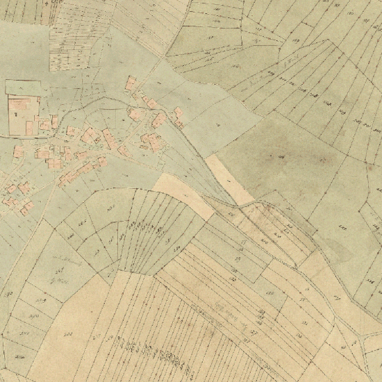
Katasterplan Bettingen 1827
Katasteraufnahme von Th. Wenk, Ausgeführt im Jahre 1827
Simple
- Date (Creation)
- 2014-11-04
- Status
- Completed
Owner
- Spatial representation type
- Grid
Spatial resolution
- Spatial resolution
- 0.25 m
- Topic category
-
- A Imagery base maps earth cover
Extent
Extent
- Description
-
Bettingen
))

- Maintenance and update frequency
- Not planned
- geocat.ch
-
-
historic map
-
- geocat.ch
-
-
opendata.swiss
-
Resource constraints
- Other constraints
-
Die Geodaten sind öffentlich zugänglich. (Zugangsberechtigungsstufe [A] = öffentlich)
- Other constraints
-
Es gelten die Nutzungsbedingungen für Geodaten des Kantons Basel-Stadt. ( http://www.geo.bs.ch/agb)
Associated resource
- Association Type
- Resource is a description of associated resource
- Metadata Reference
Associated resource
- Title
-
Historische Pläne
- Association Type
- Reference to a master resource of which this one is a part
- Language
- Deutsch
- Character encoding
- UTF8
- Subtopic Category
- A1 Base Maps, Landscape Models
- Basic Geodata
- false
- Basic Geodata Type
- openData
- Distribution format
-
-
INTERLIS 1 (ITF)
-
Digital transfer options
- OnLine resource
-
MapBS
Öffentliches Auskunftssystem des Kantons Basel-Stadt
Digital transfer options
- OnLine resource
-
WMS BS
Die derzeit im WMS BS verfügbaren Datenebenen entsprechen, bis auf wenige Ausnahmen, den Geodaten, welche auch in MapBS dargestellt sind. Der WMS BS ist kostenlos nutzbar und bietet Zugriff auf öffentliche sowie beschränkt öffentliche Geodaten, wobei gegebenenfalls Benutzername und Passwort benötigt werden (Zugangsdaten von MapBS).
Digital transfer options
- OnLine resource
-
WMTS BS
Im WMTS BS werden die in MapBS verfügbaren Hintergrundkarten angeboten. Der WMTS BS ist kostenlos nutzbar.
Digital transfer options
- OnLine resource
-
Permalink opendata.swiss
Permalink opendata.swiss
- Reference system identifier
- CH1903+ / LV95/EPSG: 2056
Metadata
- Metadata identifier
- 6e458fd5-011f-4da8-ba37-8cd337301d39
- Language
- Deutsch
- Character encoding
- UTF8
- Language
- Français
- Character encoding
- UTF8
- Language
- Italiano
- Character encoding
- UTF8
- Language
- English
- Character encoding
- UTF8
Custodian
Type of resource
- Resource scope
- Dataset
- Metadata linkage
-
https://www.geocat.ch/geonetwork/srv/api/records/6e458fd5-011f-4da8-ba37-8cd337301d39
- Date info (Creation)
- 2014-10-29T14:47:04Z
- Date info (Revision)
- 2026-04-13T09:39:02.020066Z
Metadata standard
- Title
-
eCH-0271