geocat.ch
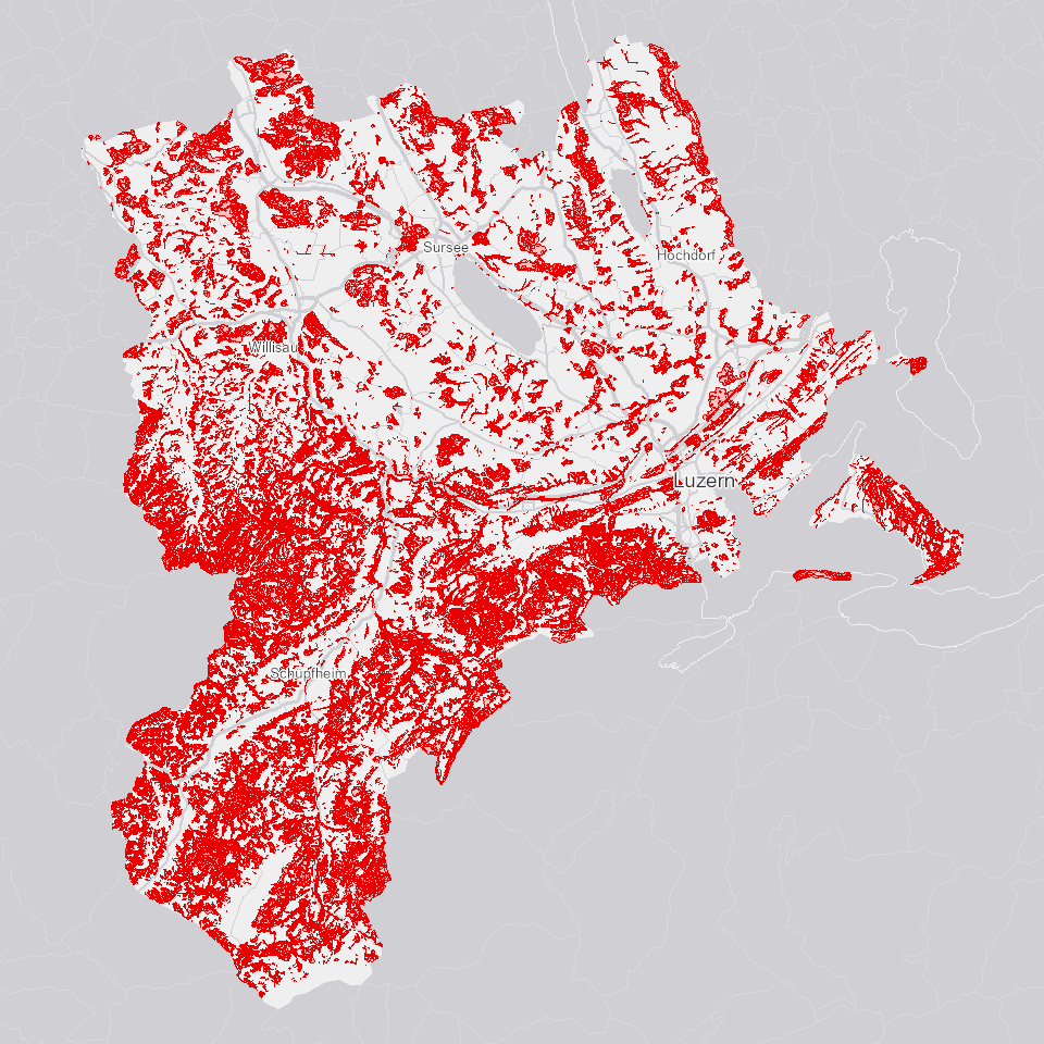
Standortstypen Wald
Standortstypen (Potenzial): Pflanzensoziologische Kartierung. Standorttypen werden durch floristische, standörtliche und strukturelle Merkmale charakterisiert, basiernd auf Standard NaiS-LFI.
Simple
Informazioni di identificazione
- Titolo alternativo
-
STAOTYWA_DS
- Data (Creazione)
- 2022-02-18
- Formato di presentazione
- Mappa digitale
- Finalità
-
Zeigt die Standortstypen Wald im Kt. Luzern (Pflanzensoziologie) gemäss dem Standard NaiS-LFI 2021.In der traditionellen Pflanzensoziologie werden die Pflanzengesellschaften rein floristisch definiert. Insbesondere im naturnahen Waldbau genügen diese Definitionen nicht. Deshalb wurde im Rahmen des NaiS-Projekts (NaiS für «Nachhaltigkeit im Schutzwald») das System Standortstypen entwickelt, das floristische, standörtliche und waldbauliche Merkmale verwendet. Mit dem System der NaiS-Standorttypen wurde ein in der ganzen Schweiz anwendbares, praxisorientiertes Hilfsmittel geschaffen, mit dem sich die vielfältigen Wälder des Landes standörtlich und waldbaubezogen beschreiben lassen.Auf Initiative des Bundesamts für Umwelt wurden im Projekt «NaiS-LFI: Zuordnung der LFI-Stichprobenpunkte zu Waldgesellschaften» von 2014 bis 2019 alle 6357 Probeflächen des vierten Landesforstinventars (LFI) einem aktualisierten NaiS-Standorttyp (Nachhaltigkeit und Erfolgskontrolle im Schutzwald) zugeordnet.
- Status
- In corso
Punto di contatto
Servizio responsabile
- Nome dell'ente
-
Kanton Luzern, Abteilung Geoinformation
- Telefono
-
041 228 51 83
Indirizzo
- Risorsa online
- https://geoportal.lu.ch/ ( https )
- Ruolo
- Publisher
Punto di contatto
Servizio responsabile
- Nome dell'ente
-
Dienststelle Landwirtschaft und Wald (lawa)
- Telefono
-
041 349 74 00
Indirizzo
- Ruolo
- Owner
- Cognome
-
Dienststelle Landwirtschaft und Wald (lawa)
- Abbreviazione dell'organizzazione
-
lawa
- Frequenza di aggiornamento
- Secondo necessità
-
geocat.ch
-
-
opendata.swiss
-
Biodiversität
-
Forstwirtschaft
-
Vegetation
-
Wald
-
- Vincoli di accesso
- none
- Vincoli di fruibilità
- Proprietà intellettuale dei dati
- Limitazione d’uso
-
öffentlich zugängliche Geobasisdaten
- Vincoli di accesso
- none
- Vincoli di fruibilità
- none
- Limitazione d’uso
-
Freie Nutzung. Quellenangabe ist Pflicht
- Identificatore aggregato del dataset
- 1fdc46fe-88d5-4db1-a971-3ecf1a4254b0
- Tipo di associazione
- Larger work citation
- Identificatore aggregato del dataset
- a0610b38-3a85-4f3a-a423-88d10b97e197
- Tipo di associazione
- Larger work citation
- Identificatore aggregato del dataset
- 9003e085-bf63-4544-9274-0a0c11b5fbc2
- Tipo di associazione
- Larger work citation
- Tipo di rappresentazione spaziale
- Dati vettoriali
- Lingua dei metadati
- Deutsch
- Set dei caratteri dei metadati
- UTF8
- Tema
-
- G Bosco, flora, fauna
- Descrizione
-
Kanton Luzern
))
- Formato di distribuzione
-
-
ESRI Geodatabase (.gdb)
(
)
-
ESRI Shapefile (.shp)
(
)
-
OGC GeoPackage (.gpkg)
(
)
-
ESRI Geodatabase (.gdb)
(
)
Distributore
Servizio responsabile
- Nome dell'ente
-
Dienststelle Raum und Wirtschaft (rawi)
- Telefono
-
041 228 51 83
Indirizzo
- Risorsa online
- https://geoportal.lu.ch ( https )
- Ruolo
- Point of contact
- Nome
-
Geodaten
- Cognome
-
Kanton Luzern
- Abbreviazione dell'organizzazione
-
rawi
- Risorsa online
-
Datenshop
(
https
)
Produktansicht Geodatenshop
- Livello
- Set di dati
- Genealogia del dato – Processo di produzione
-
unbekannt
- Oggetto di tipo geometrico
- polygon
- Identificatore del sistema di riferimento
- CH1903+
Informazioni sul contenuto
- Lingua dei metadati
-
ger
- Included with dataset
- Data (Pubblicazione)
- 2021-12-09
Classe
- Designazione
-
Flächen
Attributo
- Nome
-
OBJECTID
- Descrizione
-
OBJECTID
Attributo
- Nome
-
FARBE
- Descrizione
-
Farbe
Attributo
- Nome
-
HS
- Descrizione
-
Hoehenstufe
Attributo
- Nome
-
NAIS1
- Descrizione
-
NaiS
Attributo
- Nome
-
NAIS2
- Descrizione
-
NaiS Uebergang
Attributo
- Nome
-
PLOTTXT
- Descrizione
-
Bezeichnung
Attributo
- Nome
-
PRIO
- Descrizione
-
Prioritaet
Attributo
- Nome
-
STO1
- Descrizione
-
Hauptgesellschaft_cod
Attributo
- Nome
-
STO1_TXT
- Descrizione
-
Hauptgesellschaft
Attributo
- Nome
-
STO2
- Descrizione
-
Spezifikation_cod
Attributo
- Nome
-
STO2_TXT
- Descrizione
-
Spezifikation
Attributo
- Nome
-
STO3
- Descrizione
-
Subklasse_cod
Attributo
- Nome
-
STO3_TXT
- Descrizione
-
Subklasse
Attributo
- Nome
-
STO4
- Descrizione
-
Unterteilung_cod
Attributo
- Nome
-
STO4_TXT
- Descrizione
-
Unterteilung
Attributo
- Nome
-
STO5
- Descrizione
-
Unterteilung_2_cod
Attributo
- Nome
-
STO5_TXT
- Descrizione
-
Unterteilung_2
Attributo
- Nome
-
TYP
- Descrizione
-
Gesellschaftstyp
Attributo
- Nome
-
VERDRISK
- Descrizione
-
Verdichtungsrisiko
Attributo
- Nome
-
SHAPE
- Descrizione
-
Shape
Attributo
- Nome
-
SHAPE.AREA
- Descrizione
-
SHAPE.AREA
Attributo
- Nome
-
SHAPE.LEN
- Descrizione
-
SHAPE.LEN
- Genere del modello
- Descrizione di oggetto
Metadata
- Lingua dei metadati
- Deutsch
- Set dei caratteri dei metadati
- UTF8
- Livello gerarchico
- Set di dati
- Data dei metadati
- 2025-09-03
- Nome dello Standard dei metadati
-
GM03 2+
Contatto
Servizio responsabile
- Nome dell'ente
-
Dienststelle Raum und Wirtschaft (rawi)
- Telefono
-
041 228 51 83
Indirizzo
- Città
-
Luzern
- Codice postale
-
6002
- Nazione
-
CH
- Via
-
Murbacherstrasse
- Numero
-
21
- Risorsa online
- https://geoportal.lu.ch ( https )
- Ruolo
- Point of contact
- Nome
-
PhulbaDoma
- Cognome
-
Lama
- Abbreviazione dell'organizzazione
-
rawi
- Frequenza di aggiornamento
- Non pianificato