geocat.ch
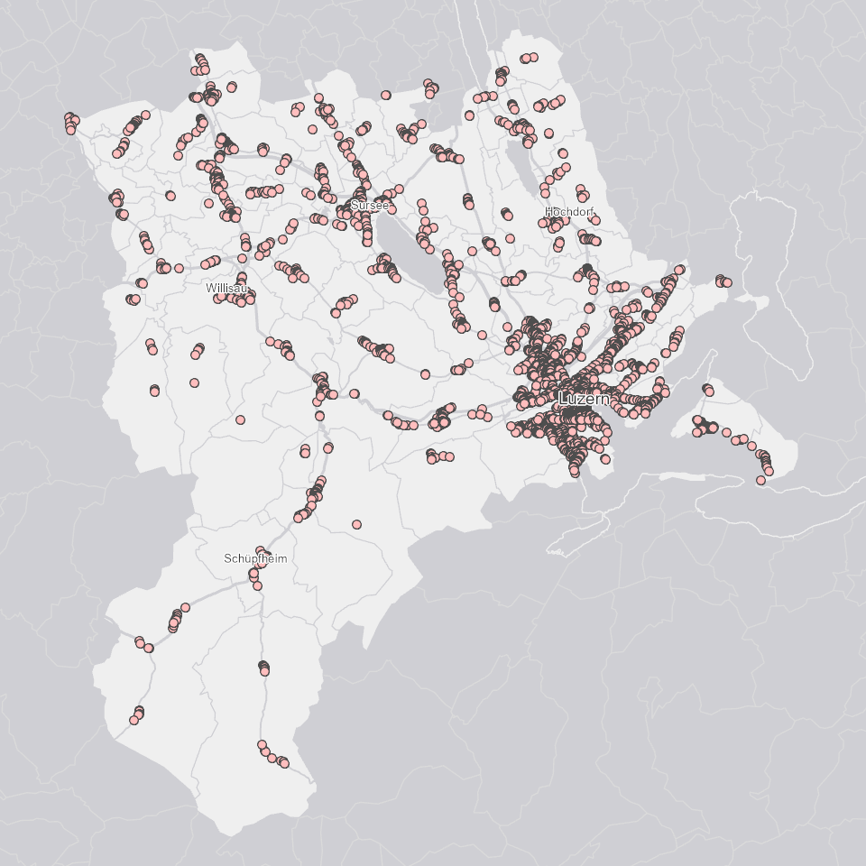
Fussgängerstreifen
Fussgängerstreifen detektiert aus dem aktuellen Luftbild (2020) mit Hilfe von DeepLearning.
Simple
Informazioni di identificazione
- Titolo alternativo
-
FUSSGSTR_DS
- Data (Creazione)
- 2023-05-08
- Formato di presentazione
- Mappa digitale
- Finalità
-
Fussgängerstreifen basierend auf dem aktuellen Luftbild als Grundlage für die Analyse von Verkehrsmassnahmen etc.Die Daten wurden im Rahmen eines Innovationsprojekts zum Testen von DeepLearning in ArcGIS Pro erstellt.Die Daten wurden manuell überprüft, d.h. der Datensatz enthält nur korrekt erkannte Fussgängerstreifen. Methodisch bedingt können aber Fussgängerstreifen fehlen (ausserhalb der analysierten Strassen, Markierung nach der Befliegung im Sommer 2020 erstellt).
- Status
- In corso
Punto di contatto
Servizio responsabile
- Nome dell'ente
-
Kanton Luzern, Abteilung Geoinformation
- Telefono
-
041 228 51 83
Indirizzo
- Risorsa online
- https://geoportal.lu.ch/ ( https )
- Ruolo
- Publisher
Punto di contatto
Servizio responsabile
- Nome dell'ente
-
Dienststelle Raum und Wirtschaft (rawi)
- Telefono
-
041 228 51 83
Indirizzo
- Risorsa online
- https://geoportal.lu.ch ( https )
- Ruolo
- Owner
- Cognome
-
Dienststelle Raum und Wirtschaft (rawi)
- Abbreviazione dell'organizzazione
-
rawi
- Frequenza di aggiornamento
- Secondo necessità
-
geocat.ch
-
-
opendata.swiss
-
Langsamverkehr
-
Luftbild
-
Strasse
-
Strassenverkehr
-
Verkehr
-
Öffentliche Infrastruktur
-
- Vincoli di accesso
- none
- Vincoli di fruibilità
- Proprietà intellettuale dei dati
- Limitazione d’uso
-
öffentlich zugängliche Geobasisdaten
- Vincoli di accesso
- none
- Vincoli di fruibilità
- none
- Limitazione d’uso
-
Freie Nutzung. Quellenangabe ist Pflicht
- Identificatore aggregato del dataset
- 798ee205-3649-49b5-a9ca-fe92e83a530d
- Tipo di associazione
- Larger work citation
- Tipo di rappresentazione spaziale
- Dati vettoriali
- Lingua dei metadati
- Deutsch
- Set dei caratteri dei metadati
- UTF8
- Tema
-
- P Trasporto
- Descrizione
-
Kanton Luzern
))
- Formato di distribuzione
-
-
ESRI Geodatabase (.gdb)
(
)
-
ESRI Shapefile (.shp)
(
)
-
OGC GeoPackage (.gpkg)
(
)
-
ESRI Geodatabase (.gdb)
(
)
Distributore
Servizio responsabile
- Nome dell'ente
-
Dienststelle Raum und Wirtschaft (rawi)
- Telefono
-
041 228 51 83
Indirizzo
- Risorsa online
- https://geoportal.lu.ch ( https )
- Ruolo
- Point of contact
- Nome
-
Geodaten
- Cognome
-
Kanton Luzern
- Abbreviazione dell'organizzazione
-
rawi
- Risorsa online
-
Datenshop
(
https
)
Produktansicht Geodatenshop
- Livello
- Set di dati
- Genealogia del dato – Processo di produzione
-
Grundlagen: Orthofoto
- Oggetto di tipo geometrico
- Punto
- Identificatore del sistema di riferimento
- CH1903+
Informazioni sul contenuto
- Lingua dei metadati
-
ger
- Included with dataset
- Data (Pubblicazione)
- 2023-05-08
Classe
- Designazione
-
Punkte
Attributo
- Nome
-
OBJECTID
- Descrizione
-
OBJECTID
Attributo
- Nome
-
Shape
- Descrizione
-
Shape
Attributo
- Nome
-
SICHERHEIT
- Descrizione
-
[%] automatisch generierte Angabe zur Sicherheit des detektierten Objekts via DeepLearning in ArcGIS Pro
- Genere del modello
- Descrizione di oggetto
Metadata
- Lingua dei metadati
- Deutsch
- Set dei caratteri dei metadati
- UTF8
- Livello gerarchico
- Set di dati
- Data dei metadati
- 2025-09-03
- Nome dello Standard dei metadati
-
GM03 2+
Contatto
Servizio responsabile
- Nome dell'ente
-
Dienststelle Raum und Wirtschaft (rawi)
- Telefono
-
041 228 51 83
Indirizzo
- Città
-
Luzern
- Codice postale
-
6002
- Nazione
-
CH
- Via
-
Murbacherstrasse
- Numero
-
21
- Risorsa online
- https://geoportal.lu.ch ( https )
- Ruolo
- Point of contact
- Nome
-
Evi
- Cognome
-
Rothenbuehler
- Abbreviazione dell'organizzazione
-
rawi
- Frequenza di aggiornamento
- Secondo necessità