 geocat.ch
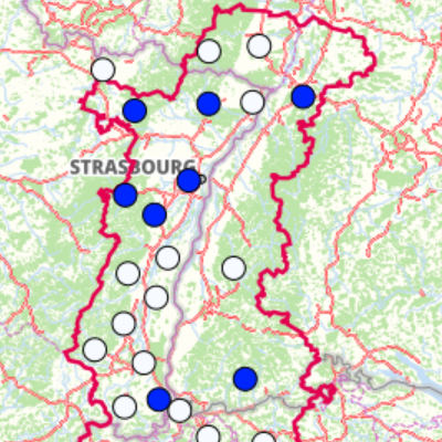
Centre des territoires avec un plan d'aménagement
Zentrum der Gebiete mit einem Raumplan
Centre of the areas with a managment plan
Documents de planification régionale - 2020 (SCOTs - RegionalPlan, Schéma Directeur...)
Übergeordneten Planungen - 2020 (SCOTs - RegionalPlan, Schéma Directeur...)
Upperrhine Regional Planning Documents - 2020 (SCOTs - RegionalPlan, Schéma Directeur...)
Simple
-
AlternativtitelAlternate titleAutre titre
-
Planification_regionale_centroide
Planification_regionale_centroide
Planification_regionale_centroide
-
Datum (Erstellung)Date (Creation)Date (Création)
- 2020-10-30
-
Datum (Publikation)Date (Publication)Date (Publication)
- 2020-10-30
-
KennungIdentifierIdentifiant
- Planif_Planung_2020
-
BearbeitungsstatusStatusÉtat
-
AbgeschlossenCompletedTerminé
Kontakt für die Ressource
Point of contact
Contact pour la ressource
-
mri:deliveryPointmri:deliveryPointmri:deliveryPoint
-
100, avenue d'Alsace
100, avenue d'Alsace
-
mri:citymri:citymri:city
-
COLMAR
-
mri:postalCodemri:postalCodemri:postalCode
-
68000
-
mri:countryCountrymri:country
-
FRANCE
FRANCE
-
Räumliche DarstellungsartSpatial representation typeType de représentation spatiale
-
VektorVectorvecteur
Räumliche Auflösung
Spatial resolution
Résolution spatiale
Vergleichsmassstab
Equivalent scale
Fraction représentative
-
MassstabszahlDenominatorDénominateur
- 100000
-
ThematikTopic categoryCatégorie de thème
-
-
E Planungsunterlagen und KatasterE Planning cadastreE Planification et cadastre
-
Ausdehnung
Extent
Étendue
Ausdehnung
Extent
Étendue
Zeitlicher Umfang
Temporal extent
Étendue temporelle
-
ZeitraumTime periodPériode
- 2016-10-30 2020-10-30
Ausdehnung
Extent
Étendue
Ausdehnung
Extent
Étendue
))
-
WartungsintervallMaintenance and update frequencyFréquence de mise à jour
-
JährlichAnnuallyAnnuelle
- Keywords
-
-
Données ouvertes
Open-Data
Open-Data
-
-
OrtPlacePosition
-
-
Rhin Supérieur
Oberrhein
Upper Rhine
-
- GEMET - INSPIRE themes, version 1.0
-
-
Services d'utilité publique et services publics
Versorgungswirtschaft und staatliche Dienste
Utility and governmental services
-
Zones de gestion, de restriction ou de réglementation et unités de déclaration
Bewirtschaftungsgebiete/Schutzgebiete/geregelte Gebiete und Berichterstattungseinheiten
Area management/restriction/regulation zones and reporting units
-
- GEMET - Concepts, version 2.4
-
-
aménagement du territoire
Flächenstruktur
land setup
-
document d'urbanisme
Stadtentwicklungsdokument
urban development document
-
plan d'aménagement
Entwicklungsplan
development plan
-
Ressourcenbeschränkungen
Resource constraints
Contraintes sur la ressource
-
NutzungsbeschränkungUse limitationLimitation d'utilisation
-
© + OSM contributors + Ajoutez logo GeoRhena en cas de réutilisation
© + OSM contributors + Das GeoRhena Logo verwenden für alle benutzung dieser Daten
© + OSM contributors + Add GeoRhena logo in case of reuse
Ressourcenbeschränkungen
Resource constraints
Contraintes sur la ressource
-
ZugriffsbeschränkungenAccess constraintsContraintes d'accès
-
Andere BeschränkungenOther restrictionsAutres restrictions
-
NutzungseinschränkungenUse constraintsContraintes d'utilisation
-
Andere BeschränkungenOther restrictionsAutres restrictions
-
Andere EinschränkungenOther constraintsAutres contraintes
-
Pas d'autre limitation
Keine andere Einschränkung
No other limitation
-
SpracheLanguageLangue
- English
-
ZeichenkodierungCharacter encodingEncodage de caractères
-
Utf8UTF8Utf8
-
AbgabeformatDistribution formatFormat de distribution
-
-
Géodonnée au format SHP
GeoDatei im SHP Format
SHP GeoData
-
Optionen für die digitale Übertragung
Digital transfer options
Options de transfert numérique
-
OnlineOnLine resourceRessource en ligne
-
planification_regionale_centroide
Centre des territoires avec un plan d'aménagement du Rhin SupérieurZentrum der Gebiete mit einem Raumplan im Oberrheingebiet
Optionen für die digitale Übertragung
Digital transfer options
Options de transfert numérique
-
OnlineOnLine resourceRessource en ligne
-
planning:planification_regionale_centroide
Centre des territoires avec un plan d'aménagement du Rhin SupérieurZentrum der Gebiete mit einem Raumplan im Oberrheingebiet
Optionen für die digitale Übertragung
Digital transfer options
Options de transfert numérique
-
OnlineOnLine resourceRessource en ligne
-
Téléchargement du Shapefile
Téléchargement du Shapefile
Téléchargement du Shapefile
-
ErklärungStatementGénéralités sur la provenance
-
GeoRhena + OSM contributors - 2019
GeoRhena + OSM contributors - 2019
GeoRhena + OSM contributors - 2020
-
BezugsebeneHierarchy levelNiveau
-
DatenbestandDatasetJeu de données
Metadata
-
Identifikator des MetadatensatzesMetadata identifierIdentifiant des métadonnées
- 6c9f8bae-b6db-4fc2-a906-aa83bc712541
-
SpracheLanguageLangue
- Français
-
ZeichenkodierungCharacter encodingEncodage de caractères
-
Utf8UTF8Utf8
-
SpracheLanguageLangue
- Deutsch
-
ZeichenkodierungCharacter encodingEncodage de caractères
-
Utf8UTF8Utf8
-
SpracheLanguageLangue
- English
-
ZeichenkodierungCharacter encodingEncodage de caractères
-
Utf8UTF8Utf8
Kontaktstelle für Metadaten
Contact
Point de contact des métadonnées
Anwendungsbereich der Metadaten
Type of resource
Type de ressource
-
Domäne der RessourcenanwendungResource scopeDomaine d'application de la ressource
-
DatenbestandDatasetJeu de données
-
Datumsangaben (Aktualisierung)Date info (Revision)Informations de date (Révision)
- 2025-01-30T09:15:53.810854Z
Metadatenstandard
Metadata standard
Norme des métadonnées
-
TitelTitleTitre
-
ISO 19115-3:2018
-
AusgabeEditionÉdition
-
1.0
)))